Deloit, Iowa
| Deloit, Iowa | |
|---|---|
| City | |
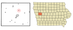 Location of Deloit, Iowa | |
| Coordinates: 42°5′50″N 95°19′9″W / 42.09722°N 95.31917°WCoordinates: 42°5′50″N 95°19′9″W / 42.09722°N 95.31917°W | |
| Country |
|
| State |
|
| County | Crawford |
| Area[1] | |
| • Total | 0.42 sq mi (1.09 km2) |
| • Land | 0.42 sq mi (1.09 km2) |
| • Water | 0 sq mi (0 km2) |
| Elevation | 1,270 ft (387 m) |
| Population (2010)[2] | |
| • Total | 264 |
| • Estimate (2012[3]) | 267 |
| • Density | 628.6/sq mi (242.7/km2) |
| Time zone | Central (CST) (UTC-6) |
| • Summer (DST) | CDT (UTC-5) |
| ZIP code | 51441 |
| Area code(s) | 712 |
| FIPS code | 19-19765 |
| GNIS feature ID | 0455874 |
Deloit is a city in Crawford County, Iowa, United States, along the Boyer River. The population was 264 at the 2010 census.
History
Deloit was platted in 1899.[4] It was named after Beloit, Wisconsin, but the name was altered in order to avoid repetition.[4]
Geography
Deloit is located at 42°5′50″N 95°19′9″W / 42.09722°N 95.31917°W (42.097204, -95.319168).[5]
According to the United States Census Bureau, the city has a total area of 0.42 square miles (1.09 km2), all of it land.[1]
Demographics
| Historical populations | ||
|---|---|---|
| Year | Pop. | ±% |
| 1910 | 208 | — |
| 1920 | 260 | +25.0% |
| 1930 | 280 | +7.7% |
| 1940 | 281 | +0.4% |
| 1950 | 235 | −16.4% |
| 1960 | 222 | −5.5% |
| 1970 | 279 | +25.7% |
| 1980 | 345 | +23.7% |
| 1990 | 296 | −14.2% |
| 2000 | 288 | −2.7% |
| 2010 | 264 | −8.3% |
| 1870 | 103 | −61.0% |
| 2014 | 265 | +157.3% |
| 2015 | 264 | −0.4% |
| Source:"American FactFinder". United States Census Bureau. and Iowa Data Center Source: | ||
2010 census
As of the census[2] of 2010, there were 264 people, 109 households, and 71 families residing in the city. The population density was 628.6 inhabitants per square mile (242.7/km2). There were 123 housing units at an average density of 292.9 per square mile (113.1/km2). The racial makeup of the city was 87.5% White, 11.0% from other races, and 1.5% from two or more races. Hispanic or Latino of any race were 22.0% of the population.
There were 109 households of which 28.4% had children under the age of 18 living with them, 45.9% were married couples living together, 14.7% had a female householder with no husband present, 4.6% had a male householder with no wife present, and 34.9% were non-families. 26.6% of all households were made up of individuals and 11% had someone living alone who was 65 years of age or older. The average household size was 2.42 and the average family size was 2.89.
The median age in the city was 36 years. 25.8% of residents were under the age of 18; 7.6% were between the ages of 18 and 24; 21.9% were from 25 to 44; 30.2% were from 45 to 64; and 14.4% were 65 years of age or older. The gender makeup of the city was 48.9% male and 51.1% female.
2000 census
As of the census[7] of 2000, there were 288 people, 114 households, and 76 families residing in the city. The population density was 684.4 people per square mile (264.8/km²). There were 123 housing units at an average density of 292.3 per square mile (113.1/km²). The racial makeup of the city was 93.40% White, 0.69% Native American, 2.78% from other races, and 3.12% from two or more races. Hispanic or Latino of any race were 4.17% of the population.
There were 114 households out of which 30.7% had children under the age of 18 living with them, 50.0% were married couples living together, 10.5% had a female householder with no husband present, and 33.3% were non-families. 24.6% of all households were made up of individuals and 10.5% had someone living alone who was 65 years of age or older. The average household size was 2.53 and the average family size was 2.95.
In the city the population was spread out with 27.8% under the age of 18, 6.3% from 18 to 24, 25.0% from 25 to 44, 27.8% from 45 to 64, and 13.2% who were 65 years of age or older. The median age was 38 years. For every 100 females there were 98.6 males. For every 100 females age 18 and over, there were 94.4 males.
The median income for a household in the city was $36,250, and the median income for a family was $40,568. Males had a median income of $26,875 versus $15,000 for females. The per capita income for the city was $14,446. About 3.4% of families and 6.0% of the population were below the poverty line, including 2.5% of those under the age of eighteen and 5.7% of those sixty five or over.
References
- 1 2 "US Gazetteer files 2010". United States Census Bureau. Retrieved 2012-05-11.
- 1 2 "American FactFinder". United States Census Bureau. Retrieved 2012-05-11.
- ↑ "Population Estimates". United States Census Bureau. Retrieved 2013-05-23.
- 1 2 Chicago and North Western Railway Company (1908). A History of the Origin of the Place Names Connected with the Chicago & North Western and Chicago, St. Paul, Minneapolis & Omaha Railways. p. 63.
- ↑ "US Gazetteer files: 2010, 2000, and 1990". United States Census Bureau. 2011-02-12. Retrieved 2011-04-23.
- ↑ "Census of Population and Housing". Census.gov. Retrieved June 4, 2015.
- ↑ "American FactFinder". United States Census Bureau. Retrieved 2008-01-31.
Municipalities and communities of Crawford County, Iowa, United States | ||
|---|---|---|
| Cities | ||
| Townships | ||
| Unincorporated communities | ||
| Footnotes | ‡This populated place also has portions in an adjacent county or counties | |