Decaturville crater

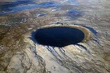
The topography of the Decaturville crater is highly eroded.
The Decaturville crater, also referred to as the Decaturville Dome, is an impact crater in Missouri, United States, and is one of the 38th parallel structures.
It is 6 km in diameter and the age is estimated to be less than 300 million years (Permian or younger). The crater is exposed at the surface.[1]
Decaturville Crater was described and mapped in detail by T. W. Offield and H. A. Pohn under NASA funding in the 1970s. Their work was reported in a 1979 Geological Survey Professional Paper that provides the most detailed description to date.[2]
The effect that this impact had on the surrounding bedrock can be seen in a roadcut that runs along Highway 5 about 16 miles north of Lebanon.
References
- ↑ "Decaturville". Earth Impact Database. University of New Brunswick. Retrieved 2009-08-13.
- ↑ Offield, T. W.; Pohn H. A. (1979). "Geology of the Decaturville impact structure, Missouri: U.S." (PDF). Geological Survey Professional Paper. 1042: 48 pages.
Coordinates: 37°54′N 92°43′W / 37.900°N 92.717°W
This article is issued from Wikipedia - version of the 8/5/2014. The text is available under the Creative Commons Attribution/Share Alike but additional terms may apply for the media files.