Creag Meagaidh
| Creag Meagaidh | |
|---|---|
 Coire Ardair and Creag Meagaidh | |
| Highest point | |
| Elevation | 1,130 m (3,710 ft) [1] |
| Prominence |
867 m (2,844 ft) Ranked 18th in British Isles |
| Parent peak | Ben Nevis |
| Listing | Marilyn, Munro |
| Naming | |
| Translation | Bogland crag (Gaelic) |
| Pronunciation | Scottish Gaelic: [ˈkʰɾʲek ˈmekɪ] |
| Geography | |
| Location | Glen Spean, Scotland |
| OS grid | NN418875 |
| Topo map | OS Landranger 34, 42 |
Creag Meagaidh is a mountain on the northern side of Glen Spean in Scotland. It is a complex mountain, taking the form of a flat summit plateau from which five ridges radiate, and is most famed for the cliffs surrounding the corrie of Coire Ardair on the north-eastern face. These crags are a renowned venue for winter and ice climbing, though being somewhat vegetated they are less suited to "normal" climbing.
The name Creag Meagaidh is also applied to refer to the neighbouring peaks of Stob Poite Coire Ardair and Carn Liath, which together may be termed the Creag Meagaidh range.
All three peaks in the range may be climbed from Aberarder on the A86 road by initially following the path leading up Coire Ardair, before striking north to the summit of Carn Liath. A circuit of the glen may be made by returning to Aberarder by way of Creag Meagaidh's east ridge. The most direct route to the summit of Creag Meagaidh ascends from the head of the corrie to reach a narrow gap between the crags known as The Window. The Window forms the bealach between Creag Meagaidh and Stob Poite Coire Ardair. Creag Meagaidh may also be climbed from Moy to the southeast.
Creag Meagaidh is designated as both a Special Protection Area and a National Nature Reserve, and the number of grazing animals is controlled. This has led to a regrowth of the native woodland of birch, alder, willow, rowan and oak. The site is also an important breeding ground for many species of birds, in particular the dotterel Charadrius morinellus.
References
- ↑ "walkhighlands Creag Meagaidh". walkhighlands.co.uk. 2013. Retrieved 21 December 2013.
External links
Coordinates: 56°57′06″N 4°36′10″W / 56.95162°N 4.60274°W
| Northern Highlands | 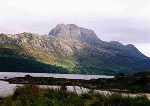   | |
|---|---|---|
| Western Highlands | ||
| Central and Eastern Highlands | ||
| Southern Highlands | ||
| Islands | ||
| Scottish Lowlands, England and Wales | ||
 |
| | |