Ben Lawers
| Ben Lawers | |
|---|---|
 Ben Lawers seen from Beinn Ghlas | |
| Highest point | |
| Elevation | 1,214 m (3,983 ft) [1] |
| Prominence |
c. 909 m Ranked 11th in British Isles |
| Parent peak | Ben Nevis |
| Listing | Munro, Marilyn, Council top (Perth and Kinross), County top (Perthshire) |
| Coordinates | 56°32′44″N 4°13′15″W / 56.54556°N 4.22083°WCoordinates: 56°32′44″N 4°13′15″W / 56.54556°N 4.22083°W |
| Naming | |
| Translation | Hill of the loud stream or hoof or claw mountain (Gaelic) |
| Pronunciation | Scottish Gaelic: [peɲˈlˠ̪avəɾʲ] |
| Geography | |
| Location | Perth and Kinross, Scotland |
| OS grid | NN636414 |
| Topo map | OS Landranger 51 |

Ben Lawers (Gaelic: Beinn Labhair) is the highest mountain in the southern part of the Scottish Highlands. It lies to the north side of Loch Tay, and is the highest point of a long ridge that includes seven Munros. Ben Lawers was long thought to be over 4,000 feet (1,219.2 m) in height; accurate measurement in the 1870s showed it to be some 17 feet (5.2 m) short of this figure. In 1878, a group of twenty men spent a day building a large cairn in the hope of bringing the summit above the "magic" figure. The cairn is no longer there; in any case the Ordnance Survey ignored it as an artificial structure that was not truly part of the hill.
History
There is much evidence of former settlements and other human activity on the southern slopes of Ben Lawers above Loch Tay. The discovery of many boulders with cup and ring marks "suggests it was a very significant landscape in prehistory."[2] There are ruins of cottages each surrounded by a small group of trees and the ridged pastures are signs of early cultivation. Overgrown tracks climb up the mountain from the valley to the peat beds and sheilings on the hillside. The fertile limestone and schist soils on these southern slopes have been farmed since very early times and there are many Bronze Age remains.
Prior to the 14th century, the mountain stood on the lands of Clan MacMillan. Chalmers of Lawers obtained the land by force from the clan in the mid 14th century in the reign of David II. The land was confiscated from the Chalmers family in 1473 by James III and given to Sir Colin Campbell of Glenorchy after Thomas Chalmers was implicated in the murder of James I. The lands have mainly remained in the ownership of the Campbells of Glenorchy and Breadalbane right up to the present day, with some notable exceptions. Many of the farms were sold off in the late 1940s and today some, like Tombreck, are leading the way in regenerating their homeland and learning to preserve its beauty whilst creating a sustainable environment for the people who live there.
National Trust for Scotland
Most of the south side of the Ben Lawers range has since 1950 been owned by the National Trust for Scotland and was purchased through the generosity of Percy Unna, a mountaineer and one time president of the Scottish Mountaineering Club. The area of land under Trust ownership was extended in 1996 by the purchase of the neighbouring Tarmachan range. The Trust owned a visitor centre located at the western end of the range that had an exhibition that explained the geological formation of the mountain, but it was closed and demolished in 2010.
A new car park has been built on the opposite side of the road, from where a path leads to the summit of Ben Lawers by way of the intermediate peak of Beinn Ghlas. There is a nature trail on the lower section of this path, with information leaflets available in the car park.
Flora and fauna
Ben Lawers is designated as a National Nature Reserve due to the abundance of rare alpine plants. It is regarded by botanists as one of the richest areas for alpine flora in the UK, due to the schist rocks of the mountain which are situated at the correct altitude for the plants. The rocks supply an adequate amount of calcium, magnesium, sodium, potassium and iron to the plants and breaks down to a clayish soil which retains moisture. Some of the plants found on Lawers include Alpine Forget-me-not, roseroot, Net-leaved Willow and most of the Saxifrages. The mountain is also of interest to zoologists. Some of the bird species include ravens, ring ouzels, red grouse, ptarmigan, dippers and curlews. Other rare species include the Viviparous lizard and the Wildcat.[3]
Ascents
Alternative routes that avoid the erosion caused by the popularity of the two routes described above usually start by following Lawers Burn, which meet the A827 at the village of Lawers. Heading north from the burn allows the walker to climb the peaks to the northeast of Ben Lawers on the way. The most direct route from Lawers is to continue along the burn until Lochan nan Cat ("small lake of the cat"), then heading straight to the summit by way of the east ridge.
Gallery of images
-

Ben Lawers seen from Loch Tay
-

Ben Lawers in winter
-

Lochan Nan Cat from the summit of Ben Lawers
-

Ben Lawers and Meall Garbh
References
- ↑ "walkhighlands Ben Lawers". walkhighlands.co.uk. 2013. Retrieved 20 October 2013.
- ↑ "Ancient stone artwork discovered". BBC. 17 August 2009. Archived from the original on 21 September 2009. Retrieved 20 September 2009.
- ↑ "Ben Lawers (NTS Guide)" Pages 24 & 25 (Gives biology details).
- Ben Lawers, National Trust for Scotland, ISBN 978-0-901625-54-0
External links
- Computer generated summit panoramas North South Index
- NTS Ben Lawers page
- Ben Lawers Historic Landscape Project
- Ben Lawers NNR
- Ben Lawers walking Route Head-start at 1400 feet
See also
| Northern Highlands | 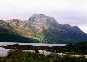   | |
|---|---|---|
| Western Highlands | ||
| Central and Eastern Highlands | ||
| Southern Highlands | ||
| Islands | ||
| Scottish Lowlands, England and Wales | ||

