Clontarf, Queensland
| Clontarf Queensland | |||||||||||||
|---|---|---|---|---|---|---|---|---|---|---|---|---|---|
 | |||||||||||||
| Population | 7,911 (2011 census)[1] | ||||||||||||
| • Density | 1,256/km2 (3,252/sq mi) | ||||||||||||
| Established | 1971 | ||||||||||||
| Postcode(s) | 4019 | ||||||||||||
| Elevation | 12 m (39 ft) | ||||||||||||
| Area | 6.3 km2 (2.4 sq mi) | ||||||||||||
| Location |
| ||||||||||||
| LGA(s) | Moreton Bay Region | ||||||||||||
| Region | South East Queensland | ||||||||||||
| State electorate(s) | Redcliffe | ||||||||||||
| Federal Division(s) | Petrie | ||||||||||||
| |||||||||||||
Clontarf is a suburb of the Moreton Bay Region, Queensland, Australia.[2] It is in the south-west of the Redcliffe peninsula, approximately 29 kilometres (18 mi) north-northeast of Brisbane, the state capital. It was named after Clontarf in Ireland.
The land use is a mix of residential and light industrial.
Attractions and features

Clontarf is connected to Brisbane City, across Bramble Bay, by the Houghton Highway which is a 2.7 km long causeway that provides access to the southern tip of Redcliffe City, greatly decreasing the travel time between Redcliffe and Brisbane. The current pair of bridges, Houghton Highway and its twin Ted Smout Memorial Bridge, replaced the original Hornibrook Bridge which is now closed and mostly demolished.
Clontarf Beach and Bells Beach are two of the closest beaches to Brisbane City.
Pelican Park is known for its kite flying conditions, and a local industry has built around the sport. On weekends, many kites can be seen flying above Clontarf from the Hornibrook Bridge. During May, the Redcliffe Kite Club, based in Clontarf holds a two-day kite event called Kitefest.
Demographics
In the 2011 census, Clontarf recorded a population of 7,911 people, 50.2% female and 49.8% male.
The median age of the Clontarf population was 42 years, 5 years above the national median of 37.
76.2% of people living in Clontarf were born in Australia. The other top responses for country of birth were New Zealand 5.5%, England 5.2%, Scotland 0.8%, Philippines 0.8%, South Africa 0.5%.
90.7% of people spoke only English at home; the next most common languages were 0.4% Tagalog, 0.4% German, 0.3% Dutch, 0.3% Italian, 0.3% Samoan.
Heritage listings
Brighton has a number of heritage-listed sites, including:
- Hornibrook Highway: Hornibrook Bridge (the first of the three bridges)[3]
Industry
Clontarf's west hosts the largest industrial area in the Redcliffe area, and the area is a significant source of employment for the region. Many residents of Clontarf also commute to Brisbane daily for work. Most commuters travel by car, as there is no train line to Redcliffe.
Clontarf is host to two adjacent medium-sized shopping centres, on the southern tip of the suburb. Most retail commerce in the suburb revolves around small business however, and there are many stand alone corner stores and other small businesses still in existence.
Aussie Traveller, the largest caravan awning/annexe company in Australia now call Clontarf home
Education
Several educational institutions are located within Clontarf: Clontarf Beach State High School, which opened in 1964 and has over 1240 enrolled students,[4] Clontarf Beach State School (1950) with approximately 350 students,[5] and a private school, Grace Lutheran Primary School (1971), with approximately 430 students.[6]
Public transport
Clontarf is served by several bus routes: Route 315, a limited-stops Monday-Friday service to Brisbane City; Route 693, an internal route within Redcliffe City, and Routes 690 and 695 to Sandgate railway station, an approximately 10- to 15-minute commute. All services are provided by Hornibrook Bus Lines.[7]
Gallery
-
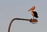
Roosting pelican on the Houghton
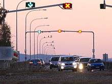
-

Houghton Highway at sunset
-

Coles Express Clontarf
References
- ↑ Australian Bureau of Statistics (25 October 2007). "Clontarf (Statistical Local Area)". 2006 Census QuickStats. Retrieved 11 August 2007.
- ↑ "Clontarf (entry 45494)". Queensland Place Names. Queensland Government. Retrieved 30 May 2014.
- ↑ "Hornibrook Highway Bridge (entry 601246)". Queensland Heritage Register. Queensland Heritage Council. Retrieved 11 July 2013.
- ↑ Queensland Government Department of Education, Training and the Arts. "Clontarf Beach State High School (SS) : Secondary Enrolments". Schools Directory. Retrieved 12 August 2007.
- ↑ Queensland Government Department of Education, Training and the Arts. "Clontarf Beach State School (SS) : Primary Enrolments". Schools Directory. Retrieved 12 August 2007.
- ↑ Grace Lutheran Primary School (2007). "Our School". Archived from the original on 16 August 2007. Retrieved 8 September 2007.
- ↑ 310/N310/315 (PDF) (315) timetable, effective 3 September 2007; 690 (PDF), 693/696/697 (PDF) (693) and 695 (PDF) timetables, effective 20 June 2005. Retrieved on 8 September 2007.
External links
Coordinates: 27°14′47″S 153°04′58″E / 27.2463°S 153.0827°E