Atlanta South Regional Airport
| Atlanta South Regional Airport (formerly Henry County Airport) Tara Field | |||||||||||
|---|---|---|---|---|---|---|---|---|---|---|---|
 | |||||||||||
| IATA: none – ICAO: none – FAA LID: 4A7 | |||||||||||
| Summary | |||||||||||
| Airport type | Public | ||||||||||
| Owner | Henry County | ||||||||||
| Serves | Hampton, Georgia | ||||||||||
| Elevation AMSL | 874 ft / 266 m | ||||||||||
| Coordinates | 33°23′21″N 084°19′56″W / 33.38917°N 84.33222°WCoordinates: 33°23′21″N 084°19′56″W / 33.38917°N 84.33222°W | ||||||||||
| Website | www.co.henry.ga.us/... | ||||||||||
| Map | |||||||||||
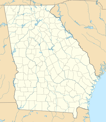 4A7 Location of airport in Georgia | |||||||||||
| Runways | |||||||||||
| |||||||||||
| Statistics (2011) | |||||||||||
| |||||||||||
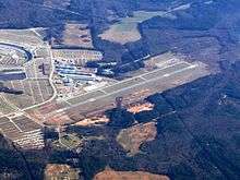
Atlanta South Regional Airport[1] (FAA LID: 4A7), also known as Tara Field, is a public-use county airport located three nautical miles (6 km) west of the central business district of Hampton, a city in Henry County, Georgia, United States.[2] It was known as Clayton County Airport – Tara Field,[4] which was the name still used by the Federal Aviation Administration (FAA)[2] and the Georgia Department of Transportation (GDOT) until approval of the Atlanta South Regional Airport name.[3] The airport was renamed Atlanta South Regional Airport, which was approved by the airport board of commissioners in December 2011, and was approved by the GDOT and the FAA before it went into effect.
Although the airport is located in Henry County, it was owned and operated by Clayton County to the north from 1992 until 2011. It is not near most of that county, except for its very small southern tip. The north end of Clayton County has part of Hartsfield-Jackson Atlanta International Airport, thus Tara Field served general aviation, especially for the Atlanta Motor Speedway immediately next to it. At its July 12, 2011 meeting, the Clayton County Board of Commissioners voted to sell the airport to Henry County in a deal worth $17.7 million. The Henry County Board of Commissioners agreed to the purchase at a meeting on July 13, 2011, and the sale was completed in August 2011. Henry County paid just $2.7 million toward the purchase price, with the Federal Aviation Administration and the Georgia Department of Transportation funding the balance of $15 million.
The Henry County Board of Commissioners voted Tuesday, December 4, 2012 to move forward with the runway expansion project, which extended the runway to 5,500 feet and widened it by 25 feet. The project was complete in time for the Labor Day race at Atlanta Motor Speedway in Hampton. This airport is included in the National Plan of Integrated Airport Systems for 2011–2015, which categorized it as a general aviation facility.[5] There is no weather station or FAA flight info reported for this airport.
On April 15 2013 the airport runway was closed for 2 months to allow for construction on widening of the runway. Phase I of the Airport Expansion began in February 2013 and was completed for the Fall 2013 NASCAR races. Expansion consisted of adding 1,000 feet to the 24 end and widening the existing runway 25 feet. At the completion of Phase I, the new runway will be 5,503 feet long by 100 feet wide.
History
In July 2005, the airport and the adjacent speedway were hit by an F2 tornado on the evening of July 6. Millions of dollars in damage was done to the airport, in addition to the tens of millions at the speedway. Four airplanes were flipped over, hangars were torn apart, and fiberglass insulation and sheet metal were plastered into iron fences, along with another plane. The storm was a result of Hurricane Cindy, after it had already been downgraded to a tropical depression after landfall.[6]
Another severe thunderstorm struck in 2014, causing a downburst with winds at minimal hurricane strength on the evening of September 7th. Planes were again flipped over, destroying six of them and damaging another 15, in addition to relatively minor damage to some hangar doors and other airport facilities.
Facilities and aircraft
The airport covers an area of 160 acres (65 ha) at an elevation of 874 feet (266 m) above mean sea level. It has one runway designated 6/24 with an asphalt surface measuring 4,503 by 75 feet (1,373 x 23 m).[2]
For the 12-month period ending June 9, 2011, the airport had 42,000 aircraft operations, an average of 115 per day: 96% general aviation and 4% air taxi. At that time there were 93 aircraft based at this airport: 63% single-engine, 15% multi-engine, 4% jet, 14% helicopter, and 3% ultralight.[2]
References
- 1 2 "Henry County Airport". Henry County Board of Commissioners. Retrieved June 25, 2012.
- 1 2 3 4 5 FAA Airport Master Record for 4A7 – CLAYTON COUNTY - TARA FIELD (Form 5010 PDF). Federal Aviation Administration. Effective April 5, 2012.
- 1 2 "4A7 – CLAYTON COUNTY - TARA FIELD". Georgia Department of Transportation. Retrieved June 25, 2012.
- ↑ "Clayton County Airport - Tara Field". Clayton County. Archived from the original on June 18, 2009.
- ↑ "2011–2015 NPIAS Report, Appendix A" (PDF). National Plan of Integrated Airport Systems. Federal Aviation Administration. October 4, 2010. Archived from the original (PDF, 2.03 MB) on 2012-09-27.
- ↑ "Storm Overturns Four Planes, Two Hangars at Tara Field in Ga.". AviationPros.com. Associated Press. July 7, 2005.
External links
- Aerial image as of April 2002 from USGS The National Map
- FAA Terminal Procedures for 4A7, effective November 10, 2016
- Resources for this airport:
- FAA airport information for 4A7
- AirNav airport information for 4A7
- FlightAware airport information and live flight tracker
- SkyVector aeronautical chart for 4A7