Hampton, Georgia
| Hampton, Georgia | |
|---|---|
| City | |
 Location in Henry County and the state of Georgia | |
| Coordinates: 33°22′53″N 84°17′22″W / 33.38139°N 84.28944°WCoordinates: 33°22′53″N 84°17′22″W / 33.38139°N 84.28944°W | |
| Country | United States |
| State | Georgia |
| County | Henry |
| Area | |
| • Total | 4.3 sq mi (11.2 km2) |
| • Land | 4.3 sq mi (11.1 km2) |
| • Water | 0 sq mi (0.1 km2) |
| Elevation | 883 ft (269 m) |
| Population (2010) | |
| • Total | 6,987 |
| • Density | 897/sq mi (344.4/km2) |
| Time zone | Eastern (EST) (UTC-5) |
| • Summer (DST) | EDT (UTC-4) |
| ZIP code | 30228 |
| Area code(s) | 770/678/470 |
| FIPS code | 13-36276[1] |
| GNIS feature ID | 0315076[2] |
Hampton is a city in southwestern Henry County, Georgia, United States. As of the 2010 census, the city had a population of 6,987.[3] Census Estimates for 2005 show a population of 4,743. Hampton mailing addresses also dip into eastern Clayton County and northern Spalding County. It is a Southeastern Suburb in the Atlanta Metropolitan area.
History
The city was once known as Bear Creek or Bear Creek Station, named after a creek that runs through the area. The town was moved, established and renamed in 1873 when the Central Railroad of Georgia was built approx. one mile to the east. It was named after Brig. General Wade Hampton an American soldier in Revolutionary War and War of 1812.
Points of Interest
The Atlanta Motor Speedway and the Henry County Airport are located 3 miles (4.8 km) west of Hampton. The Atlanta Air Route Traffic Control Center, the Federal Aviation Administration's ARTCC for the airspace over Atlanta and other parts of the Southeast U.S., is located in Hampton.
Geography
Hampton is located at 33°22′53″N 84°17′22″W / 33.38139°N 84.28944°W (33.381522, -84.289573).[4]
According to the United States Census Bureau, the city has a total area of 4.3 square miles (11 km2), of which, 4.3 square miles (11 km2) of it is land and 0.04 square miles (0.10 km2) of it (0.69%) is water.
Major highways
Sports
Hampton is home to the "Atlanta Motor Speedway".
| Event | Sport | League | Venue |
|---|---|---|---|
| Sprint Cup Series,
Xfinity Series, Camping World Truck Series, O'Rilly Auto Parts Friday Night Drags, Thursday Thunder Series |
Motorsports | NASCAR | Atlanta Motor Speedway |
Demographics
| Historical population | |||
|---|---|---|---|
| Census | Pop. | %± | |
| 1880 | 621 | — | |
| 1890 | 422 | −32.0% | |
| 1900 | 468 | 10.9% | |
| 1910 | 1,093 | 133.5% | |
| 1920 | 927 | −15.2% | |
| 1930 | 1,002 | 8.1% | |
| 1940 | 619 | −38.2% | |
| 1950 | 864 | 39.6% | |
| 1960 | 1,253 | 45.0% | |
| 1970 | 1,551 | 23.8% | |
| 1980 | 2,059 | 32.8% | |
| 1990 | 2,694 | 30.8% | |
| 2000 | 3,857 | 43.2% | |
| 2010 | 6,987 | 81.2% | |
| Est. 2015 | 7,372 | [5] | 5.5% |
As of the census[1] of 2000, there were 3,857 people, 1,411 households, and 1,049 families residing in the city. The population density was 899.6 people per square mile (347.1/km²). There were 1,525 housing units at an average density of 355.7 per square mile (137.3/km²). The racial makeup of the city was 84.16% White, 13.38% African American, 0.16% Native American, 0.67% Asian, 0.57% from other races, and 1.06% from two or more races. Hispanic or Latino of any race were 1.74% of the population.
There were 1,411 households out of which 41.0% had children under the age of 18 living with them, 55.3% were married couples living together, 14.7% had a female householder with no husband present, and 25.6% were non-families. 19.6% of all households were made up of individuals and 6.9% had someone living alone who was 65 years of age or older. The average household size was 2.73 and the average family size was 3.12.
In the city the population was spread out with 29.8% under the age of 18, 8.8% from 18 to 24, 35.4% from 25 to 44, 17.0% from 45 to 64, and 8.9% who were 65 years of age or older. The median age was 31 years. For every 100 females there were 92.4 males. For every 100 females age 18 and over, there were 88.7 males.
The median income for a household in the city was $46,094, and the median income for a family was $48,310. Males had a median income of $37,750 versus $25,286 for females. The per capita income for the city was $18,924. About 2.1% of families and 5.0% of the population were below the poverty line, including 1.8% of those under age 18 and 14.6% of those age 65 or over.
Schools
Public
Elementary
- Hampton Charter Elementary School
- Mt. Carmel Elementary School
- Rocky Creek Elementary School
Middle
- Hampton Middle School
High
- Luella High School
- Hampton High School
References
- 1 2 "American FactFinder". United States Census Bureau. Retrieved 2008-01-31.
- ↑ "US Board on Geographic Names". United States Geological Survey. 2007-10-25. Retrieved 2008-01-31.
- ↑ http://quickfacts.census.gov/qfd/states/13/1336276.html
- ↑ "US Gazetteer files: 2010, 2000, and 1990". United States Census Bureau. 2011-02-12. Retrieved 2011-04-23.
- ↑ "Annual Estimates of the Resident Population for Incorporated Places: April 1, 2010 to July 1, 2015". Retrieved July 2, 2016.
- ↑ "Census of Population and Housing". Census.gov. Retrieved June 4, 2015.
|  | |||||||
|
| ||||||||
| ||||||||
Municipalities and communities of Henry County, Georgia, United States | ||
|---|---|---|
| Cities | 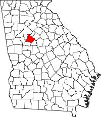 | |
| CDP | ||
| Unincorporated communities | ||
| Footnotes | ‡This populated place also has portions in an adjacent county or counties | |