Clayton, Louisiana
| Clayton, Louisiana | |
| Town | |
 Clayton Cotton Gin | |
| Country | United States |
|---|---|
| State | Louisiana |
| Parish | Concordia |
| Elevation | 56 ft (17.1 m) |
| Coordinates | 31°43′08″N 91°32′20″W / 31.71889°N 91.53889°WCoordinates: 31°43′08″N 91°32′20″W / 31.71889°N 91.53889°W |
| Area | 1.63 sq mi (4.22 km2) |
| - land | 1.58 sq mi (4.09 km2) |
| - water | 0.05 sq mi (0.13 km2) |
| Population | 711 (2010) |
| Density | 449.5/sq mi (173.6/km2) |
| Mayor | Josephine Taylor Washington (D) Unseated Rydell Turner (D), March 5, 2016 Police Chief: Bobby L. Madison, Sr. (D) |
| Timezone | CST (UTC-6) |
| - summer (DST) | CDT (UTC-5) |
| Area code | 318 |
 Location of Clayton in Louisiana
| |
 Location of Louisiana in the United States
| |
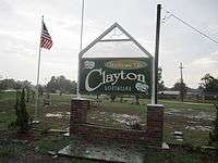
Clayton is a town in northern Concordia Parish, Louisiana, United States. The population was 711 at the 2010 census.[1] Cotton is a principal commodity in the area. Clayton is located on the Tensas River, important for fishing and boating, promoted through a U.S. Army Corps of Engineers-maintained boat launch. The Tensas River merges with the Black River in Jonesville in Catahoula Parish.
Louisiana State Representative Andy Anders is from Clayton and Ferriday.
Among the businesses in the community are Cross Keys Bank and David's Grocery.
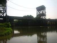
A major employer in the town was Clayton Gin Company which closed in the early 2000s and was mostly demolished in the early 2010s. The Clayton Gin was originally constructed in the 1940s by W. Howard Davis and his brother Doyle E. Davis. The gin operated under the name "Davis Bros. Gin Co.". The last surviving brother, Howard Davis, died in 1972 and the gin continued to operate under the management of his son-in-law Sam D. Cole until his death in 1979. The gin was sold in the early 1980s and continued operation as the "Clayton Gin Company" until the early 2000s.
Geography
Clayton is located in northern Concordia Parish at 31°43′8″N 91°32′20″W / 31.71889°N 91.53889°W (31.718837, -91.538902),[2] along the south bank of the Tensas River. Catahoula Parish is to the north across the river. U.S. Route 425 passes through the center of the town, leading north 36 miles (58 km) to Winnsboro and south 6 miles (10 km) to Ferriday and 18 miles (29 km) to Natchez, Mississippi. U.S. Route 65 has its southern terminus in Clayton; it leads north 56 miles (90 km) to Tallulah and 998 miles (1,606 km) to its northern terminus in Minnesota.
According to the United States Census Bureau, the town has a total area of 1.63 square miles (4.23 km2), of which 1.58 square miles (4.10 km2) is land and 0.05 square miles (0.14 km2), or 3.24%, is water.[1]
Demographics
| Historical population | |||
|---|---|---|---|
| Census | Pop. | %± | |
| 1950 | 657 | — | |
| 1960 | 882 | 34.2% | |
| 1970 | 1,103 | 25.1% | |
| 1980 | 1,204 | 9.2% | |
| 1990 | 917 | −23.8% | |
| 2000 | 858 | −6.4% | |
| 2010 | 711 | −17.1% | |
| Est. 2015 | 686 | [3] | −3.5% |
As of the census[5] of 2000, there were 858 people, 317 households, and 220 families residing in the town. The population density was 539.4 people per square mile (208.3/km²). There were 361 housing units at an average density of 226.9 per square mile (87.7/km²). The racial makeup of the town was 31.70% White, 67.25% African American, and 1.05% from two or more races. Hispanic or Latino of any race were 0.47% of the population.
There were 317 households out of which 34.1% had children under the age of 18 living with them, 32.8% were married couples living together, 31.9% had a female householder with no husband present, and 30.3% were non-families. 24.9% of all households were made up of individuals and 12.9% had someone living alone who was 65 years of age or older. The average household size was 2.71 and the average family size was 3.24.
In the town, the population was spread out with 33.4% under the age of 18, 9.6% from 18 to 24, 21.7% from 25 to 44, 21.7% from 45 to 64, and 13.6% who were 65 years of age or older. The median age was 32 years. For every 100 females there were 90.7 males. For every 100 females age 18 and over, there were 83.6 males.
The median income for a household in the town was $14,100, and the median income for a family was $15,598. Males had a median income of $22,250 versus $12,500 for females. The per capita income for the town was $7,955. About 38.9% of families and 45.3% of the population were below the poverty line, including 59.0% of those under age 18 and 34.9% of those age 65 or over.
References
- 1 2 "Geographic Identifiers: 2010 Demographic Profile Data (G001): Clayton town, Louisiana". U.S. Census Bureau, American Factfinder. Retrieved August 20, 2014.
- ↑ "US Gazetteer files: 2010, 2000, and 1990". United States Census Bureau. 2011-02-12. Retrieved 2011-04-23.
- ↑ "Annual Estimates of the Resident Population for Incorporated Places: April 1, 2010 to July 1, 2015". Retrieved July 2, 2016.
- ↑ "Census of Population and Housing". Census.gov. Archived from the original on May 11, 2015. Retrieved June 4, 2015.
- ↑ "American FactFinder". United States Census Bureau. Archived from the original on 2013-09-11. Retrieved 2008-01-31.
External links
- Clayton Progress Community Progress Site for Clayton, LA
Municipalities and communities of Concordia Parish, Louisiana, United States | ||
|---|---|---|
| Cities | 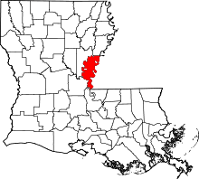 | |
| Towns | ||
| CDPs | ||
| Other unincorporated communities |
| |