Clam Gulch, Alaska
| Clam Gulch, Alaska | |
|---|---|
| CDP | |
|
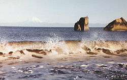
Waves on the rocky beach at Clam Gulch | |
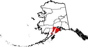
 Location of Clam Gulch, Alaska | |
| Coordinates: 60°13′40″N 151°23′38″W / 60.22778°N 151.39389°W | |
| Country | United States |
| State | Alaska |
| Borough | Kenai Peninsula |
| Government | |
| • Borough mayor | Mike Navarre[1] |
| • State senator | Gary Stevens (R) |
| • State rep. | Paul Seaton (R) |
| Area | |
| • Total | 13.7 sq mi (35.6 km2) |
| • Land | 13.7 sq mi (35.6 km2) |
| • Water | 0 sq mi (0 km2) |
| Elevation | 269 ft (82 m) |
| Population (2000) | |
| • Total | 173 |
| Time zone | Alaska (AKST) (UTC-9) |
| • Summer (DST) | AKDT (UTC-8) |
| ZIP code | 99568 |
| Area code(s) | 907 |
| FIPS code | 02-15320 |
| GNIS feature ID | 1412797 |
Clam Gulch is a census-designated place (CDP) in Kenai Peninsula Borough, Alaska, United States. At the 2000 census the population was 173.
Geography
Clam Gulch is located at 60°13′40″N 151°23′38″W / 60.22778°N 151.39389°W (60.227786, -151.393907)[2] on the shores of Cook Inlet. The only road access is via the Sterling Highway.
According to the United States Census Bureau, the CDP has a total area of 13.7 square miles (35 km2), all of it land.
//www.google.com/maps/@60.2258704,-151.402415,1626m/data=!3m1!1e3
Demographics
As of the census[3] of 2000, there were 173 people, 67 households, and 42 families residing in the CDP. The population density was 12.6 people per square mile (4.9/km²). There were 115 housing units at an average density of 8.4/sq mi (3.2/km²). The racial makeup of the CDP was 92.49% White, 2.89% Native American, 1.16% Asian, and 3.47% from two or more races.
There were 67 households out of which 40.3% had children under the age of 18 living with them, 46.3% were married couples living together, 11.9% had a female householder with no husband present, and 37.3% were non-families. 28.4% of all households were made up of individuals and 6.0% had someone living alone who was 65 years of age or older. The average household size was 2.58 and the average family size was 3.21.
In the CDP the population was spread out with 31.8% under the age of 18, 5.8% from 18 to 24, 27.2% from 25 to 44, 24.3% from 45 to 64, and 11.0% who were 65-84 years of age. The median age was 38 years. For every 100 females there were 106.0 males. For every 100 females age 16 and over, there were 103.4 males.
The median income for a household in the CDP was $37,500, and the median income for a family was $44,375. Males had a median income of $25,625 versus $27,083 for females. The per capita income for the CDP was $17,983. About 7.0% of families and 8.1% of the population were below the poverty line, including 10.2% of those under the age of eighteen and none of those sixty five or over.
Activities
Clam Gulch is visited by tourists who participate in clam digging on the beach during low tides. There is a State Recreation Area with a large campground and access to the clamming beaches.[4] In the winter there are many 'poker runs' by snow-machine enthusiasts and in the past Clam Gulch has been the half-way point for the Tustumena 200 Sled Dog Race.
References
- ↑ 2015 Alaska Municipal Officials Directory. Juneau: Alaska Municipal League. 2015. p. 9.
- ↑ "US Gazetteer files: 2010, 2000, and 1990". United States Census Bureau. 2011-02-12. Retrieved 2011-04-23.
- ↑ "American FactFinder". United States Census Bureau. Archived from the original on 2013-09-11. Retrieved 2008-01-31.
- ↑ Alaska Department of Natural Resources, Division of Parks and Outdoor Recreation Clam Gulch State Recreation Area
Coordinates: 60°13′40″N 151°23′38″W / 60.227786°N 151.393907°W