Passes-Dangereuses, Quebec
| Passes-Dangereuses | |
|---|---|
| Unorganized territory | |
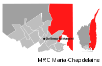 | |
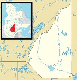 Passes-Dangereuses Location in Saguenay–Lac-Saint-Jean Quebec. | |
| Coordinates: 48°58′N 72°04′W / 48.967°N 72.067°WCoordinates: 48°58′N 72°04′W / 48.967°N 72.067°W[1] | |
| Country |
|
| Province |
|
| Region | Saguenay–Lac-Saint-Jean |
| RCM | Maria-Chapdelaine |
| Constituted | unspecified |
| Government[2] | |
| • Federal riding | Roberval—Lac-Saint-Jean |
| • Prov. riding | Lac-Saint-Jean and Roberval |
| Area[2][3] | |
| • Total | 16,857.50 km2 (6,508.72 sq mi) |
| • Land | 15,993.30 km2 (6,175.05 sq mi) |
| Population (2011)[3] | |
| • Total | 226 |
| • Density | 0.0/km2 (0/sq mi) |
| • Pop (2006–11) |
|
| • Dwellings | 235 |
| Time zone | EST (UTC-5) |
| • Summer (DST) | EDT (UTC-4) |
| Area code(s) | 418 and 581 |
Passes-Dangereuses (until May 2009: Chute-des-Passes[4]) is an unorganized territory in the Canadian province of Quebec, located between the Peribonka River on the east and the Mistassibi River on the west.
Geography
The territory, part of the regional county municipality of Maria-Chapdelaine, covered a land area of 15,992.51 square kilometres (6,174.74 sq mi) and had a population of 226 as of the Canada 2011 Census,[3] all living in the village of Sainte-Élisabeth-de-Proulx (48°57′51″N 72°04′05″W / 48.96417°N 72.06806°W), which is north-east of Dolbeau-Mistassini in the geographic township of Proulx.[1]
Toponymy
The territory was formed in January 1981, and was then known as "Lac-Saint-Jean-Ouest, partie Chute-des-Passes". This was shortened to Chute-des-Passes in August 1986. On May 23, 2009, the territory was renamed to Passes-Dangereuses in order to avoid confusion with the hamlet of Chute-des-Passes in the neighbouring Unorganized Territory of Mont-Valin.[5]
The territory's name Passes-Dangereuses (French for "dangerous pass") refers to a series of rapids and chutes that stir up the Peribonka River for a distance of about 15 kilometres (9.3 mi) from Lake Peribonka's outlet downstream. This section of the river flows through impressive escarpments of over 100 metres (330 ft) high and was first identified as "the nasty portage" by Jesuit Pierre-Michel Laure on his map of 1731. The following year, this missionary used the Indian name Katchiskataouakigs, also used by Bellin on his map of 1744. A map of Jonathan Carver from 1776 indicated "Falls and Rift" to characterize the place. Not until the end of the 19th century did the current toponym begin to appear on survey maps. In 1941, Alcan built at the head of these rapids a dam called Chute-des-Passes, forming Lake Peribonka behind it. The dam's name also refers to the nearby hamlet that formed the east side of the river, and was the former name of Passes-Dangereuses Territory.[1][6]
Demographics
Population trend:[7]
- Population in 2011: 226 (2006 to 2011 population change: 29.9%)
- Population in 2006: 174
- Population in 2001: 188
- Population in 1996: 192
- Population in 1991: 207
Private dwellings occupied by usual residents: 97 (total dwellings: 235)
References
- 1 2 3 "Passes-Dangereuses (Territoire non organisé)" (in French). Commission de toponymie du Québec. Retrieved 2010-11-12.
- 1 2 Ministère des Affaires municipales, des Régions et de l'Occupation du territoire - Répertoire des municipalités: Passes-Dangereuses
- 1 2 3 "Chute-des-Passes census profile". 2011 Census data. Statistics Canada. Retrieved 2010-11-12.
- ↑ http://www.stat.gouv.qc.ca/publications/referenc/pdf2009/modif_mai09.pdf
- ↑ Institut de la statistique du Québec (July 2009), Modifications aux municipalités du Québec May 2009, ISSN 0843-8250
- ↑ "Passes Dangereuses (rapides)" (in French). Commission de toponymie du Québec. Retrieved 2010-11-12.
- ↑ Statistics Canada: 1996, 2001, 2006, 2011 census
 |
Baie-James | | ||
| Rivière-Mistassini / Mistassibi River | |
Peribonka River / Mont-Valin | ||
| ||||
| | ||||
| Saint-Stanislas Dolbeau-Mistassini |
Sainte-Jeanne-d'Arc, Saint-Augustin, Saint-Ludger-de-Milot, Sainte-Monique, L'Ascension-de-Notre-Seigneur | Lamarche |
| Cities & Towns | |
|---|---|
| Municipalities | |
| Parishes | |
| Villages | |
| Unorganized territories | |
| |