Saint-Edmond-les-Plaines, Quebec
| Saint-Edmond-les-Plaines | |
|---|---|
| Municipality | |
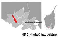 | |
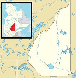 Saint-Edmond-les-Plaines Location in Saguenay–Lac-Saint-Jean Quebec. | |
| Coordinates: 48°54′N 72°33′W / 48.900°N 72.550°WCoordinates: 48°54′N 72°33′W / 48.900°N 72.550°W[1] | |
| Country |
|
| Province |
|
| Region | Saguenay–Lac-Saint-Jean |
| RCM | Maria-Chapdelaine |
| Constituted | September 3, 1938 |
| Government[2] | |
| • Mayor | Rodrigue Cantin |
| • Federal riding | Roberval—Lac-Saint-Jean |
| • Prov. riding | Roberval |
| Area[2][3] | |
| • Total | 85.80 km2 (33.13 sq mi) |
| • Land | 84.15 km2 (32.49 sq mi) |
| Population (2011)[3] | |
| • Total | 390 |
| • Density | 4.6/km2 (12/sq mi) |
| • Pop (2006–11) |
|
| • Dwellings | 179 |
| Time zone | EST (UTC−5) |
| • Summer (DST) | EDT (UTC−4) |
| Postal code(s) | G0W 2M0 |
| Area code(s) | 418 and 581 |
| Website |
www |
Saint-Edmond-les-Plaines is a municipality in the Canadian province of Quebec, located within the regional county municipality of Maria-Chapdelaine. The municipality had a population of 390 as of the Canada 2011 Census.
Before November 27, 2004, it was known simply as Saint-Edmond.[4]
Demographics
Population trend:[5]
- Population in 2011: 390 (2006 to 2011 population change: -9.7%)
- Population in 2006: 432
- Population in 2001: 518
- Population in 1996: 585
- Population in 1991: 592
Private dwellings occupied by usual residents: 167 (total dwellings: 179)
Mother tongue:[6]
- English as first language: 0%
- French as first language: 100%
- English and French as first language: 0%
- Other as first language: 0%
References
- ↑ Reference number 383390 of the Commission de toponymie du Québec (French)
- 1 2 Ministère des Affaires municipales, des Régions et de l'Occupation du territoire - Répertoire des municipalités: Saint-Edmond-les-Plaines
- 1 2 "Saint-Edmond-les-Plaines census profile". 2011 Census data. Statistics Canada. Retrieved 2010-11-24.
- ↑ http://www.stat.gouv.qc.ca/publications/referenc/pdf/Modnov04.pdf
- ↑ Statistics Canada: 1996, 2001, 2006, 2011 census
- ↑ "Saint-Edmond-les-Plaines community profile". 2006 Census data. Statistics Canada. Retrieved 2010-11-24.
 |
Rivière-Mistassini | Girardville | | |
| Saint-Thomas-Didyme | |
Albanel | ||
| ||||
| | ||||
| Normandin |
| Cities & Towns | |
|---|---|
| Municipalities | |
| Parishes | |
| Villages | |
| Unorganized territories | |
| |
This article is issued from Wikipedia - version of the 11/3/2016. The text is available under the Creative Commons Attribution/Share Alike but additional terms may apply for the media files.