Cherry Valley Township, Ashtabula County, Ohio
| Cherry Valley Township, Ashtabula County, Ohio | |
|---|---|
| Township | |
|
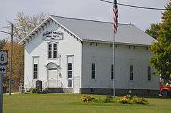
Cherry Valley's town hall | |
 Location of Cherry Valley Township in Ashtabula County | |
| Coordinates: 41°36′55″N 80°39′28″W / 41.61528°N 80.65778°WCoordinates: 41°36′55″N 80°39′28″W / 41.61528°N 80.65778°W | |
| Country | United States |
| State | Ohio |
| County | Ashtabula |
| Area | |
| • Total | 24.1 sq mi (62.3 km2) |
| • Land | 24.0 sq mi (62.1 km2) |
| • Water | 0.08 sq mi (0.2 km2) |
| Elevation[1] | 1,040 ft (317 m) |
| Population (2010) | |
| • Total | 955 |
| • Density | 40/sq mi (15.4/km2) |
| Time zone | Eastern (EST) (UTC-5) |
| • Summer (DST) | EDT (UTC-4) |
| ZIP code | 44003 |
| Area code(s) | 440 |
| FIPS code | 39-13890[2] |
| GNIS feature ID | 1085721[1] |
Cherry Valley Township is one of the twenty-seven townships of Ashtabula County, Ohio, United States. The 2010 census found 955 people in the township.[3]
Geography
Located in the southeastern part of the county, it borders the following townships:
- Dorset Township - north
- Richmond Township - northeast corner
- Andover Township - east
- Williamsfield Township - southeast corner
- Wayne Township - south
- Colebrook Township - southwest corner
- New Lyme Township - west
- Lenox Township - northwest corner
No municipalities are located in Cherry Valley Township.
Name and history
It is the only Cherry Valley Township statewide.[4]
It was first settled in 1818 by former New York resident Nathaniel Hubbard.[5]
Cherry Valley Township was named for the abundant cherry trees growing along a stream.[6]
Government
The township is governed by a three-member board of trustees, who are elected in November of odd-numbered years to a four-year term beginning on the following January 1. Two are elected in the year after the presidential election and one is elected in the year before it. There is also an elected township fiscal officer,[7] who serves a four-year term beginning on April 1 of the year after the election, which is held in November of the year before the presidential election. Vacancies in the fiscal officership or on the board of trustees are filled by the remaining trustees. Currently, the board is composed of chairman Mark Savel and members Robert Gale and Jeff Smith.[5]
Notable people
- General Leonard Wright Colby (1846-1924)
References
- 1 2 "US Board on Geographic Names". United States Geological Survey. 2007-10-25. Retrieved 2008-01-31.
- ↑ "American FactFinder". United States Census Bureau. Archived from the original on 2013-09-11. Retrieved 2008-01-31.
- ↑ "Geographic Identifiers: 2010 Demographic Profile Data (G001): Cherry Valley township, Ashtabula County, Ohio". U.S. Census Bureau, American Factfinder. Retrieved July 8, 2013.
- ↑ "Detailed map of Ohio" (PDF). United States Census Bureau. 2000. Retrieved 2007-02-16.
- 1 2 Ashtabula County, Ohio Ashtabula County, 2007. Accessed 2007-05-28.
- ↑ Kilbourn, John (1833). The Ohio Gazetteer, or, a Topographical Dictionary. Scott and Wright. p. 123. Retrieved 12 December 2013.
- ↑ §503.24, §505.01, and §507.01 of the Ohio Revised Code. Accessed 4/30/2009.
External links
Municipalities and communities of Ashtabula County, Ohio, United States | ||
|---|---|---|
| Cities | 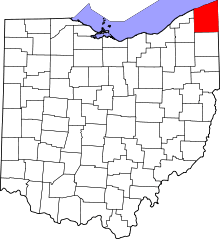 | |
| Villages | ||
| Townships | ||
| CDPs | ||
| Unincorporated communities | ||