Chamba State
| Chamba State चम्बा रियासत | ||||||
| Princely State of British India | ||||||
| ||||||
| ||||||
 | ||||||
| History | ||||||
| • | Established | ca 550 | ||||
| • | Accession to the Indian Union | 1948 | ||||
| Area | ||||||
| • | 1892 | 8,099 km2 (3,127 sq mi) | ||||
| Population | ||||||
| • | 1892 | 115,773 | ||||
| Density | 14.3 /km2 (37 /sq mi) | |||||
| Today part of | Himachal Pradesh, India | |||||
| Chamba Princely State | ||||||


..jpg)
Chamba State[1] was one of the oldest princely states in present-day Republic of India, having been founded during the late 6th century. It was part of the States of the Punjab Hills of the Punjab Province of British India from 1859–1947. Its last ruler signed the accession to the Indian Union of 15 April 1948.
Geography
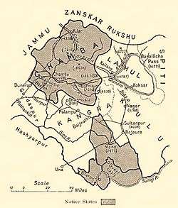
Chamba State is situated in the bosom of the Himalaya Mountains, and its boundaries are on the northwest, west, and northeast Kashmir; on the east, Lahaul; and on the southeast and south, the districts of Kangra and Gurdaspur.
The Ravi River flows through this district, and many hydroelectric generating stations have been developed here.
History
According to tradition Chamba state was founded around 550 AD. In 900 the capital was moved to Chamba. The rulers of Chamba State patronized artists of the Pahari painting style.[2] Between 1809 and 1846 Chamba was tributary to Jammu. In 1821 Chamba annexed Bhadrawah State. On 9 Mar 1846 Chamba State became a British protectorate.[3]
Rulers
The rulers of Chamba princely state belonged to the Mushana Rajput Dynasty.[4]
Rajas
- 1690 - 1720 Udai Singh (b. ... - d. 1720)
- 1720 - 1735 Ugar Singh
- 1735 - 1748 Dalel Singh
- 1748 - 1764 Umed Singh
- 1764 - 1794 Raj Singh (b. 1755 - d. 1794)
- 1794 - 1808 Jit Singh (b. 1775 - d. 1808)
- 1808 - 1844 Charhat Singh (b. 1803 - d. 1844)
- 1844 - 1870 Shri Singh (b. 1839 - d. 1870)
- 1870 - Apr 1873 Gopal Singh (b. 18... - d. 1893)
- 17 Apr 1873 - 22 Jan 1904 Sham Singh (b. 1866 - d. 1905)
- 22 Jan 1904 - 22 Sep 1919 Bhuri Singh (b. 1869 - d. 1919)
- 22 Sep 1919 - 7 Dec 1935 Ram Singh (b. 1890 - d. 1935)
- 7 Dec 1935 - 15 Aug 1947 Tikka Lakshman Singh (b. 1924 - d. 1971)[5]
See also
Further reading
- The Princely and Noble Families of the Former Indian Empire: Himachal Pradesh V. 1, by Mark Brentnall. Published by Indus Publishing, 2006. ISBN 81-7387-163-9.
References
- ↑ "Imperial Gazetteer2 of India, Volume 10, page 130 -- Imperial Gazetteer of India -- Digital South Asia Library". Retrieved 11 March 2016.
- ↑ Hindu Hill Kingdoms V&A Museum.
- ↑ "Indian Princely States A-J". Retrieved 11 March 2016.
- ↑ Abhinay Rathore. "Chamba". Rajput Provinces of India. Retrieved 11 March 2016.
- ↑ "Indian states before 1947 A-J". Retrieved 11 March 2016.
External links
 Media related to Chamba State at Wikimedia Commons
-
 "Chamba". Encyclopædia Britannica (11th ed.). 1911.
Coordinates: 32°34′12″N 76°7′48″E / 32.57000°N 76.13000°E