Banganapalle State
| Banganapalle State బనగానపల్లె | |||||
| Princely State | |||||
| |||||
|
Flag | |||||
 | |||||
| History | |||||
| • | Established | 1665 | |||
| • | Accession to the Union of India | 1948 | |||
| Area | |||||
| • | 1901 | 712 km2 (275 sq mi) | |||
| Population | |||||
| • | 1901 | 32,279 | |||
| Density | 45.3 /km2 (117.4 /sq mi) | ||||
| Today part of | Andhra Pradesh, India | ||||

Banganapalle State was one of the princely states of India during the period of the British Raj. The state was founded in 1665 and had its capital in Banganapalle. Its rulers were Shia Muslims and the last one signed the accession to the Indian Union on 23 February 1948.[1]
History
The fortified village of Banganapalle emerges from obscurity in 1601, when Sultan Ismail Adil Shah of Bijapur is recorded to have displaced the previous ruler, Raja Nanda Chakravarthy, and taken possession of the fortress. Several decades later, Banganapalle was part of a large province which the Sultan of Bijapur placed under the control of his trusted general, Siddi Sambal. The Siddi, a man of African extraction, is credited with having significantly improved the fortifications of Banganapalle.
In 1665, Sultan Adil Shah II of Bijapur granted Banganapalle and the surrounding areas as a Jagir (fiefdom) to Muhammad Beg Khan-e-Rosebahani, as a reward for services rendered. Rosebahani died without male heirs, and left the estate in the control of his adopted son and namesake, Muhammad Beg Khan Najm-i-Sani, entitled Faiz Ali Khan Bahadur. Faiz Ali and his brother Fazl Ali were officers under the Bijapur Sultan, and had come into contact with Rosebahani in that capacity. According to some sources, Faiz Ali was the son of a daughter of Rosebahani. In either case, the inheritance was not strictly legal, but the times were very unstable, and control was more important than legal niceties. In 1686, the Sultanate of Bijapur was extinguished after being defeated by the Mughals under Aurangzeb. By a fortuitous coincidence, Aurangzeb's viceroy of the Deccan, Mubariz Khan, was none other than a maternal uncle of Faiz Ali Khan. The fief of Banganapalle was secured to Faiz Ali Khan by the intervention of Mubariz Khan.
However, Faiz Ali Khan also died with surviving male issue
Banganapalle was ruled by the descendants of Faiz Ali Khan initially as a fief of the Mughal empire, and after the Nizam of Hyderabad declared his independence from the Mughals in 1724, as a fief of Hyderabad. Faiz Ali Khan also died without a male heir, and Banganapalle was inherited by his grandson, Husain Ali Khan. Toward the end of Husain Ali Khan's reign, Hyder Ali of Mysore was expanding his power in the region, and Husain Ali Khan switched his allegiance to Hyder Ali. Husain Ali Khan died in 1783, and his young son, Ghulam Muhammad Ali, succeeded him, with his paternal uncle as regent. Within the space of a year, Hyder's successor Tipu Sultan had driven them from Banganapalle; they took refuge in Hyderabad, returning to reclaim Banganapalle in 1789. Shortly thereafter, the nearby jagir of Chenchelimala was acquired by the Nawab of Banganapalle through marriage.
Banganapalle became a princely state of British India in the early 19th century. The British governor of the Madras Presidency twice took over the administration of the state for financial mismanagement, the first time from 1832 to 1848, and the second time for a few months in 1905.
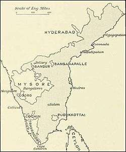
In 1901, the princely state of Banganapalle had a population of 32,264 and an area of 660 km² (255 sq. mi.).
In 1948, the ruler of Banganapalle acceded to newly independent India, and Banganapalle was incorporated into Kurnool district of the then Madras Presidency. In 1953, the northern districts of Madras State, including Kurnool District, became the new state of Andhra, which in 1956 became Andhra Pradesh
Rulers
Between c. 1665 and 1876 the rulers of Banganapalle State had the title "Kiladar".[2]
Kiladars
- 1665 - 1686 Muhammad Beg Khan (d. c.1686)
- 1686 - 1725 Muhammad Beg Khan-i-lung (d. 1725)
- 1725 - 1728 Ata Khan (d. 1728)
- 1728 - 1737 Fazil `Ali Khan I (d. 1737)
- 1737 - 1769 Fazil `Ali Kahn II (d. 1769)
- 7 Apr 1769 – 26 Aug 1783 Saiyid Husain Ali Khan (d. 1783) (personal style Khan Bahadur)
- 1784 - 1790 Muhammad Yusuf -Mysore Administrator
- 1790 - 1814 Mozaffar al-Molk Asad `Ali Khan - jointly with following:
- 1790 - 8 Sep 1822 Gholam `Ali Khan I (d. 1825)
- 8 Sep 1822 - 1831 Hosayn `Ali Khan (1st time) (d. 1848)
- 12 Jul 1848 - 1848 Hosayn `Ali Khan (2nd time) (s.a.)
- 1848 - 7 Oct 1868 Gholam Mohammad `Ali Khan II (d. 1868)
- 7 Oct 1868 – 24 Jan 1876 Fath `Ali Khan (b. 1849 - d. 1905)
Nawabs
- 24 Jan 1876 – 21 Apr 1905 Fath `Ali Khan (s.a.)
- 21 Apr 1905 – 22 Jan 1922 Gholam `Ali Khan III (b. 1874 - d. 1922)
- 21 Apr 1905 – 12 Dec 1908 John Chartres Molony -Regent (b. 1877 - d. 1948)
- 22 Jan 1922 – 15 Aug 1947 Fadli `Ali Khan III (b. 1901 - d. 1948) (forced to reside outside state 1939-1947)
See also
References
Coordinates: 15°19′00″N 78°14′00″E / 15.3167°N 78.2333°E