Morvi State
| Morvi State મોરબી રિયાસત | |||||
| Princely State of British India | |||||
| |||||
|
Flag | |||||
 | |||||
| History | |||||
| • | Established | 1698 | |||
| • | Indian independence | 1948 | |||
| Area | |||||
| • | 1931 | 627 km2 (242 sq mi) | |||
| Population | |||||
| • | 1931 | 42,602 | |||
| Density | 67.9 /km2 (176 /sq mi) | ||||
| | |||||

.jpg)
Morvi State, also spelt as Morvee State or Morbi State, was a princely salute state in the historical Halar prant (district) of Kathiawar during the British Raj. The town of Morvi (Morbi), Gujarat, was its capital.
The state's last ruler signed the accession to the Indian Union on 15 February 1948.[1]
History
Morvi was founded as a princely state around 1698 by Kanyoji when the heir apparent of Cutch State fled Bhuj with his mother after his father Ravaji was murdered and the throne was seized by his uncle Pragmalji I.[2][3] It became a British protectorate in 1807..[4] The state was in the colonial sway of the Kathiawar Agency of the Bombay Presidency.
In 1943, with the implementation of the 'attachement scheme', Morvi State enlarged its territory by an additional 310 km² with about 12,500 inhabitants when the Hadala Taluk and the Kotda-Nayani Thana, as well as the small Malia princely state were merged.
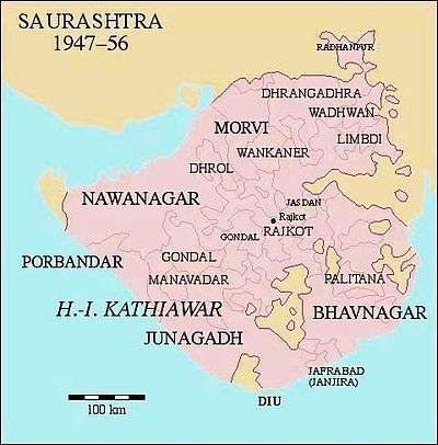
On 15 August 1947 the state ceased to exist by merging into the west Indian United State of Saurashtra (initially - of Kathiawar), which later merged into Bombay state; since that was split up, it's in Gujarat.
Rulers
The rulers of the state bore the title Thakur Sahib untill the last added the higher title Maharaja in 1926. Morvi State was ruled by the senior-most branch of the Jadeja dynasty of Rajputs.[5]
They were entitled to a Hereditary gun salute of 11-guns.
Thakur Sahibs
- 1698 - 1733 Kanyoji Rawaji (of Kutch) (d. 1733)
- 1733 - 1739 Aliyaji Kanyoji (d. 1739)
- 1739 - 1764 Rawaji Aliyaji I (d. 1764)
- 1764 - 1772 Pachanji Rawaji (d. 1772)
- 1772 - 1783 Waghji I Rawaji (d. 1783)
- 1783 - 1790 Hamirji Waghji (d. 1790)
- 1790 - 1828 Jyaji Waghji (d. 1828)
- 1828 - 1846 Prithirajji Jyaji (d. 1846)
- 1846 - 17 February 1870 Rawaji II Prithirajji (b. 1828 - d. 1870)
- 17 February 1870 - 11 July 1922 Waghji II Rawaji (b. 1858 - d. 1922) (personal style Maharaja from 16 February 1887) (from 30 June 1887, Sir Waghji II Rawaji)
- 17 Feb 1870 - 1 Jan 1879 Regents (Council of administration)
- - Shambhuprasad Laxmilal
- - Jhunjhabai Sakhidas (to 187.)
- 11 July 1922 - 3 June 1926 Lakhdirji Waghji (see below) (b. 1876 - d. 1957)
Thakur Sahib Maharaja
- 3 June 1926 - 15 August 1947 Lakhdirji Waghji (s.a.) (from 1 Jan 1930, Sir Lakhdirji Waghji)
See also
References
External links and Sources
-
 Media related to Morvi State at Wikimedia Commons
 - WorldStatesmen - India - Princely State K-Z, with flags
Coordinates: 22°49′N 70°50′E / 22.82°N 70.83°E