Brinscall
| Brinscall | |
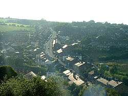 Brinscall viewed from "Brinsky Woods" |
|
 Brinscall |
|
| Population | 1,431 [1] |
|---|---|
| OS grid reference | SD625215 |
| Civil parish | Withnell |
| District | Chorley |
| Shire county | Lancashire |
| Region | North West |
| Country | England |
| Sovereign state | United Kingdom |
| Post town | CHORLEY |
| Postcode district | PR6 |
| Dialling code | 01254 |
| Police | Lancashire |
| Fire | Lancashire |
| Ambulance | North West |
| EU Parliament | North West England |
| UK Parliament | Chorley |
|
|
Coordinates: 53°41′17″N 2°34′08″W / 53.688°N 2.569°W
Brinscall is a village in the borough of Chorley, Lancashire, England. Located approximately five miles north-east of Chorley, Brinscall borders the similar-sized villages of Withnell and Abbey Village. Brinscall is part of the civil parish of Withnell but does not have its own boundaries. However, an area used in the 2001 census that covers approximately the same area as the village has a population of 1,431.
Origin of the name
A number of origins of the name ‘Brinscall’ have been suggested, one being ‘burnt huts’.[2]
History
The village was originally a small farming community, but in the 19th century, the thriving cotton industry moved in. There is also a quarry nearby, and Brinscall housed many of its workers.
The village also lends its name to an important geological feature, the 'Brinscall Fault', which is orientated approximately north-south and borders the western edge of Anglezarke moor.
Amenities
Amenities in Brinscall include:
- A small swimming pool, opened in 1911[3]
- A joint Church of England and Methodist primary school (Brinscall St John's C. E. Methodist Primary School)
- A Church of England church (St. Luke's)[4]
- A Methodist church (Hillside)[5]
- A [Premier] convenience store
- A small Post Office
- A fish and chip shop
- A tea-room serving snacks, cakes and drinks
- Croft Lodge, a pond popular with local anglers
- An athletic club with tennis courts, bowling green, cricket and football pitches
- Children's play area
- Two public houses
There is a nature trail which goes through Brinscall and many of the bordering villages. There is a large wood named by villagers as 'Brinsky Woods'. In April 2012 the BBC programme Countryfile featured the story of the lost farms of Brinscall moor, numbering about 50. The tenant farmers were encouraged to move out when the land was acquired under compulsory purchase order, in the 1902, by the Liverpool Corporation Water Works, which needed to secure a source of pure drinking water. The Corporation proceeded to plant trees across large areas of land om the moor. This deliberate afforestation effectively removed the pasture for the farms' sheep grazing and by the 1930s all the farms had been deserted.[6]
Brinscall also has a small village football team called Brinscall Village which competes in a local footballing league with several other clubs from the area.
References
- ↑ "2001 Census: Census Area Statistics: Key Figures: Area: Chorley 002D (Lower Layer Super Output Area)". Office for National Statistics. Retrieved 2008-06-21.
- ↑ Mills, David (1976). The Place Names of Lancashire. Batsford. p. 67. ISBN 0-7134-5236-6.
- ↑ "Parents fear plug pulled on baths". BBC News. 2004-05-01. Retrieved 2008-06-21.
- ↑ "Lancashire OnLine Parish Clerk Project - Parish of Withnell". Lan-opc.org.uk. Retrieved 2014-02-11.
- ↑ "Hillside Methodist Church". Hillside-methodist.org.uk. Retrieved 2014-02-11.
- ↑ "Countryfile - 08/04/2012" at bbc.co.uk
External links
![]() Media related to Brinscall at Wikimedia Commons
Media related to Brinscall at Wikimedia Commons