Coppull
| Coppull | |
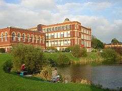 Coppull Mill and Coppull Lodge |
|
 Coppull |
|
| Population | 7,959 (2011 Census) |
|---|---|
| OS grid reference | SD562140 |
| Civil parish | Coppull |
| District | Chorley |
| Shire county | Lancashire |
| Region | North West |
| Country | England |
| Sovereign state | United Kingdom |
| Post town | CHORLEY |
| Postcode district | PR7 |
| Dialling code | 01257 |
| Police | Lancashire |
| Fire | Lancashire |
| Ambulance | North West |
| EU Parliament | North West England |
| UK Parliament | Chorley |
|
|
Coordinates: 53°37′12″N 2°39′40″W / 53.620°N 2.661°W
Coppull is a village and civil parish in Lancashire, England. It is part of the Borough of Chorley, lies around 300 feet (91 m) above sea level. Its population is around 8,000, having been counted at 7,959 in the 2011 Census.[1] It is bounded by Whittle Brook, Clancutt Brook, the River Yarrow, Eller Brook, Hic-Bibi Brook and Stars Brook. Coppull is located between Chorley and Standish, Greater Manchester, to the east of the A49 road near Charnock Richard. Coppull has been represented on Chorley Borough Council since 2011 by Cllrs Matthew Crow and Robert Finnamore and one other Councillor.
History
It is possible that a Roman road between Wigan and Walton le Dale passed over Coppull Moor according to the Chorley and District Historical and Archaeological Society after excavating a site there in 1959 and 1985.[2]
The settlement has an Anglo Saxon name describing its topography derived from the Old English copp a hill top and hyll a hill.[3] The township was variously recorded as Cophull and Cophulle in 1277, Copphull in 1351, Copthull in 1374 and Coppull from 1444.[4]
The township was originally held by the lords of Worthington until the manor of Coppull was granted to a family of that name under them. Richard of Coppull granted land to Burscough Priory. In the reign of Edward IV, Sir Thomas Stanley bought the manor and it descended with the Stanley property at Lathom until 1600 when William, Earl of Derby sold it to Edward Rigby of Duxbury. In 1755 the owners were named Livesey and John Hodson of Ellerbeck bought it in 1820.[4] The Worthingtons were recussants who kept the old faith, Roman Catholicism. Thomas Worthington became a priest at the English College, Douai and was sent to the Tower in 1584.[4]
Chisnall was held by a family of that name. Roger and John de Chisnall are mentioned in 1277 and 1292. Roger de Chisnall settled land and property on Roger and his brothers Robert, John and Thomas in 1347. John Chisnall, when he died in 1525, held land and property in Coppull and Worthington of the Earl of Derby. Richard Worthington was a Member of Parliament for Wigan between 1688 and 1689 and sat for Preston as a Tory in 1690. Blainscough belonged to the Worthingtons who lived there until after the Civil War.[4]
Industrial Revolution
A water mill at Birkacre was leased by Richard Arkwright for cotton spinning in 1778 but was set on fire by machine wreckers in 1779.[5] The mill was rebuilt and used for calico printing, dyeing and bleaching. Water power replaced by steam. Birkacre Colliery[6] opened in 1880 to supply the works which employed more than 800 people in 1883. The works and colliery closed in the 1930s and many of the buildings demolished in the 1960s.[7]
The North Union Railway between Wigan and Preston opened in 1838. Coppull Colliery was owned by John Hargreaves. On 20 May 1852 was an explosion of firedamp, found to be caused by a lighted candle, 90 men suffering from chokedamp or burns escaped but 36 men and boys died.[8] The colliery was renamed Hic Bibi Colliery[lower-alpha 1] in the 1860s. It had several owners and after it closed in the 1880s, fireclay was used at a brickworks started and operated by the Ellerbeck Collieries Company until it closed in 1959. Chisnall Hall Colliery on Coppull Moor was owned by Pearson and Knowles Coal and Iron Company in 1896 when it employed 135 underground and 48 surface workers.[10] After 1850 Coppull grew rapidly, many rows of houses were built to house coal miners and factory workers. There were several collieries and deep shafts were sunk for the John Pit, Springfield Pit, Blainscough, Hic Bibi, Darlingtons, Ellerbeck Colliery, Birkacre and Pearsons mines. Mineral lines carried coal tubs to the main railway.
Two large red brick spinning mills, Coppull Mill in 1906, and Mavis Mill were built in the early 20th century. Coppull Mill has been converted for other uses and is a Grade II listed building.[11] The last surviving collieries were Chisnall Hall and Ellerbeck.[12]
Governance
Coppull is located within the Borough of Chorley and is represented by Labour Councillors Robert Finnamore, Matthew Crow, Richard Toon and Labour County Councillor Steve Holgate.
Coppull was a township[13] in the ecclesiastical parish of St Wilfrid, Standish in the Hundred of Leyland.[14] It was a member of the Chorley Poor Law Union formed in 1837 that took responsibility for the administration and funding of the Poor Law.[15]
Economy
Since the decline in manufacturing and the end of the coal industry, the village has been converted into a satellite town for commuters to Chorley and Wigan. Notable industries today include The Yew Tree Dairy, Morris's Bakery and Staveley's egg producer.
Transport
Intersecting the village is the B5251 road, which connects Chorley to the Wigan-Preston Road. The village's closest motorway connections are the M6 Junction 27 at Standish and the M61 Junction 8 at Chorley.
Coppull is served by regular Arriva bus services to Wigan and Chorley Interchange and Stagecoach bus services to Chorley. Network Chorley service operates within the village.
The village was once served by the Blackpool to Liverpool Line stopping at Coppull railway station but this stop was terminated in 1969. Recently there has been a campaign from locals regarding re-opening the station.
Religion
There was a chapel in Coppull before the Reformation. After it fell into ruin, it was replaced in 1654 and was probably served from the parish church in Standish but was later used by Presbyterians. It was closed in 1715 and secured for the Church of England. A grant from Queen Anne's Bounty in 1716 led to the appointment of a perpetual curate. It was rebuilt in 1758 and again in 1861.[4][16]
The village has several places of worship,[17] Coppull Parish C of E Church, St John the Divine C of E Church,[18] St Oswald's Roman Catholic Church,[19] Spendmore Lane Methodist Church[20] and Preston Road Methodist Church.
Sport
Owing to Coppull's coal mining history and proximity to Wigan, the sport of rugby league has had a strong presence in the village. Chorley Panthers is a successful youth and amateur club based at Chisnall playing fields. Coppull is also home to Coppull United F.C., whose president is Bert Wilkinson.[21]
An amateur boxing club is based at Coppull Mill.
Coppull also has a long tradition or Martial Arts with both Karate and Kung Fu clubs in the district. Red Sun Shotokan Karate Club has been based at St. John's Church Hall in Coppull since 1986 and was founded by P.A.J. Handyside, 8th Dan.[22]
Coppull Kung Fu Club is based at Coppull Leisure Centre.
See also
References
Notes
- ↑ "Hic Bibi", Latin for "here drink I" was the name given to a well from which Oliver Cromwell was supposed to have drunk on a lane that now carries the name.[9]
Footnotes
- ↑ "Civil Parish population 2011". Retrieved 15 January 2016.
- ↑ Roman Roads, Lancashire County Council, retrieved 26 September 2012
- ↑ Mills 1998, p. 96
- 1 2 3 4 5 William Farrer and J Brownbill (editors) (1911), "Coppull", A History of the County of Lancaster: Volume 6, Victoria County History, British History Online, pp. 224–229, retrieved 24 September 2012
- ↑ Richard Arkwright - Biography, Lancashire County Council, retrieved 26 September 2010
- ↑ Birkacre Colliery Co. Ltd, Durham Mining Museum, retrieved 26 September 2012
- ↑ Yarrow Valley - a history, Chorley Council, retrieved 26 September 2010
- ↑ Coppull, Lancashire. 20th. May, 1852. (PDF), cmhrc.co.uk, p. 23, archived from the original (PDF) on 13 June 2010, retrieved 26 September 2012
- ↑ Welcome To Hic Bibi Local Nature Reserve, Chorley Council, retrieved 26 September 2010
- ↑ North and East Lancashire's Mining Industry in 1896, projects.exeter.ac.uk, retrieved 26 September 2012
- ↑ Historic England, "Coppul Ring Mill (1362173)", National Heritage List for England, retrieved 26 September 2012
- ↑ North Western Division Map 89, cmhrc, retrieved 26 September 2010
- ↑ Coppull Township Boundaries, GenUKI, retrieved 26 September 2010
- ↑ Lewis, Samuel, ed. (1848), "Coppull", A Topographical Dictionary of England, British History Online, pp. 682–685, retrieved 26 September 2012
- ↑ Workhouse, Workhouses.org, retrieved 26 September 2012
- ↑ Chapel Lane Church of England, Coppull, GenUKI, retrieved 26 September 2010
- ↑ Coppull, GenUKI, retrieved 26 September 2010
- ↑ St John the Divine, Coppull - Church of England, GenUKI, retrieved 26 September 2010
- ↑ St Oswald, Coppull- Roman Catholic, GenUKI, retrieved 26 September 2010
- ↑ Spendmore Lane Wesleyan Methodist, Coppull, GenUKI, retrieved 26 September 2010
- ↑ "Coppull United F.C.". coppullunitedfc.co.uk. Retrieved 17 June 2013.
- ↑ "Red Sun Shotokan Karate". redsunkarate.co.uk. Retrieved 11 July 2013.
Bibliography
- Mills, A.D. (1998), A Dictionary of English Placenames, Oxford University Press, ISBN 0 19 280074 4
External links
| Wikimedia Commons has media related to Coppull. |
- A History of Coppull and local magazine for Coppull folk
- A History of Coppull by Hubert Walsh
- Coppull's history