Chorley
| Chorley | |
| — Town — | |
 Entering Chorley town centre |
|
 Chorley |
|
| Population | 34,667 (2011) |
|---|---|
| Demonym | Chorlean |
| OS grid reference | SD5817 |
| District | Chorley |
| Shire county | Lancashire |
| Region | North West |
| Country | England |
| Sovereign state | United Kingdom |
| Post town | CHORLEY |
| Postcode district | PR6, PR7 |
| Dialling code | 01257 |
| Police | Lancashire |
| Fire | Lancashire |
| Ambulance | North West |
| EU Parliament | North West England |
| UK Parliament | Chorley |
|
|
Coordinates: 53°39′11″N 2°37′55″W / 53.653°N 2.632°W
Chorley is a market town in Lancashire, in North West England.[1] It is the largest settlement in the Borough of Chorley. Chorley is located 8.1 miles (13 km) north of Wigan, 10.8 miles (17 km) south west of Blackburn, 11 miles (18 km) north west of Bolton, 12 miles (19 km) south of Preston and 19.5 miles (31 km) north west of Manchester. As in much of Lancashire, the town's wealth came principally from the cotton industry, although it also became a major market town due to its central location between four other towns.
As recently as the 1970s the skyline was dominated by numerous factory chimneys, but most have now been demolished: remnants of the industrial past include Morrison's chimney and a few other mill buildings, and the streets of terraced houses for mill workers. Chorley is the home of the Chorley cake. According to the Office for National Statistics Chorley's population increased from 31,556 during the 2001 Census to 34,667[2] in 2011[3]
History
Toponymy
The name Chorley comes from two Anglo-Saxon words, Ceorl and ley, probably meaning "the peasants' clearing".[4] Ley (also leah or leigh) is a common element of place-name, meaning a clearing in a woodland. Ceorl refers to a person of status similar to a freeman or a yeoman.
Prehistory
There was no known occupation in Chorley until the Middle Ages, though archaeological evidence has shown that the area around the town has been inhabited since at least the Bronze Age.[5] There are various remains of prehistoric occupation on the nearby Anglezarke Moor, including the Round Loaf tumulus which is believed to date from 3500 BC.[6] A pottery burial urn from this period was discovered in 1963 on land next to Astley Hall Farm and later excavation in the 1970s revealed another burial urn and four cremation pits dating from the Bronze Age.[7]
Roman period
During the Roman era a Roman road ran near Chorley between Wigan and Walton-le-Dale.[5] It is believed that Romans settled at Brindle to the north of the town, as Roman remains were discovered there in the late 1950s. Hoards dating from the Roman period have also been found at nearby at Whittle-le-Woods and Heapey.[5]
Medieval period
Chorley was not listed in the Domesday Book, though it is thought to be one of the twelve berewicks in the Leyland Hundred.[8]
Chorley was one of the southern most points of Northern England that was raided by Scotland during The Great Raid of 1322, which lead to the construction of a Peel Tower, said to have been located somewhere close to Duxburry Hall. Chorley first appears in historical records in the mid thirteenth century as part of the portion of the Croston Lordship acquired by William de Ferrers, Earl of Derby, around 1250.[9]
The Earl established Chorley as a small borough comprising a two row settlement arranged along what later became Market Street.[5] It appears that the borough was short-lived as it does not appear in a report of a commission on the Leyland Hundred in 1341.[10]
The manorial history of Chorley is complex as the manor had no single lord throughout most of this period as it had been split into moieties and was managed by several different families.[9] This led to Chorley having several manorial halls, which in this period included Chorley Hall, built in the 14th century by the de Chorley family, and Lower Chorley Hall, which was owned by the Gillibrand family from 1583 (later rebuilt in the 19th century as Gillibrand Hall).[9][11] It is believed the borough of Chorley was not a success in this period because of the lack of manorial leadership and the dispersed nature of the small population.[11]
St Laurence's Church is the oldest remaining building in Chorley and first appears in historical records when it was dedicated in 1362, though it is believed there was already an earlier Anglo-Saxon chapel on the site which was a daughter foundation of Croston Parish Church.[9][11] It is believed that the church is named after Saint Laurence, an Irish saint who died in Normandy in the 12th century, whose bones were conveyed to the church by local noble Sir Rowland Standish[12] Duxbury,[13] an ancestor of Myles Standish(a English military officer hired by the Pilgrims as military adviser for their Plymouth expedition to the New World). Sir Rowland fought in France in the company of John FitzAllan, 14th Earl of Arundel at the Battle of Battle of Agincourt.
As happened in many other instances following the dissolution of the monasteries, these relics went missing in the turmoil of the English Reformation under the rule of Henry VIII.[14]
A market was held every Tuesday in Chorley and a fair was held annually on the feast of St Lawrence since 1498.[10]
19th century to present

Chorley, like most Lancashire towns, gained its wealth from the Industrial Revolution of the 19th century which was also responsible for the town's growth. Chorley was a vital cotton town with many mills littering the skyline up to the late twentieth century. Most mills were demolished between the 1950s and 2000s with those remaining converted for modern business purposes. Today only a minority remain in use for actual manufacturing, and the last mill to stop producing textiles was Lawrence's in 2009.[15]
Also Chorley in its location on the edge of Lancashire Coalfield was vital in coal mining. Several pits existed in Duxbury Woods, the Gillibrand area and more numerously in Coppull. Chisnall Hall Colliery at Coppull was considered the biggest Lancashire pit outside of Wigan and one of many located in the Chorley suburb. The last pit in the area to close was the Ellerbeck Colliery in 1987 which was located south of Chorley, between Coppull and Adlington.
The town played an important role during the Second World War, when it was home to the Royal Ordnance Factory, a large munitions manufacturer in the village of Euxton about 2 miles (3 km) from the town centre. A smaller factory was also built near the railway line of Blackburn–Wigan in Heapey.
In the 1970s, Chorley was designated as part of Central Lancashire new town, together with Preston and Leyland. The original aim of this project was to combine the three settlements into a single city with a population of around half a million. Although this never came to pass, and the project has since been abandoned, Chorley benefited from the urban renewal commonly associated with new towns. Examples include a bypass of the town centre, and the Market Walk shopping centre.
Religion

The Church of England parish church of St Laurence, located on Union Street, has been a place of Christian worship for over 800 years.[16]
The Church of England parish church of St George, situated on St George's Street, is an important example of the work of architect Thomas Rickman, a major figure in the Gothic Revival. It was built as a Commissioners' church in 1822.[17]
St Mary's Roman Catholic Church is based in the town centre at Mount Pleasant. The parish was founded in 1847, in an chapel in Chapel Street. The land for the church was purchased in 1851 and the first building erected in 1853. It was opened in June 1853. The church can sit 750 persons. St Mary's is described as 'a jewel in the Liverpool Roman Catholic Archdiocese'. Pugin & Pugin of London and Hansom are the architects. St Mary's bells are a magnificent example. They are recorded to be the eighth biggest set of Catholic bells, weighing a ton. The eight bells were blessed and each bell had the rite of baptism with its own name in 1894.
Chorley United Reformed Church[18] is home to one of the oldest and largest United Reformed Churches in the north west. Founded in 1792 as an Independent Church it later affiliated to the Congregational church and in 1972 voted to become part of the new United Reformed Church (URC).
The church enjoys extensive youth work, with two church youth groups affiliated to the URC's youth fellowship FURY, and a Junior Church together with Beavers, Cubs, Scouts, Rainbows, Brownies and Guides. During 2012 the church became the first church to advertise from the air when a very large cross was painted on the church car park. The cross is now visible on earth mapping websites such as Google Earth. The church has a large puppeteer team and music and drama are a regular part of church services.
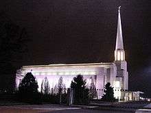
In 1998, Chorley saw the completion of the largest Latter-day Saints temple in Europe. Known as the Preston England Temple, it is a prominent landmark next to Junction 8 of the M61 motorway
Chorley's only mosque[19] is to be found on the corner of Brooke Street and Charnock Street. In March 2006, the building officially opened, having been in planning for over three years.[20][21]
Governance
In 1837, Chorley joined with other townships (or civil parishes) in the area to become head of the Chorley Poor Law Union which took responsibility for the administration and funding of the Poor Law in the area.[22] Chorley became incorporated as a municipal borough in 1881, and was governed by a mayor and council of eight aldermen and twenty four councillors.[23]
The population of the Municipal Borough of Chorley remained roughly static in the 20th century, with the 1911 census showing 30,315 people and the 1971 census showing 31,665. Under the Local Government Act 1972, Chorley became the core of a larger non-metropolitan district on 1 April 1974. The present Borough of Chorley has forty-seven councillors, representing twenty electoral wards.
The Member of Parliament for the constituency of Chorley, since 1997, is Lindsay Hoyle of the Labour Party. He has been Chairman of Ways and Means and Deputy Speaker since June 2010.
Geography

The principal river in the town is the Yarrow. The Black Brook is a tributary of the Yarrow. The name of the River Chor was back-formed from "Chorley" and runs not far from the centre of the town, notably through Astley Park.
Chorley is located at the foot of the West Pennine Moors and is overlooked by Healey Nab, a small hill which is part of the West Pennine Moors. It is the seat for the Borough of Chorley which is made up of Chorley and its surrounding villages. Chorley had a population of 33,424 at the 2001 census, with the wider borough of Chorley having a population of 101,991. Chorley forms a conurbation with Preston and Leyland and was once proposed as being designated part of the Central Lancashire New Town under the New Towns Act,[24] a proposal which was eventually scaled back.[25]
Economy


The first signs of industry as with many towns in Lancashire was mining, evidence of which can be seen by the various abandoned quarries on the outskirts of the town. One of the most beautiful of these is Anglezarke Quarry, between Chorley and Horwich. Remnants of mining include an old railway bridge from the Duxbury Mine on Wigan Lane. Eventually the mining industry was replaced by cotton mills.
Manufacture of trucks was inherited from the neighbouring town of Leyland. A large factory on Pilling Lane produced, including military vehicles and tanks during the Second World War.
Another major industry was the manufacture of ammunition and armaments. During the 1930s one of Britain's biggest arms factories was built at Euxton. The site known as ROF Chorley was vital in the Second World War and during that time over 40,000 people worked at the site. It is also the site where the bouncing bomb was built. The Nazis tried to bomb the site but could not find it as the roofs at the time were painted green, matching the surrounding grasslands and making it very hard to spot from a plane.
After the Second World War, production was reduced, and the final part of the site was closed in 2008 by BAE Systems.[26] A large part of the site has been redeveloped for residential and industrial use as Buckshaw Village.
Through the twentieth century, especially the latter half, Chorley suffered the loss of much of its manufacturing capacity with great losses in or the completely disappearance of its coal, textiles, motor vehicles and armaments industries.
Leyland Trucks and BAE Systems are the Central Lancashire area's largest employers at their sites in Leyland and Samlesbury respectively.
Companies with a presence in the borough are:
- BAE Systems
- Telent
- FedEx, North West depot located in the town
- CSC, two locations, one in Euxton and the other in Clayton-le-Woods, north of Chorley
- Multipart Solutions Limited, successor to the parts arm of the Leyland DAF
- Porter Lancastrian is a distinguished manufacturer of beer pumps, under the Porta brand.
- Merlin Cycles is one of the United Kingdom's longest established online bike shops and mail order specialists, based in Buckshaw Village
In 2011, Chorley Council launched an initiative, "Choose Chorley", to encourage SME's and large businesses to relocate to Chorley. The website at www.choosechorley.co.uk was launched in 2014, after the domain name was acquired from Chorley based web design agency, NRD media. The initiative offers red carpet introductions to key people in the town, financial incentives and tailored support for business growth.[27]
Retail
Chorley town centre is the main location of shopping facilities in the town. The town centre in recent years has seen the development of the new Market Walk, and the building of an new town centre supermarket of Booth's.
The town is also famous for its market heritage and is quoted as "Lancashire's market town". The outdoor market which has run for over two hundred years, takes place every Tuesday on the Flat Iron. There, is also a covered market place in the Market Square.
As well as these, Chorley has seen development out of town including retail parks, which have seen the addition of Currys and B&Q to name a few. Chorley is also home to three of the four big supermarkets, including Asda, Morrisons and Tesco. Further to this, Chorley was the starting point for the Chorley Group, with their flagship dealership Chorley Nissan.
The motor group now boasts eight dealerships across the North West, with the most recent addition appearing in the form of Chorley Fiat in Blackpool. The Chorley group are continuing to promote the Chorley name across the country and beyond. A £20 million development, Market Walk Phase Two, is planned to add four shop units, and a multi storey car park to the existing Market Walk shopping centre. As of January 2008, this is on hold until the council finds another developer.[28]
Health-care
Chorley is served by the local NHS hospital Chorley and South Ribble District General Hospital which is located on Euxton Lane in addition to a private hospital located in Euxton. The town also had another major hospital formerly on Eaves Lane before this closed in the 1990s. There was also the Heath Charnock isolation hospital on Hut Lane which dealt with infectious diseases before reverting to use for long term patients before closing in the 1990s.
Transport
Road
Chorley is bisected by the A6 Roman road which goes straight through the town centre. The town is also near to the M61 of which Junction 6 and 8 serving the town. Also the M6 motorway serves the west of the town with Junction 27 connecting the town to the motorway, Charnock Richard services on the M6 are located in Chorley Borough.
Bus

The town's bus station, Chorley Interchange, opened in 2003, replacing an older bus station also in the town centre. Bus services are provided by several operators:
- Stagecoach North West operate bus services which connect the town to Bolton, Blackburn, Leyland, Preston and Manchester and the Network Chorley routes within the borough.[29]
- Blackburn Bus Company operate the bus service between Blackburn and Chorley.
- National Express also operate a daily service from Chorley Interchange to London.
Rail

The main central railway station is Chorley railway station in the town centre. The railway station is used by:
- TransPennine Express whose line runs between Manchester Airport and Windermere and now links direct to Scotland without changing.
- Northern Manchester to Preston Line runs through Chorley and also connects the town to Bolton, Preston and Manchester.
The railway station was also served by the Wigan-Blackburn Railway line up until it was closed in 1960. The line also had stops at Heapey, Brinscall, Withnell and the White Bear railway station at Adlington.
Elsewhere in the borough there are railway stations at Euxton on the Wigan-Preston line, at Adlington and Buckshaw Village on the Manchester-Preston line, and at Croston on the Ormskirk Branch Line.
Waterways

The Leeds and Liverpool Canal runs parallel to Chorley and several marinas and locks are located on the Chorley area. Marinas along the canal include:
- White Bear Marina, Adlington
- Cowling Launch, Chorley
- Top Lock, Whittle
- Botany Brow
- Botany Bay Boatyard
- Riley Green, Hoghton
Education
Chorley is home to numerous primary schools, both council and church supported. Chorley has the following six high schools:
- Holy Cross Catholic High School
- Albany Academy
- Bishop Rawstorne CE Academy
- Parklands High School
- Southlands High School
- St. Michael's CE High School
Some independent schools are also present just outside the borough. Most Chorley children go on to attend the nearby Runshaw College in Leyland. Runshaw College has also expanded into the former administration site of ROF Chorley and is using, amongst others, the main administration building.
Lancashire College, based in Chorley, is a part of Lancashire County Council's Lancashire Adult Learning, offering a wide range of courses, a speciality being intensive residential language courses. From 1905 to 1981 the town was home to Chorley Training College (from the 1960s known as Chorley 'Day' Training College), designed by the Victorian and Edwardian architect Henry Cheers, and the town centre building now occupying this site is now Chorley Public Library.[30]
Sport


Chorley is home to the semi-professional football team, Chorley F.C., also known as the 'Magpies' due to their black and white strip. Founded as a rugby team in 1875, they switched to playing football eight years later. Since then they have had limited success, with their most memorable moments being two appearances in the second round of the FA Cup, and two seasons in the Football Conference in the late 1980s. They currently play in the National League North.
The town and surrounding boroughs boast a number of cricket clubs, with two teams taking the town's name. Chorley Cricket Club currently play in the Northern League, and were finalists in the ECB National Club Cricket Championship for three consecutive seasons from 1994 to 1996, winning the trophy on the first two occasions. Chorley St James Cricket Club are the second side in the town, competing in the Southport & District Amateur Cricket League, having been members of the Chorley League until its demise in 2005.
Chorley RUFC was founded in the early 1970s and initially their matches were on played on fields at Astley Park. Since there was no club house in the early days the team played from the Prince of Wales pub, near the town's covered market. Work started on a new clubhouse on 22 March 1984, on an area of land off Chancery Road, situated on the edge of the freshly constructed Astley Village Estate. The club currently run two senior sides and a mini section, the 1st XV playing in the RFU North Lancs 2 division.
Until 2004, Chorley had a rugby league side, Chorley Lynx, who played in league two of the national league. However, the club was forced to close in 2004 due to small crowds and the withdrawal of funding by backer Trevor Hemmings. Many of the club's players and staff joined Blackpool Panthers, operating out of nearby Blackpool.
Chorley boasts of being home to some of the country's most successful track cyclists including Olympic gold medal winners Jason Queally and Bradley Wiggins, and Paralympic silver medallist Rik Waddon. The presence of these well-known cyclists is due in part to the proximity of the town to the Manchester Velodrome. Chorley is also the home town of Paralympic gold medallist Natalie Jones.
In terms of local sporting facilities the town is home to Chorley Fitness, Lancashire's first twenty four hour health club, who has been awarded UK Fitness Centre of the Year in 2012, 2010 and 2007 at the Club Mirror and National Fitness Awards. They also boast BUPA accreditation and some of the most modern leisure facilities in Chorley.
There's also a council owned leisure centre; All Season which contains a swimming pool, sports hall, squash courts and a small fitness suite. The borough also includes other gym facilities, two other council owned leisure centres; Clayton Green and Coppull and another public swimming pool at Brinscall. The town is also home to a Next Generation fitness centre, other private pools and leisure centres, and a David Lloyd Tennis Centre.
1 mile (2 km) south of Chorley town centre is Duxbury Park municipal golf course.
The town is home to many amateur football, rugby and cricket teams. There are also several grass football pitches, bowling greens and tennis courts in the town. A public outdoor swimming, formerly as Astley Park, was demolished in the 1990s for Health and Safety reasons.
Chorley Harriers Running Club regularly compete in road, cross country, fell and athletics events. Chorley Cycling Club was formed in 2011, resurrecting a club which had disbanded around 1953. The club caters to both leisure and racing members and runs regular training and social rides on local roads.[31] Chorley JKS Shotokan Karate Club established a club in the town 2012.
Media
Chorley has two local newspapers: the weekly Chorley Guardian and the free Chorley Citizen. A British comedy television show, Phoenix Nights, cited Chorley's radio station, Chorley FM, whose slogan was "Coming in your ears". The station, based in Chorley, originally broadcast for only a few weeks, but in 2005 received a licence to broadcast from Chorley Community Centre (see Chorley FM).
Chorley is the hometown of Lee in the BBC sitcom Not Going Out.
As well as Phoenix Nights, comedian Dave Spikey based his comedy series Dead Man Weds in, and filmed most of it in, Chorley. Steve Pemberton, the creator of The League of Gentlemen, based most of its characters on folk from Adlington.
Seal Films, a local film production company, was nominated for a Royal Television Society Award for a short film in 2001. The company continue to operates in Higher Wheelton.
Culture and community

Chorley has two historical societies, the Chorley Historical and Archaeological Society and the Chorley and District Natural History Society. It also has a civic society.
Chorley Little Theatre was built as one of the town's first electric cinemas in 1910, it has been owned and operated by volunteers from Chorley Amateur Dramatic and Operatic Society (CADOS) since 1960. The society put on at least six productions a year (typically four plays, a pantomime, and a musical) and shows by Chorley Youth Theatre and big-screen films from Chorley Empire Community Cinema. It underwent refurbishment in 2010 and hosts touring comedy and music shows from old and new acts.
Astley Park, the town's urban, town centre park includes the Grade I listed, Astley Hall and also the renovated and refurbished Coach House Gallery and Walled Garden. The Coach House Gallery presents a seasonal programme of visual arts exhibitions from local and regional artists alongside an outdoor cultural events programme in the Walled Garden. These events include live music, theatre, dance and community arts events.
The Arts Partnership is a youth arts charity that operates from their own venue on Railway Street in the town centre. They run a number of arts and creative schemes with a diverse range of young people. The murals at the railway and bus stations were produced as part of projects from the registered charity.
Cedar Farm Galleries in Mawdesley houses a number of artists' studios, retail stores and a restaurant.
Places of interest
| Key | |
| | Abbey/Priory/Cathedral |
| | Accessible open space |
| | Amusement/Theme Park |
| | Castle |
| | Country Park |
| | English Heritage |
| | Forestry Commission |
| | Heritage railway |
| | Historic House |
| | Museum (free/not free) |
| | National Trust |
| | Theatre |
| | Zoo |

- Astley Park and Astley Hall

- Bank Hall
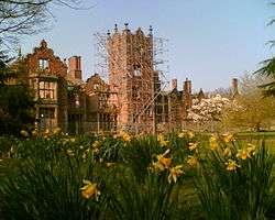 Bank Hall, Bretherton, a Jacobean mansion house, awaiting restoration. Home to Lancashire's oldest Yew tree and one of the two fallen sequoia in the UK. Open on limited open days arranged by the Bank Hall Action Group.
 - Botany Bay
- Buckshaw Village
- Preston England Temple

- Duxbury Park and Golf Course

- White Coppice & Great Hill
- Heskin Hall
- Healey Nab
- Leeds & Liverpool Canal
- Park Hall
 St George's Street and St George's Church
- Rivington Pike

- Winter Hill
- Worden Park
- Yarrow Valley Country Park
Twin towns
Chorley is twinned with:
 Székesfehérvár, Hungary[32]
Notable residents


- Loui Batley (b. 1987), (actress and dancer)
- Bill Beaumont (b. 1952), (former England rugby union captain)
- Walter Berg (b. 1947), (astronomer/astrologer)
- Leonora Carrington (1917-2011), (painter)
- Phil Cool (b. 1948), (comedian)
- C. D. Darlington (1903-1981), (biologist)
- Derek Draper (b. 1967), (former Labour spin doctor and newspaper columnist)
- John Foxx (b. 1948), (musician)
- Joseph Gilgun (b. 1984), (actor)
- Paul Grayson (b. 1971), (England rugby union player)
- Rick Guard (jazz singer and songwriter)
- Sir Walter Haworth (1883-1950), (Nobel Prize winner)
- Trevor Hemmings (b. 1935), (businessman)
- Teddy Hodgson (1885-1919), (From Chorley, played for Burnley F.C., F.A. Cup Winners against Liverpool in 1914)
- Conrad Hunte (1932-1999), (former West Indian Test cricketer, lived in Chorley before the 1957 Test Series against England)
- Charles Lightoller (1874-1952), (highest-ranking crew member to survive the RMS Titanic)
- Paul McKenna (b. 1977), (footballer)
- Paul Mariner (b. 1953), (England international footballer)
- Rifleman William Mariner VC (1882-1916), soldier awarded the Victoria Cross at Cambrin in 1915.[33]
- Barry Mason (b. 1935), (songwriter)
- Ken Morley (b. 1973), (actor)
- Phil Parkinson (b. 1967), (ex-footballer, now football manager)
- Steve Pemberton (b. 1967), (comedian)
- Jason Queally (b. 1970), (cyclist)
- Thomas Rawlinson (18th century industrialist, believed to have been born in Chorley)
- Steve Royle (comedian and radio presenter)[34]
- Kevin Simm (b. 1980), (musician, Liberty X, also winner of the fifth season of The Voice UK)
- Tom Smith (born 1985), (cricketer)
- Dave Spikey (born 1951), (comedian)
- Myles Standish (c. 1584-1656), (founder of the Pilgrim Fathers)
- Starsailor (pop group)
- Tom Criddle Stephenson (1893-1987), (journalist and champion of walkers' rights)
- Sir Henry Tate (1819-1899), (sugar magnate and founder of the Tate Gallery, London)
- Joel Tomkins (born 1987), (rugby league footballer)
- Sam Tomkins (born 1989), (rugby league footballer)
- Josh Charnley (born 1991), (rugby league footballer)
- David Unsworth (born 1973), (former footballer and current Preston North End development coach)
- Mickey Walsh (born 1954), (former Irish international footballer)
- Sir Holburt Jacob Waring Bt CBE FRCS (1866-1953), Vice-Chancellor of the University of London from 1922–24
- Rosemarie Wright (b. 1931), (pianist)
See also
References
- ↑
 Chisholm, Hugh, ed. (1911). "Chorley". Encyclopædia Britannica. 6 (11th ed.). Cambridge University Press. p. 270.
 - ↑ Evans, Jacqueline (July 2012). "Lancashire Population, 2011 Census". www.lancashire.gov.uk. Lancashire County Council. Retrieved 4 April 2016.
- ↑ The sum of the ward populations 6,823 (Chorley East), 6,651 (Chorley North East), 5,961 (Chorley North West), 6,635 (Chorley South East) and 8,597 (Chorley South West), all accessed 25 August 2015, UK Census Data.
- ↑ Institute for Name-Studies, University of Nottingham (2012). "Key to English Place-Name: Chorley". University of Nottingham. Retrieved 14 November 2012.
- 1 2 3 4 Lancashire County Council and Egerton Lea Consultancy; English Heritage and Chorley Borough Council (February 2006). Chorley: Historic Town Assessment Report (PDF). Lancashire Historic Town Survey Programme. Lancashire County Council. p. 13. Retrieved 15 November 2012.
- ↑ "Anglezarke Moor Group". The Modern Antiquarian. 2004. Retrieved 15 November 2012.
- ↑ "Astley Hall Farm Bronze Age Burial Site". The Modern Antiquarian. 26 June 2003. Retrieved 14 November 2012.
- ↑ Jim Heyes (1994). A History of Chorley. Lancashire County Books., p.6
- 1 2 3 4 William Farrer & J. Brownbill (editors) (1911). "Chorley". A History of the County of Lancaster: Volume 6. Institute of Historical Research. Retrieved 15 November 2012.
- 1 2 Lancashire County Council and Egerton Lea Consultancy; English Heritage and Chorley Borough Council (February 2006). Chorley: Historic Town Assessment Report (PDF). Lancashire Historic Town Survey Programme. Lancashire County Council. p. 1. Retrieved 15 November 2012.
- 1 2 3 Lancashire County Council and Egerton Lea Consultancy; English Heritage and Chorley Borough Council (February 2006). Chorley: Historic Town Assessment Report (PDF). Lancashire Historic Town Survey Programme. Lancashire County Council. p. 14. Retrieved 15 November 2012.
- ↑ Christopher, Tony. "Sir Rowland Standish Knight and the Holy relic of St. Lawrence.". myslesstandish.info. Chorley St Laurence Historical Society. The 1613 Visitation pedigree given to Richard St. George by Alexander Standish, Lord of the Manor of Duxbury. Retrieved 24 April 2016.
- ↑ "The Battle of Agincourt". Welcome to Standish. Standish History. Retrieved 4 April 2016.
In 1415 a John de Standysshe is recorded as being present at Agincourt. He was probably the brother of Ralph Standish, who held the Manor between 1396 and 1418. Others Standishes concerned in the French Wars were: Thomas, who fell sick at Harfleur, Sir Hugh and Christopher, both of the Duxbury branch, and Sir Rowland of Duxbury, who with his wife, Dame Jane, brought home to Chorley Parish Church some relics of St. Lawrence. There is an account which relates that Sir Rowland and Hugh Standish, each with six footmen behind him, fought at Agincourt.
line feed character in|quote=at position 433 (help) - ↑ Bolton, William (31 August 1907). "Relics of St Lawrence". The Tablet International Catholic News Weekly. Retrieved 4 April 2016.
- ↑ John Harrison 'William Lawrence's Mills, Lyons Lane, Chorley, Lancs', Chorley Historical and Archaeological Society, retrieved from http://www.chorleyhistorysociety.co.uk/w_lawrence_1_0510updt.htm on 25/04/2014.
- ↑ "stlaurencechorley2". Sites.google.com. Retrieved 31 January 2014.
- ↑ "Histroy".
- ↑ "United Reformed Church,Chorley URC,Chorley,Christian Worship in Chorley".
- ↑ "www.dawatulislam.org". www.dawatulislam.org. Retrieved 31 January 2014.
- ↑ "Special day as mosque opens". 16 March 2006. Retrieved 12 November 2016.
- ↑ "New mosque for Chorley". 23 July 2003. Retrieved 12 November 2016.
- ↑ Workhouse, Workhouses.org, archived from the original on 5 June 2011, retrieved 7 December 2010
- ↑ Farrer, William; Brownbill, J., eds. (1911). "Chorley". A History of the County of Lancaster. Victoria County History. Volume 6. British History Online. pp. 129–149. Retrieved 12 August 2016.
- ↑ "CENTRAL LANCASHIRE NEW TOWN (Hansard, 3 February 1971)". Hansard.millbanksystems.com. 3 February 1971. Retrieved 31 January 2014.
- ↑ "Central Lancashire". Centrallancscity.org.uk. Retrieved 31 January 2014.
- ↑ "Buckshaw Village plan announced". Leyland Guardian. Johnston Publishing. 26 August 2008. Retrieved 5 September 2011.
- ↑ "What's the deal?".
- ↑ "Market Walk On Hold". Chorley Borough Council. 17 January 2008. Retrieved 9 February 2008.
- ↑ "Network Chorley bus times" (PDF). Lancashire County Council. 29 November 2009. Retrieved 7 June 2011.
- ↑ "Welcome to the Library and Information Service web site - History of Chorley". Lancashire County Council. Retrieved 26 February 2008.
- ↑ Archived 9 September 2013 at the Wayback Machine.
- ↑ Bozsoki, Agnes. "Partnervárosok Névsora Partner és Testvérvárosok Névsora" [Partner and Twin Cities List]. City of Székesfehérvár (in Hungarian). Archived from the original on 8 December 2012. Retrieved 5 August 2013.
- ↑ "Home Town Recognition for William Mariner VC" (PDF). krrcassociation.com. Retrieved 17 June 2013.
- ↑ "Steve Royle makes solo debut".
External links
| Wikimedia Commons has media related to Chorley. |
| Wikivoyage has a travel guide for Chorley. |