Braden River
| Braden River | |
|---|---|
| Country | United States |
| Basin | |
| River mouth | Manatee River |
| Basin size | 83 square miles (210 km2) |
| Physical characteristics | |
| Length | 21 miles (34 km) |
The Braden River is a 21-mile (34 km) waterway that drains an 83-square-mile (210 km2) area watershed in west-central Florida and is the largest tributary of the Manatee River.
Hydrology
The hydrology of the Braden River was altered in 1936 when the city of Bradenton created Ward Lake, a reservoir with an 838-foot (255 m) broad-crested weir 6 miles (9.7 km) upstream from the mouth. In 1985 the reservoir, which is the sole source of drinking water for the city of Bradenton, was expanded and supplies an annual average of 5.7 million US gallons (22,000 m3) of water per day.[1]
The Braden River can be hydrologically divided into three distinct sections that include an 8.6-mile (13.8 km) reach of naturally incised, free-flowing channel; a 6.4-mile (10.3 km) reach of impounded river created by the Ward Lake reservoir and weir; and a 6-mile (9.7 km) reach of tidal estuary.
See also
References
- ↑ DelCharco, M.J. & Lewelling, B.R. Hydrologic Description of the Braden River Watershed, West-Central Florida. U.S. Geological Survey, 1997.
Municipalities and communities of Manatee County, Florida, United States | ||
|---|---|---|
| Cities | 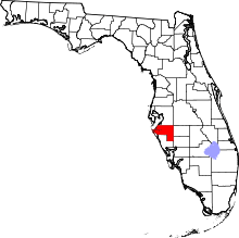 | |
| Town | ||
| CDPs | ||
| Unincorporated communities | ||
| Ghost town | ||
| Footnotes | ‡This populated place also has portions in an adjacent county or counties | |
Coordinates: 27°25′38″N 82°26′27″W / 27.4271244°N 82.4407838°W