Ellenton, Florida
| Ellenton, Florida | |
|---|---|
| CDP | |
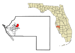 Location in Manatee County and the state of Florida | |
| Coordinates: 27°31′22″N 82°31′33″W / 27.52278°N 82.52583°WCoordinates: 27°31′22″N 82°31′33″W / 27.52278°N 82.52583°W | |
| Country |
|
| State |
|
| County | Manatee |
| Government | |
| • Type | None |
| • Mayor Mathews | City hall rep. Wood |
| Area | |
| • Total | 4.8 sq mi (12.5 km2) |
| • Land | 3.7 sq mi (9.5 km2) |
| • Water | 1.1 sq mi (3 km2) |
| Elevation | 10 ft (3 m) |
| Population (2000) | |
| • Total | 3,142 |
| • Density | 654.6/sq mi (251.4/km2) |
| Time zone | Eastern (EST) (UTC-5) |
| • Summer (DST) | EDT (UTC-4) |
| ZIP code | 34222 |
| Area code(s) | 941 |
| FIPS code | 12-20375[1] |
| GNIS feature ID | 0282171[2] |
Ellenton is a census-designated place (CDP) in Manatee County, Florida, United States. The population was 3,142 at the 2000 census. It is part of the Bradenton–Sarasota–Venice Metropolitan Statistical Area.
History
The oldest structure in Ellenton is the Gamble Plantation, which was built between 1845 and 1850 by Major Robert Gamble. Originally a sugar plantation worked by slaves, the antebellum mansion fell into disrepair after the civil war. Major George Patten and his wife, Mary, purchased the property in 1870 and named the area Ellenton after his daughter Ellen.[3] In 1881, the United States government designated Ellenton as an official post office site.[4]
Industry
January 2012 - Feld Entertainment purchased the Palmetto Corporate Center, a former Siemens Corp. complex here and plans to move most of its various operations and its world headquarters there over a five year period starting with its worldwide production center.[5]
1900 - Fuller's Earth Plant mined clay to be used as bleaching agent and as an absorbent for oil and fat.[6]
1850's to present - Agriculture was important industry, starting with sugarcane from Gamble Plantation. This was harvested through slave labor up until the Civil War. Vegetables farms and citrus groves are also important industries in Ellenton.[7]
Geography
Ellenton is located at 27°31′22″N 82°31′33″W / 27.52278°N 82.52583°W (27.522666, -82.525867).[8]
According to the United States Census Bureau, the CDP has a total area of 4.8 square miles (12 km2), of which 3.7 square miles (9.6 km2) is land and 1.1 square miles (2.8 km2) (23.70%) is water.
Demographics
As of the census[1] of 2000, there were 3,142 people, 1,386 households, and 953 families residing in the CDP. The population density was 856.7 people per square mile (330.6/km²). There were 1,676 housing units at an average density of 457.0/sq mi (176.3/km²). The racial makeup of the CDP was 91.41% White, 3.56% African American, 0.57% Native American, 0.41% Asian, 2.77% from other races, and 1.27% from two or more races. Hispanic or Latino of any race were 9.36% of the population.
There were 1,386 households out of which 22.8% had children under the age of 18 living with them, 54.8% were married couples living together, 10.5% had a female householder with no husband present, and 31.2% were non-families. 26.5% of all households were made up of individuals and 16.5% had someone living alone who was 65 years of age or older. The average household size was 2.24 and the average family size was 2.64.
In the CDP the population was spread out with 19.7% under the age of 18, 6.3% from 18 to 24, 22.7% from 25 to 44, 21.8% from 45 to 64, and 29.6% who were 65 years of age or older. The median age was 46 years. For every 100 females there were 88.6 males. For every 100 females age 18 and over, there were 84.2 males.
The median income for a household in the CDP was $32,570, and the median income for a family was $36,932. Males had a median income of $33,281 versus $22,292 for females. The per capita income for the CDP was $18,547. About 7.4% of families and 8.7% of the population were below the poverty line, including 8.1% of those under age 18 and 7.0% of those age 65 or over.
References
- 1 2 "American FactFinder". United States Census Bureau. Retrieved 2008-01-31.
- ↑ "US Board on Geographic Names". United States Geological Survey. 2007-10-25. Retrieved 2008-01-31.
- ↑ Reed, S. (2004, January). Ellenton evolves: once the home of agriculture and southern history, this Manatee community is becoming much, much more. Sarasota Magazine, 26(4), M12+. Retrieved from http://go.galegroup.com/ps/i.do?id=GALE%7CA112907042&v=2.1&u=23950_mtcpls&it=r&p=ITOF&asid=b6e270f80b9abf60428e98235431e458
- ↑ Wiggins, J. (2003). Ellenton: its early years. Kearney, NE: Morris.
- ↑ Sword, Doug; Michael Pollick (January 31, 2012). "Feld Entertainment moving headquarters to Ellenton". Herald-Tribune. Retrieved 11 May 2013.
- ↑ Wiggins, J. (2003). Ellenton: its early years. Kearney, NE: Morris.
- ↑ Wiggins, J.(2003). Ellenton: its early years. Kearney, NE: Morris.
- ↑ "US Gazetteer files: 2010, 2000, and 1990". United States Census Bureau. 2011-02-12. Retrieved 2011-04-23.
Municipalities and communities of Manatee County, Florida, United States | ||
|---|---|---|
| Cities | 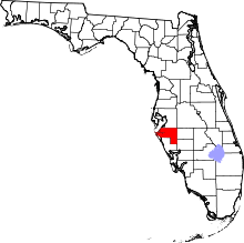 | |
| Town | ||
| CDPs | ||
| Unincorporated communities | ||
| Ghost town | ||
| Footnotes | ‡This populated place also has portions in an adjacent county or counties | |