Boxmeer
| Boxmeer | |||
|---|---|---|---|
| Municipality | |||
|
Boxmeer city hall | |||
| |||
.svg.png) Location in North Brabant | |||
| Coordinates: 51°39′N 5°57′E / 51.650°N 5.950°ECoordinates: 51°39′N 5°57′E / 51.650°N 5.950°E | |||
| Country | Netherlands | ||
| Province | North Brabant | ||
| Government[1] | |||
| • Body | Municipal council | ||
| • Mayor | Karel van Soest (VVD) | ||
| Area[2] | |||
| • Total | 113.84 km2 (43.95 sq mi) | ||
| • Land | 111.51 km2 (43.05 sq mi) | ||
| • Water | 2.33 km2 (0.90 sq mi) | ||
| Elevation[3] | 13 m (43 ft) | ||
| Population (May 2014)[4] | |||
| • Total | 28,098 | ||
| • Density | 252/km2 (650/sq mi) | ||
| Demonym(s) | Boxmeerenaar | ||
| Time zone | CET (UTC+1) | ||
| • Summer (DST) | CEST (UTC+2) | ||
| Postcode | 5440–5441, 5447, 5820–5836 | ||
| Area code | 0478, 0485 | ||
| Website |
www | ||


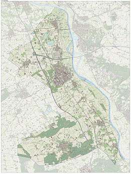
Dutch Topographic map of Boxmeer, June 2015
Boxmeer (![]() pronunciation ) is a municipality and a town in upper southeastern Netherlands. It incorporates the former municipality of Beugen en Rijkevoort and that of Vierlingsbeek. In Overloon is the Overloon War Museum.
pronunciation ) is a municipality and a town in upper southeastern Netherlands. It incorporates the former municipality of Beugen en Rijkevoort and that of Vierlingsbeek. In Overloon is the Overloon War Museum.
Population centres
- Beugen
- Boxmeer
- Groeningen
- Holthees
- Maashees
- Oeffelt
- Overloon
- Rijkevoort
- Sambeek
- Vierlingsbeek
- Vortum-Mullem
Transport
Gallery
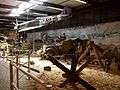 Diorama Invasion 1944, Overloon War Museum
References
- ↑ "Samenstelling College van B&W" [Members board of mayor and aldermen] (in Dutch). Gemeente Boxmeer. Retrieved 6 May 2014.
- ↑ "Kerncijfers wijken en buurten" [Key figures for neighbourhoods]. CBS Statline (in Dutch). CBS. 2 July 2013. Retrieved 12 March 2014.
- ↑ "Postcodetool for 5831JX". Actueel Hoogtebestand Nederland (in Dutch). Het Waterschapshuis. Retrieved 6 May 2014.
- ↑ "Bevolkingsontwikkeling; regio per maand" [Population growth; regions per month]. CBS Statline (in Dutch). CBS. 26 June 2014. Retrieved 24 July 2014.
External links
 Media related to Boxmeer at Wikimedia Commons
- Official website
 |
Cuijk | |
Maas / Gennep (LI) | |
| Sint Anthonis | |
Maas / Bergen (LI) | ||
| ||||
| | ||||
| Venray (LI) |

This article is issued from Wikipedia - version of the 12/1/2016. The text is available under the Creative Commons Attribution/Share Alike but additional terms may apply for the media files.