Tilburg
| Tilburg | |||
|---|---|---|---|
| City and Municipality | |||
|
Aerial view of Tilburg | |||
| |||
.svg.png) Location in North Brabant | |||
| Coordinates: 51°33′N 5°5′E / 51.550°N 5.083°ECoordinates: 51°33′N 5°5′E / 51.550°N 5.083°E | |||
| Country | Netherlands | ||
| Province | North Brabant | ||
| Government[1] | |||
| • Body | Municipal council | ||
| • Mayor | Peter Noordanus (PvdA) | ||
| Area[2] | |||
| • Municipality | 119.18 km2 (46.02 sq mi) | ||
| • Land | 117.29 km2 (45.29 sq mi) | ||
| • Water | 1.89 km2 (0.73 sq mi) | ||
| Elevation[3] | 14 m (46 ft) | ||
| Population (Municipality, May 2014; Urban and Metro, May 2014)[4][4][5][5][6] | |||
| • Municipality | 210,289 | ||
| • Density | 1,793/km2 (4,640/sq mi) | ||
| • Urban | 233,339 | ||
| • Metro | 300,249 | ||
| • Metro region | 553,706 | ||
| • Brabant CMSA | 1,932,055 | ||
| Demonym(s) | Tilburger | ||
| Time zone | CET (UTC+1) | ||
| • Summer (DST) | CEST (UTC+2) | ||
| Postcode | 5000–5049, 5056, 5070–5071 | ||
| Area code | 013 | ||
| Website |
www | ||


Tilburg [ˈtɪlbɵr(ə)x] is a landlocked municipality and a city in the Netherlands, located in the southern province of Noord-Brabant. Tilburg municipality also includes the villages of Berkel-Enschot and Udenhout. With a population of 210,289, it is the second largest city of Noord-Brabant, and the sixth largest city of the Netherlands. Its metropolitan area, which includes Goirle, has 300,249 inhabitants.
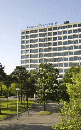
Tilburg University is located in Tilburg, as are Avans University of Applied Sciences and Fontys University of Applied Sciences.
Tilburg is known for its 10-day-long funfair,[7] the largest in the Benelux, held in July each year. The Monday during the funfair is called "Roze Maandag" (Pink Monday), and is primarily LGBT-oriented, though also enjoyed by many heterosexuals.
There are three railway stations within the municipality: Tilburg, Tilburg Universiteit and Tilburg Reeshof. The 75-hectare (185-acre) "Spoorzone" area around Tilburg Central station used to be owned by Dutch Railways as one of its national train maintenance yards. It has recently been purchased by the city and is currently being transformed into a happening urban zone, which should become an integral part of the inner city.
History
Little is known about the beginnings of Tilburg. The name "Tilburg" first appeared in documents dating from 709 AD but after that there was no mention for several centuries. In the later Middle Ages, Tilburg referred to a region rather than a particular town or village; its population was largely in a couple of hamlets, one of which was known as "Eastern Tilburg" (Oost-Tilburg), which was later reflected in the name of Oisterwijk ("Eastern Quarter"). This village centred around a small (probably wooden) castle or Motteburcht on an equally small hill, which became derelict and was torn down after a few centuries at most. Of this first "Tilburg Castle", nothing remained c. 2000, except for a few remnants of its moat in the suburbs of Oisterwijk. In the 14th century, Tilburg was proclaimed a manor; together with Goirle, it acquired the title of "The Manor of Tilburg and Goirle".
Successively, the manorial rights fell into the hands of several lords of noble lineage. They derived their income from taxes, fines and interest paid by the villagers.
In the 15th century, one of the lords of Tilburg, Jan van Haestrecht, built Tilburg Castle. "That stone chamber at Hasselt" is mentioned in several historical documents. In 1858, however, the castle was pulled down to make way for a factory, but the name lives on, in the city arms and logo. A replica of the foundations of the castle was restored in ca. 1995 in its original location, after the factory was demolished. In 1803, Goirle was separated from Tilburg and on 18 April 1809, Tilburg was granted city status. In that year, it had about 9,000 inhabitants. In 2009 Tilburg hosted several festivities in celebration of 200 years as a city.
Wool capital of the Netherlands
Tilburg grew around one of the so-called "herd places" or "Frankish triangles", triangular plots where a number of roads (usually sand roads) met. These herd places were collective pasturelands for flocks of sheep. Their shape is still reflected in the layout of many places in Tilburg. Many districts, including Korvel, Oerle, Broekhoven, Hasselt, Heikant, De Schans, and Heuvel, bear the names of these old hamlets. The poor farmers living in these hamlets soon decided not to sell the wool from their sheep but to weave it themselves, and for a long time, much of the space inside their small houses was occupied by a loom—by the 17th century these numbered about 300. Enterprising people saw their chance. As so-called "drapers" they supplied the weavers with the raw materials for their "home working", and the first Tilburg "mill houses" came into existence. From then on, the wool industry underwent rapid growth, and in 1881 Tilburg had as many as 145 woollen mills. Home weaving continued, however, until the early 20th century. Woollen textiles from Tilburg were known far and wide. After the World War II Tilburg retained its place as wool capital of the Netherlands, but in the 1960s the industry collapsed and by the 1980s the number of wool mills could be counted on the fingers of one hand. Present-day Tilburg industry consists of a wide variety of enterprises. The main economic sector has become transport and logistics with a variety of industry as a close second.
Urban renewal
At the same time as the wool industry collapsed, Cees Becht was the mayor of Tilburg. While he was in office, many buildings were destroyed, including some very precious monuments. The neighbourhood Koningswei (King's Meadows) was demolished and replaced by Koningsplein (King's Square). The old neighbourhood was some kind of slum and had to be replaced by newer development. The newer development, however, wasn't as successful as was expected, and the square feels abandoned most of the year.[8] Considered even worse was the demolition of the old city hall. This classicistic-styled building was a national-registered monument, but even that didn't prevent Becht's plans to demolish it to build the nine-storey, modern-day, black complex.[9] A part of the empty area was used to build the system of the inner Cityring.[10] Another building that was demolished was the old railway station, which was replaced due to Hoogspoor (literally: high rails), a project bringing the railway on viaducts to reduce traffic congestion in the years around 1960. The century-old station building was replaced by the modern one.[11] Because of all of this and some more parts of Tilburg, Cees Becht gained the dubious nickname Cees the Sloper (Cees the demolisher)[12]
Modern history
In the 1980s, many locations, formerly occupied by wool factories had been filled with small-scale housing projects. This mostly happened when Henk Letschert was mayor of Tilburg.[13] The Heuvel, one of the important squares, had its own lime tree until 27 April 1994, being chopped for a bicycle parking basement. The cut-down led to many protests, because the tree was still healthy. After the Pieter Vreedeplein reconstruction, plans were made to plant a descendant of the original lime tree. Three were placed, only one of them survived. The last living tree was moved to another location again,[14] but died shortly after. As of 23 November 2011, no more descendants have been placed. The current one is just another lime tree.[15] In the 1990s Tilburg developed a modern skyline. Because of new policy three buildings were build, which are considered skyscrapers in the Netherlands. These are the Interpolis headquarters, the Westpoint Tower and StadsHeer. The Westpoint Tower has an altitude of 143.1 metres (469.5 feet) and was the tallest residential tower in The Netherlands until the Montevideo in Rotterdam surpassed it. De 'StadsHeer' is the third one and is part of the 'Haestrechtkwartier' (Haestrecht quarter). The residential tower is nicknamed De Vogelkooikes (Bird cages) for its cubic balconies taped onto the building.
King William II
King William II (1792–1849) was fond of Tilburg. "Here I can breathe freely and I feel happy", he once said about the town. King William II always supported Tilburg—he provided money to improve the sheep breeding, built new farms and founded a cavalry barracks on the St. Joseph Street, now a monumental building of the City Archives. Although the King was always made welcome by the manufacturers he had befriended, he needed his own residence in Tilburg, and commissioned the construction of a palace, which would function as his country residence. Construction started in 1847 and was completed just days before William II died, in 1849. It is now part of Tilburg City Hall. In 1987 an obelisk was erected nearby, in memory of King William II. It replaced the old "needle" dating from 1874, which was removed from the street in 1968. After its restoration, William II's statue has got a place again in the heart of the city, where he felt happy among its inhabitants. The local football club Willem II Tilburg was named after the king.
Topography
Tilburg Centrum

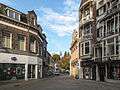
Tilburg Centrum is the downtown of Tilburg, and is situated between (clockwise) the Spoorlaan, Heuvelring, Paleisring, Schouwburgring and Noordhoekring, which is the same as the order of the one-way roads around the district. The district has 6,331 inhabitants, and most of the shops, hotels, restaurants and cafes of the city. In 2008, the refurbished Pieter Vreedeplein was opened to public, addressing a locak of shopping facilities as compared to similar-sized cities in the Netherlands. Two smaller cinemas were replaced by a bigger one on the Pieter Vreedeplein in 2007. Despite being called Centrum, the district is some distance southeast of the geographical center. The district is connected by Tilburg railway station.
Oud-Noord

Oud-Noord is situated north of the railway that crosses Tilburg, and between the Ringbanen (Ring roads around the city center). The district has 31,649 inhabitants. Contemporary arts museum De Pont is located within the district. When the railway marshalling yard belonging to the Nederlandse Spoorwegen became obsolete, a considerable stretch of the railway across the city, the Spoorzone, became an urban renewal project. New premises for two courses run by Fontys University of Applied Sciences will be located here, as will Tilburg's new central library, replacing the library in Koningsplein [16] The railway yard is the largest area, though more areas along the railway will be reconstructed.[17]
Oud-Zuid

Oud-Zuid is a district south, and also west and east of downtown Tilburg. The district has 38,659 inhabitants. As of 2012, all the 'skyscrapers' of Tilburg, higher than 100 m (330 ft) are located within the district. The Hart van Brabantlaan is almost surrounded by high buildings like Westpoint Tower and the StadsHeer as a small part of the urban renewal. This area along the railway is partly located in Oud-Zuid. Many important locations in Tilburg are located within the district, just out of the center, such as 013 music venue and the Schouwburg built in 1961. Also the Koningsplein with the main library and the Piushaven are located within the district. Old herd places include Korvel, Broekhoven and Oerle.
Noord

Tilburg-Noord is located north of the Wilhelminakanaal. The district has 22,763 inhabitants. Tilburg-Noord is built in the period 1966–1974. Therefore, it has many apartment buildings up to 16 floors, drive-in houses, green strips and industrial development. The streets in this district are mostly named after musicians from the renaissance up to pop artists from the 1960s. The main shopping center is Wagnerplein, while there's also the Verdiplein in Stokhasselt. The one at the Tartinistraat became defunct.[18] Before the district was built, it mainly was agricultural area with some villages. The most notable was Heikant, which is still the name of the biggest neighbourhood. Its former village square including the old church is still present. The northernmost part of the district is still agricultural with some forests. In this agricultural area, the blessed Peter Donders was born, there still stands a chapel and a procession park.
Oost

Tilburg-oost consists of primarily industrial development. Residential neighbourhoods are in a small strip east of the Ringbaan Oost rather than the whole district, however, is not considered as a part of the city center. The district only has 770 inhabitants.
Zuid

Tilburg-Zuid is located between the A58 motorway and the Ringbaan Zuid, and is the southernmost district. Tilburg-zuid has 14,836 inhabitants. The district contains two neighbourhoods and many businesses. The football club Willem II is located within the district, as well as the ice-skating rink with a speed skating rink, the Ireen Wüst Ijsbaan, is located here. The main campus of Fontys University of Applied Sciences is located in this district, as well as St. Elisabeth hospital and the Leijpark, one of the largest public parks in the city.
West

Tilburg-west was mostly built after WWII, and has 29,611 inhabitants. The district with its neighbourhoods consist mostly of small brick houses and apartment buildings, except for Zorgvlied, which contains more expensive, free-standing houses. The Westermarkt is the largest shopping center out of the inner city. Many higher educational buildings are standing here, like as the Tilburg University and Avans Hogeschool. Another place of many schools is along the Reitse Hoevenstraat with multiple secondary schools. The district is connected by train with the Tilburg Universiteit railway station and has one of the two hospitals in Tilburg (TweeSteden ziekenhuis). The largest mosque of Tilburg, the Turkish Süleymaniye-Mosque built in 2001, stands in the southeastern corner of the district. West is surrounded by forests like Wandelbos and the Oude Warande, located west of the university.
Reeshof

The Reeshof is the westernmost district and the most recent expansion of the city of Tilburg proper. and has a population of 42,696 inhabitants. Because of this, the Reeshof became the largest district of Tilburg. The first houses were completed in 1980, in the neighbourhood Gesworen Hoek. As of 2012, the last neighbourhood (Koolhoven Buiten) is under construction. The district is connected by Tilburg Reeshof railway station and multiple roads that encircle the district plus the industrial development Vossenberg north of the Wilhelminakanaal. The Donge runs through the district, including the nature development with some Highland cattle grazing between the fences protecting the surrounding neighbourhoods. This small-scale nature project is called the Dongevallei,[19] which literally means Donge Valley in English.
Villages of Berkel-Enschot and Udenhout
Demographics
Ethnic makeup
The population of Tilburg was 206,234 on 1 January 2011. According to the Tilburg city council, the city will reach a population of 217,000 by 2025. Of these, 23.3% (47,964 people) are of foreign descent.[20] People are classified as being of foreign descent when they were born outside of the Netherlands, or when at least one of their parents was born outside of the Netherlands.
- Dutch (158,270) (76.7%)
- Turks (7,786) (3.8%)
- Moroccans (5,483) (2.7%)
- Indonesians (5,077) (2.5%)
- Antilleans/Arubans (4,333) (2.1%)
- Surinamese (3,315) (1.6%)
- Somalis (1,159) (0.6%)
- Others (20,811) (10.1%)
Religion and life stances
The Tilburg agglomeration has the following religious makeup as of 2003:[21]
- Roman Catholic (60.7%)
- Atheism (21.7%)
- Dutch Reformed (7.8%)
- Islam (4.8%)
- Reformed (4.4%)
Geography
Climate
Tilburg experiences an oceanic climate (Köppen climate classification Cfb) similar to almost all of the Netherlands. The most notable fact from Western Brabant is that there are more thunderstorms than anywhere else in the Netherlands, up to 31 days a year.[22]
| Climate data for Gilze-Rijen, 1981–2010 normals | |||||||||||||
|---|---|---|---|---|---|---|---|---|---|---|---|---|---|
| Month | Jan | Feb | Mar | Apr | May | Jun | Jul | Aug | Sep | Oct | Nov | Dec | Year |
| Average high °C (°F) | 5.8 (42.4) |
6.6 (43.9) |
10.4 (50.7) |
14.4 (57.9) |
18.4 (65.1) |
20.9 (69.6) |
23.2 (73.8) |
23.0 (73.4) |
19.4 (66.9) |
14.9 (58.8) |
9.7 (49.5) |
6.2 (43.2) |
14.41 (57.93) |
| Average low °C (°F) | 0.0 (32) |
−0.2 (31.6) |
2.1 (35.8) |
3.8 (38.8) |
7.6 (45.7) |
10.3 (50.5) |
12.7 (54.9) |
12.2 (54) |
9.9 (49.8) |
6.7 (44.1) |
3.3 (37.9) |
0.8 (33.4) |
5.77 (42.37) |
| Average precipitation mm (inches) | 70.0 (2.756) |
57.2 (2.252) |
64.1 (2.524) |
46.0 (1.811) |
61.2 (2.409) |
65.8 (2.591) |
75.6 (2.976) |
66.0 (2.598) |
72.4 (2.85) |
75.0 (2.953) |
76.1 (2.996) |
75.8 (2.984) |
805.2 (31.7) |
| Average precipitation days (≥ 0.1 mm) | 17 | 14 | 17 | 13 | 14 | 14 | 14 | 13 | 14 | 16 | 18 | 18 | 182 |
| Average snowy days (≥ 0.1 cm) | 6 | 6 | 4 | 2 | 0 | 0 | 0 | 0 | 0 | 0 | 2 | 5 | 25 |
| Average relative humidity (%) | 88 | 84 | 81 | 75 | 74 | 75 | 76 | 77 | 82 | 86 | 89 | 90 | 82 |
| Mean monthly sunshine hours | 63.1 | 84.5 | 119.1 | 171.7 | 203.8 | 195.5 | 205.9 | 190.2 | 142.0 | 113.4 | 64.2 | 50.1 | 1,603.5 |
| Source: KNMI [23] | |||||||||||||
Economy
The economy was concentrated on wool industry for centuries, however, since the 1960s, Tilburg made more progress in having different kinds of industries, supported by the government to prevent the city from poverty after the decline of wool industry. Chemical company IFF [24] has a factory in Tilburg. In the 1980s, the Japanese company Fujifilm came in Tilburg.[25] Insurance companies like Interpolis and CZ are headquartered in Tilburg, as well as transportation/distribution industries situated in Tilburg for being the geographical center of the Benelux-countries. Iris Ohyama has its European offices in Tilburg.[26]
Education
Tilburg University
Higher education is of significant importance, with Tilburg University attracting scholars from all over the world. It has a student population of about 13,000 students, about 8 per cent of whom are international students.[27] This percentage has steadily increased over the past years.[28] TiU offers both Dutch-taught and English-taught programmes.
The institution has gained a reputation in both research and education. In the field of economics, the Faculty of Economics and Business Administration ranked #1 in Europe for the second consecutive time in 2007 according to the Journal of the European Economic Association with regard to publications in top journals.[29] In 2007 the Executive MBA program at the university's TiasNimbas Business School ranked # 11 in the world according to the Financial Times.[30] In the field of law, Tilburg University was ranked #1 in the Netherlands for the last three years according to Elsevier Magazine.[31]
Culture and recreation
Tilburg is a pilot city of the Council of Europe and the EU Intercultural cities programme.
Beverages
Schrobbelèr is a local liqueur. It has an alcoholic percentage of 21.5%, slightly lower than most bitters and has a relatively sweet flavour. The drink is sold in a stone jar and is drunk cold from own glass, a high and tiny chalice glass, larger than a Jägermeister glass [32] The drink originated in 1973 when Tilburgian entrepreneur Jan Wassing started experimenting with a drink with lower alcoholic percentage that was appropriate for his stomach. The result was successful. The drink is distilled now at Loven industrial area in Tilburg by the Eindhoven company Schrobbeler Ltd, without the è on the last vowel. The drink is especially drank at Carnival. The name is derived from the profession of 'Schrobbelaar', in the textile industry in Tilburg. The profession was unskilled and had a low wage.
Another known drink from Tilburg is Peerke's Nat, which has a higher alcoholic percentage than Schrobbelèr (25%) and is introduced at the beatification of Peter Donders (locally named Peerke). The drink is sold in bottles of 70 centiliters.
The Koningshoeven Brewery brews trappist beer. It was founded in 1884 at Koningshoeven Abbey.
Open air art

Tilburg has some notable art in the city, mostly supported by KORT (Kunst in Open Ruimte Tilburg, Dutch for Art in Open Space Tilburg).[33] The most notorious example is the turning house on the Hasseltrotonde, a roundabout,[34] mostly being criticised for being 'no art' and 'waste of money'. However, the house was erected in 2008. Except for being responsible for newer, modern art, KORT also gives information about older works of art, like the Willem II statue on the Heuvel.
Festival city, music
The city of Tilburg hosts many festivals, such as Incubate, Festival Mundial (world culture), Stranger Than Paranoia (jazz), Tilburg Students Festival, and Roadburn Festival. 013 is a modern pop-centre. Paradox is a club for experimental jazz and improvised music. Fontys University of Applied Sciences started a pop-academy in the beginning of the 21st century, and students often perform on local stages.
Museums
Tilburg has an outstanding museum of Modern Art, De Pont. There is also a large textile museum, offering not only a historical view in its former factory, but also a laboratorium for design, production and development of textile as a material. Another museum is Noordbrabants Natuurmuseum.
Parks and forests
A lot of parks and forests provide people from Tilburg area for recreation. The Leijpark and the Reeshofpark are the largest among the parks in Tilburg. The Leijpark is famous for Festival Mundial and lies next to the St. Elisabeth hospital and a monastery, the Cenakel. The Reeshofpark is created in the late 1990s, including some restaurants opened in 2011.[35] Some older parks include the Wilhelminapark in Oud-Noord, is built on the square of the former herd place Veldhoven. Tilburg offers, in comparison to other top-ten cities in the Netherlands the most forest area. In the municipality, Tilburg has the Wandelbos, a forest south of the similarly named neighbourhood in Tilburg-West, the Oude Warande, the Kaaistoep, a forest of 4.5km2, and partially, Huis Ter Heide in the northwest of Tilburg, a 6.5km2-sized natural redevelopment area. Out of the municipality, there's a national park called Loonse en Drunense Duinen which includes dunes of drift sand from the west coast.
Sports
The local football team is Willem II, named in remembrance of King William II.
Tilburg Ten Miles is an annual road running competition held in Tilburg.
Students sports like rowing and hockey are popular as well. Tilburg hosts three field hockey clubs that play in top national leagues.
Tilburg has an ice skating rink, including the speed skating rink Ireen Wüst IJsbaan of 400m. Within the speed skating rink there's an ice hockey field. The Hockey team Tilburg Trappers also does well in the Eredivisie (Dutch Premier League).
Transport
Tilburg has three railway stations: Tilburg (Centraal), Tilburg Universiteit and Tilburg Reeshof. The third of them, Station Tilburg Reeshof was built to connect the then-latest district of Tilburg, the Reeshof. Intercity trains only stop at Tilburg (centraal). The name of Tilburg Universiteit Station was from its construction in 1968 to December 2010 Tilburg West, however, after 40 years, it was not the westernmost station anymore. A fourth railway station is planned for Berkel-Enschot, also in the municipality of Tilburg and more getting absorbed by Tilburg. In the past, until 1938, Berkel-Enschot had already its own train station. Udenhout, lying further northeast in the municipality, also had its train station until 1938. Both stations are on the line to 's-Hertogenbosch.
The Tilburg city- and local buses are operated by Veolia Transport Nederland. The city experimented from 2005 to 2008 with free public transport for children and 55+-people. Before Veolia took over the bus network, it was operated by BBA (abbreviation for Brabants(ch)e Buurtspoorwegen en Autobussen).
Tilburg has an extensive bicycle path network called Sternet-Routes. The first bicycle path of this network was built between the city center and the university in 1975. From the mid-1990s, multiple bicycle paths (rather than lanes along the road) have been built. Since most of these have been paved by tiles, there is an increasing call for asphalt-paved paths. For this network of bicycle paths, there are built some new tunnels; under the railway that crosses the city.[36]
Tilburg is, at variance from other Dutch cities of a similar size, connected by only one national motorway, the A58 / E312 (to Breda and Eindhoven). An outer beltway, consisting of two provincial 2x2-roads and the A58, has been finished in May 2012.[37] Although the outer beltway is fully navigable, the Burgemeester Bechtweg, which was built initially as a two-lane (one per direction) road, will be finished in 2013. Two other routes are of considerable importance for Tilburg: the A261/N261 to Waalwijk and the A65/N65 to 's-Hertogenbosch. Neither is a complete motorway, and both experience bottlenecks. Various plans exist to build both to higher standards, with the N261 improved in 2015.[38]
International relations
Twin towns — Sister cities
Tilburg is twinned with:
|
Gallery
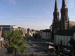
 Tilburg, view at Heuvelstraat
 Tilburg, the Saint Denis Church, known as the: Heikese Kerk
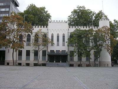 City Hall of Tilburg, called: Paleis-Raadhuis
Notable people from Tilburg
- Bart le Blanc, Vice President, European Bank for Reconstruction and Development
- Remy Bonjasky, martial artist; originally from Suriname
- Cilvaringz, rapper affiliated with Wu-Tang Clan
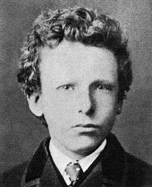
- Vincent van Gogh, attended the King Willem II school, where he was taught painting
- Theo l' Herminez (1921–1997), painter
- Henk Krol (1950), member of parliament
- Guus Meeuwis, singer-songwriter, attended Tilburg University
- Michael van Poppel, "BNO News"-founder
- Leonard Retel Helmrich, cinematographer and film director
- Bas Rutten, mixed martial artist
- Theo van de Sande, cinematographer
- Norbert Schmelzer, minister
- Cornelis van Spaendonck, still-life painter in Paris and at the Manufacture de Sèvres (miniatures on porcelain); died in
- Gerard van Spaendonck, painter
- Hennie Vrienten, musician, composer
- Floor Jansen, singer-songwriter, Nightwish
- Benito van de Pas, darts player
See also
References
- ↑ "Burgemeester Peter Noordanus" [Mayor Peter Noordanus] (in Dutch). Gemeente Tilburg. Retrieved 17 April 2014.
- ↑ "Kerncijfers wijken en buurten" [Key figures for neighbourhoods]. CBS Statline (in Dutch). CBS. 2 July 2013. Retrieved 12 March 2014.
- ↑ "Postcodetool for 5038TC". Actueel Hoogtebestand Nederland (in Dutch). Het Waterschapshuis. Retrieved 17 April 2014.
- 1 2 "Bevolkingsontwikkeling; regio per maand" [Population growth; regions per month]. CBS Statline (in Dutch). CBS. 26 June 2014. Retrieved 24 July 2014.
- 1 2 "Bevolkingsontwikkeling; regio per maand" [Population growth; regions per month]. CBS Statline (in Dutch). CBS. 26 June 2014. Retrieved 24 July 2014.
- ↑ "De grenzeloze regio". Sdu uitgevers. 2007.
Het BBP van BrabantStad ligt op 14.7% van het nationale BBP. In de regio liggen Philips, de Technische Universiteit Eindhoven, de Universiteit Tilburg en de HAS Den Bosch. De regio heeft 1.4 miljoen inwoners. Er is veel R&D, ICT, automotive, logistiek en agribusiness.
- ↑ (Dutch) Tilburgse Kermis
- ↑ "Nederlands Architectuurinstituut - Item_sos - Koningswei Tilburg". Nai.nl. Retrieved 2014-06-24.
- ↑ "Stadhuis - Tilburg Wiki" (in Dutch). Regionaalarchieftilburg.nl. 2014-02-26. Retrieved 2014-06-24.
- ↑
- ↑ "Hoogspoor - Tilburg Wiki" (in Dutch). Regionaalarchieftilburg.nl. 2013-11-26. Retrieved 2014-06-24.
- ↑ Archived 1 March 2009 at the Wayback Machine.
- ↑ "Henk Letschert - Tilburg Wiki" (in Dutch). Regionaalarchieftilburg.nl. 1975-04-16. Retrieved 2014-06-24.
- ↑ Placing the last living lime tree again in the local newspaper
- ↑ News about the lime tree replacement of 23 November 2011.
- ↑ "News about the settling institutes (Dutch, 19-01-2012)". bd.nl. Retrieved 2014-06-24.
- ↑ (Dutch) "Tilburg Spoorzone" website (Website about the Spoorzone being reconstructed).
- ↑ Tartinistraat shops getting closed for houses
- ↑ "Dongevallei-Site in Dutch". Dongevallei.nl. Retrieved 2014-06-24.
- ↑ (Dutch) "Tilburg in cijfers," Gemeente Tilburg (May 2011)
- ↑ (Dutch) "Religions of Tilburg agglomeration (including Waalwijk, Dutch)"
- ↑ (Dutch) "Where thunderstorms occur"
- ↑ "Gilze-Rijen, langjarige gemiddelden, tijdvak 1981-2010" [Gilze-Rijen, long time averages, 1981-2010] (PDF). Klimaatatlas (in Dutch). KNMI. Retrieved 18 March 2013.
- ↑ "Map of IFF locations, including the one in Tilburg". Iff.com. Retrieved 2014-06-24.
- ↑ "Fujifilm Tilburg". Fujifilmtilburg.nl. 2013-07-29. Retrieved 2014-06-24.
- ↑ Contact. Iris Ohyama Europe. Retrieved on 7 November 2010. "Iris Ohyama Europe B.V. Gesworenhoekseweg 1 5047 TM Tilburg – The Netherlands."
- ↑ "About Tilburg University," Tilburg University website
- ↑ "Annual report of Tilburg University of 2007, p. 51" (PDF). Uvt.nl. Retrieved 2014-06-24.
- ↑ Archived 5 February 2012 at the Wayback Machine.
- ↑ "FT.com / Business Education / EMBA rankings". Rankings.ft.com. 2014-06-03. Retrieved 2014-06-24.
- ↑ "Elsevier Magazine". Tilburguniversity.nl. Retrieved 2014-06-24.
- ↑ Schrobbelèr Tilburg Information about Schrobbelèr
- ↑ "Website of KORT (Dutch)". Kunstbuitenbinnentilburg.nl. 2014-03-26. Retrieved 2014-06-24.
- ↑ "About the turning house on the roundabout in Tilburg (Dutch)". Kunstbuitenbinnentilburg.nl. Retrieved 2014-06-24.
- ↑ "News about the opening of restaurants near Reeshofpark (Dutch, 2011-08-08)". bd.nl. Retrieved 2014-06-24.
- ↑ (Dutch) Hein Eikenaar "Spoor Tilburg-Breda dicht voor aanleg tunnelbak," Brabants Dagblad (19-01-2012). (Railway closed down for placing bicycle tunnel)
- ↑ "Burgemeester Letschertweg open | Stadsnieuws | dé Weekkrant". Deweekkrant.nl. Retrieved 2014-06-24.
- ↑ "Grootschalige ombouw Waalwijk Loon op Zand" (in Dutch). Brabant.nl/.
- ↑ "Miasta Partnerskie Lublina" [Lublin - Partnership Cities]. Urząd Miasta Lublin (City of Lublin) (in Polish). Archived from the original on 16 January 2013. Retrieved 7 August 2013.
External links
 |
Dongen | Loon op Zand, Heusden | Haaren | |
| Gilze en Rijen | |
Oisterwijk | ||
| ||||
| | ||||
| Goirle | Hilvarenbeek |
