Boston Harborwalk
| Boston Harborwalk | |
|---|---|
|
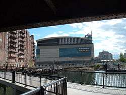
Under Charlestown Bridge in 2008. | |
| Established | 1984 |
| Length | 47 mi (76 km) |
| Location | Boston, Massachusetts |
| Trailheads | Numerous access points |
| Use | Walking, bicycling, inline skating |
| Hiking details | |
| Trail difficulty | Easy |
| Season | Year round |
| Sights | Boston Harbor |
| Hazards | Follows edges of piers, some stairs; portions of proposed route are incomplete |
| Website |
www |
Boston Harborwalk is a public walkway that follows the edge of piers, wharves, beaches, and shoreline around Boston Harbor. When fully completed it will extend a distance of 47 miles (76 km) from East Boston to the Neponset River.[1]
History
The Harborwalk is a cooperative project of the City of Boston,[2] the Boston Redevelopment Authority,[3] the Massachusetts Department of Environmental Protection,[4] The Boston Harbor Association,[1] and private property developers. Since 1984, the project has established parks, walking paths, educational sites, transportation facilities, and other amenities along the harbor. Many developers of private land along the harbor have been required under the provisions of the Boston Zoning Code[2] and of Chapter 91 of Massachusetts state law[5] to set back new buildings from the water and to provide publicly accessible waterfront pathways.[3]
A map of the proposed route[6] shows that the completed Harborwalk will consist of a continuous trail from Charlestown in the north to Dorchester in the south, plus many other discontinuous trail segments. A map[7] and trail guide[8] describe the current status of the route. An interactive map[9] highlights sights along a portion of the walk in downtown Boston. As of 2016, 38 of the originally planned 47 miles of trail have been completed.[3] Following the September 11 attacks, plans to extend the Harborwalk to the four miles of shoreline around Logan Airport were abandoned.[10] As an alternative, planners are now considering an inland route connecting the Harborwalk through the East Boston Greenway to Constitution Beach.
Connections to other trails
The Harborwalk connects with many other trails. From north to south, these include the following:
- East Coast Greenway
- East Boston Greenway
- Freedom Trail
- Charles River Bike Paths
- Millers River Trail
- Proposed extension of Somerville Community Path
- Rose Kennedy Greenway
- Walk to the Sea[11]
- South Bay Harbor Trail
- Lower Neponset River Trail
- Quincy RiverWalk[12] to Squantum Point Park
Public art
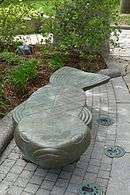
Sculptures and memorials, including some by noted artists, have been placed at many locations along the Harborwalk. Playful fish sculpture benches by Judy Kensley McKie and sculptures by Susumu Shingu and David Phillips have been created for Eastport Park, South Boston.[13] Sculptures by Tony Smith, Willem de Kooning, Luis Jimenez, Dennis Oppenheim, William G. Tucker, and Sol LeWitt are located on the University of Massachusetts Boston campus.[14] Between the Institute of Contemporary Art and the John Joseph Moakley United States Courthouse, a series of artworks by Ross Miller evoke moments in the history of Fan Pier.[15] "Untitled Landscape"[16] by David von Schlegell is located at Harbor Towers.
An interactive musical sculpture, "Charlestown Bells,"[17] by Paul Matisse (grandson of the painter Henri Matisse) is located along the walkway of the Charles River Dam. The bells were installed in 2000, but had fallen into disrepair before a 2013 restoration.[18]
Memorial sculptures found along the Harborwalk include a memorial to firefighter Robert M. Greene at Castle Island in South Boston;[19] a Korean War Memorial at Shipyard Park in the Boston Navy Yard in Charlestown;[20][21] and a United States Maritime Service memorial in the North End's Langone Park.[22]
Historical exhibitions
Along the Harborwalk are several indoor and outdoor displays of historical materials, some of which are available for view 24 hours a day. A selection from the archive of Norman B. Leventhal’s collection of Maps of Boston Harbor and Massachusetts Bay[23] is located in the lobby of the Boston Harbor Hotel.[24] In the lobby of Building 114 at the Boston Navy Yard is an exhibition of boat models, photographs and boat building tools.[25] The Maritime Museum at Battery Wharf[26] was built by the developers of the Battery Wharf Hotel[27] as "mitigation" under the state's Chapter 91 law,[5] to compensate the public for private use of waterfront land.
Notable attractions
East Boston
- Piers Park
- Logan Airport
- Logan Airport Boat Dock[28]
- Constitution Beach
North of the Charles River
- Charlestown
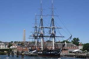
- The Bunker Hill Monument
- Boston Navy Yard, home of the USS Constitution, the USS Constitution Museum, and the USS Cassin Young
- Paul Revere Park
- The Zakim Bridge, the Charlestown Bridge, and the Charles River Dam
Downtown

- TD Garden and North Station
- North End
- Copp's Hill
- Christopher Columbus Park[29]
- Faneuil Hall and Quincy Market
- New England Aquarium
- Historic wharves, including Union Wharf, Lewis Wharf, Long Wharf, Central Wharf, India Wharf, Rowes Wharf, and Russia Wharf
- Custom House Tower and the Custom House District
- Ferry service to Boston Harbor Islands National Recreation Area
- Harbor Towers
- South Station
- Site of the Boston Tea Party
- Northern Avenue Bridge
- Fort Point Channel and Fort Point
South Boston
- Moakley Courthouse on the Fan Pier[30]
- Boston Children's Museum
- Institute of Contemporary Art
- Blue Hills Bank Pavilion
- Castle Island
- Carson Beach
On Columbia Point in Dorchester
- University of Massachusetts Boston
- Edward M. Kennedy Institute for the United States Senate
- John F. Kennedy Presidential Library and Museum
- Massachusetts Archives, home to such artifacts as the Massachusetts Constitution
Farther south
Transportation connections
The Harborwalk is served by many MBTA bus lines.[31] Many public parking lots and garages are nearby.[32] The following subway and commuter rail stops serve the Harborwalk: Maverick Square in East Boston; North Station, Haymarket, Aquarium, and South Station in Downtown Boston; Courthouse, World Trade Center, and Silver Line Way in South Boston; and JFK/UMass and Savin Hill in Dorchester. MBTA Boat services stop at the Navy Yard in Charlestown, at Logan Airport in East Boston, and at Long Wharf and Rowes Wharf downtown.
Future development
New segments continue to be added to the walk as development occurs along the edge of the harbor. A 2012 report prepared for The Boston Harbor Association concluded that approximately 60% of the total possible length of the Harborwalk has been completed.[33]
In March 2016, construction began on a residential building the site of the former Anthony's Pier 4 Restaurant in South Boston. The Harborwalk will extend around the new building.[34]
Another development proposal, on a site adjacent to Pier 4, has been opposed by an environmental group that argues that the proposal's accommodation of the Harborwalk is inadequate.[35]
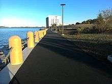
Image gallery (from North to South)
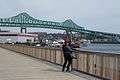 Near the northern end of the Charlestown branch of the Harborwalk, with the Tobin Bridge
 Charlestown near the Boston Navy Yard
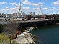 Construction of the Harborwalk, with the Charlestown Bridge and the Zakim Bridge
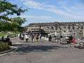 Christopher Columbus Park
.jpg)
.jpg)
 The Harborwalk formerly crossed Fort Point Channel on the Old Northern Avenue Bridge
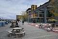
_(10772222526).jpg)
 The JFK Presidential Library and Museum as seen from the Boston Harborwalk on the Columbia Point segment
References
- 1 2 "Boston HarborWalk". The Boston Harbor Association. Retrieved 25 March 2016.
- 1 2 "Article 41A - HarborPark District". Zoning Code. City of Boston. Retrieved 25 March 2016.
- 1 2 3 "Harborwalk". Boston Redevelopment Authority. Retrieved 25 March 2016.
- ↑ "Chapter 91 Public-Access Showcase - Boston HarborWalk". Mass.gov. Retrieved 25 March 2016.
- 1 2 "Chapter 91, The Massachusetts Public Waterfront Act". Mass.gov. Retrieved 25 March 2016.
- ↑ "Harborwalk map". Boston Redevelopment Authority. Retrieved 25 March 2016.
- ↑ "Boston HarborWalk Map" (PDF). Bostons New Waterfront.com. Retrieved 25 March 2016.
- ↑ "Boston Harborwalk". BikeItOrHikeIt.org. Retrieved 25 March 2016.
- ↑ "Boston: Harborwalk". WalkBoston.org. Retrieved 26 March 2016.
- ↑ "Getting to Know Every Inch of the Boston Harborwalk". The Boston Harbor Association. Retrieved 4 May 2016.
- ↑ "Walk to the Sea". Walk to the Sea. Retrieved 2012-05-23.
- ↑ "Quincy RiverWalk". Neponset River Watershed Association. Retrieved 25 March 2016.
- ↑ "Eastport Park Public Art" (PDF). urbancultureinstitute.org. Retrieved 26 March 2016.
- ↑ "University of Massachusetts Boston - Arts on the Point". Retrieved 2013-05-27.
- ↑ "Ross Miller Studio". Rossmiller.com. Retrieved 2016-03-26.
- ↑ "Untitled Landscape". BostonPublicArt.com. Boston Art Commission. Retrieved 12 April 2016.
- ↑ "Charlestown Bells". PaulMatisse.com. Retrieved 17 April 2016.
- ↑ Baker, Billy (8 October 2013). "Artist Paul Matisse, community save Charlestown Bells". Boston Globe. Retrieved 17 April 2016.
- ↑ "Boston Fire Historical Society". Bostonfirehistory.org. Retrieved 2015-05-05.
- ↑ Archived August 20, 2008, at the Wayback Machine.
- ↑ "Massachusetts Korean War Memorial". PublicArtBoston.com. Retrieved 26 March 2016.
- ↑ "Merchant Marine Memorial". Publicartboston.com. Retrieved 2015-05-05.
- ↑ "Maps of the New England Coast at the Boston Harbor Hotel". Norman B. Leventhal Map Center at the Boston Public Library. Retrieved 23 March 2016.
- ↑ "Boston Harbor Hotel". Retrieved 23 March 2016.
- ↑ Iannarone, Kate. "Waterfront Neighborhood Highlight: Charlestown". The Boston Harbor Association. Retrieved 23 March 2016.
- ↑ Kenney, Michael. "Pulling maritime history together". Boston Globe. Retrieved 23 March 2016.
- ↑ "Battery Wharf Hotel". Retrieved 23 March 2016.
- ↑ "Water Transport". Massport. Retrieved 28 April 2016.
- ↑ "Friends of Christopher Columbus Park". Friends of Christopher Columbus Park. Retrieved 1 May 2016.
- ↑ "Fan Pier Boston Master Site Plan". FanPierBoston.com. The Fallon Company. Retrieved 18 April 2016.
- ↑ "Bus Schedules and Maps". MBTA. Retrieved 28 April 2016.
- ↑ "Boston Parking Finder". Best Parking. Retrieved 28 April 2016.
- ↑ Masone, Danielle. "Piecing Together the Boston Harborwalk" (PDF). Worcester Polytechnic Institute. Retrieved 7 September 2016.
- ↑ Logan, Tim (29 March 2016). "Anthony's Pier 4 will fall to wrecking ball". Boston Globe. Retrieved 7 September 2016.
- ↑ Chesto, Jon (10 August 2016). "Environmental group takes on proposed Seaport tower". Boston Globe. Retrieved 7 September 2016.
External links
| Wikimedia Commons has media related to: |
- Boston Redevelopment Authority web page on Harborwalk
- The Boston Harbor Association
- Walk Boston
- Bikeitorhikeit.org trail guide
- Maplets.com trail maps
- Boston Globe guide to the Harborwalk
- New York Times guide to the Harborwalk