East Boston
| East Boston | |
|---|---|
| Neighborhood of Boston | |
|
An airplane approaching Logan International Airport in 1973. | |
| Nickname(s): Eastie, EBO | |
 Neighborhood map of East Boston, Massachusetts | |
| Country | United States |
| State | Massachusetts |
| County | Suffolk |
| Neighborhood of | Boston |
| Annexed by Boston | 1836 |
| Population (2010) | 40,508 |
| Time zone | Eastern (UTC-5) |
| Zip Code | 02128, 02228 |
| Area code(s) | 617 / 857 |
| Website |
www |

East Boston, popularly known as Eastie, is a neighborhood of Boston, Massachusetts with over 40,000 residents. The neighborhood was created by connecting several islands using land fill. It was annexed by Boston in 1836. It is separated from the city proper by Boston Harbor and bordered by Winthrop, Revere, and the Chelsea Creek. Directly west of East Boston, across Boston Harbor, is the North End and Boston's Financial District.
East Boston has long provided a foothold for the latest immigrants with Irish, Russian Jews and then Italians alternating as the predominant group. From the 1990s into the early millennium, Latin American immigrants settled in East Boston. In recent years, East Boston has become home to a wave of young professionals seeking residence in Boston in newly renovated condominiums along Jeffries Point, Maverick Square, and the Eagle Hill waterfront. Jeffries Point specifically has become one of the most desirable neighborhoods, due to its location to the harbor, marinas, and Piers Park. The Kennedy family resided in East Boston. The neighborhood is easily accessible to downtown Boston via the MBTA Blue Line.
In East Boston according to the Boston Redevelopment Authority there are many recreation and housing projects being produced. This will bring opportunities for the residents. The community resources in East Boston are beneficial to the citizens and help with families, children, and elderly in need with money, housing, homelessness, nutrition, etc. The neighborhood has a program which helps individuals and families with affordable housing. Also, a project created by the City of Boston together with Crossroads Family Shelter and the East Boston Community Development Corporation is going to help families transition out of East Boston’s homeless shelter.
On the other hand, rising rents are being an issue for some residents of East Boston which are forcing them to move out of the neighborhood because they cannot afford to pay them. Originally, five islands[1] made up the East Boston neighborhood.
To connect to the mainland, routes, highways, and bridges had to be built. Some popular structures built to bridge that gap between the islands and the mainland include the Tobin Bridge, the Sumner Tunnel and the Callahan Tunnel. Boston's Logan International Airport is located in East Boston connecting Boston to domestic and international locations.[2]
History
Early history
The landmass that is East Boston today was originally made up of five islands — Noddle's, Hog's (later known as Breed's Island, would become Orient Heights), Governor's, Bird, and Apple — that were connected using landfill, the latter three as part of the expansion of Logan Airport during World War II. Not long after the settling of Boston, Noddle Island served as grazing land for cattle.[3]
In 1801, William H. Sumner had proposed to the federal government of the United States to create a turnpike to connect Salem to Boston via the undeveloped Noddle's Island. He argued that the route over it would be more direct making it easier for the neighborhood to develop. He stated
"…in my opinion that the circular route from Chelsea thro’ Charlestown to Boston is about 1 of a mile farther than a direct course over Noddle’s Island in Boston.... The course suggested will be almost in a direct line, from my knowledge of the land….On the back part of the Island is a muddy creek and the distance of the Island to Boston is not so great by one third, I presume as it is from Chelsea to Moreton Point in Charlestown.... There is no doubt that but that the necessities of the town of Boston will some require a connection with Noddle’s Island with the town of which it is part." [4]
The one issue that Sumner foresaw, but glossed over, was that land in Charlestown was purchased by the federal government as the site for a future naval yard. The ships en route from this yard to the ocean would be blocked by the proposed turnpike. He believed that since a standing navy was in such disfavor at that point in the nation’s history that this issue would not stand in his way. However the War of 1812, which was considered a naval war, changed the public's opinion about the needs for a naval yard. Because the route through East Boston and over the Boston Harbor would block ships route to the future Charlestown Navy Yard the turnpike was planned to go through Chelsea as opposed to Noddle's Island.
Formation of East Boston Company
Sumner began to make his move for the acquisition of all of Noddle’s Island upon the death of Colonel David Stoddard Greenough, who had been a longtime holdout against selling to him. Greenough died of apoplexy, and his wife and children wanted to cede their portion of the island. In 1836, Sumner coincidentally married Greenough’s widow, Maria Foster Doane.[5] With the assistance of his new business partners, Steven White and Francis J. Oliver, he purchased the land for $100 per acre or $32,500. This purchase gave Sumner control of one half of the Island. Subsequently in February 1832, the partners formed the East Boston Company. They stated that their part of the Island was to be divided into 666 shares and that it would be managed by a board of directors, who would be able to sell the Company’s interest in the island. Establishing transportation to the area was imperative and they were dedicated to pushing for a railroad connection from Boston to Salem over the Island. They also wanted to establish a ferry system from Boston. Each share of the Company was equivalent to 0.5-acre (2,000 m2). There were 5,280 acres in total, of which, Sumner owned 1320, Mrs. Gerard 880, Steven White 880, and Oliver 440. The rest were spread among twenty-nine other shareholders. By the end of 1833, the East Boston Company had complete control over the entire Island.
Connections to the mainland


In the 1830s, the largest problem keeping East Boston from thriving was transportation. The East Boston Company believed the neighborhood could not become a valuable asset until people had a way to reach the area from the Boston mainland. As a temporary solution, they set up a paddle steamer to carry 15 people at a time from Boston Proper to the neighborhood. It was used primarily for occasional visits from public officials and laborers. Though they did not have the ridership to support additional boats, the company purchased the Tom Thumb steamboat.
The steam railroad system was still in its infancy at this point, and the East Boston Company was approached by an inventor of a new type of rail system, the suspension railway. This system was one of the earliest suspended railroads to be built. The railroad cars were propelled by a steam engine hanging from a suspended track. Henry Sargent, the inventor, stated "that his invention would make the Island a center of attraction to many people." The Company allowed it to be built on its land and it was in use for nine days in 1834, then closed citing lack of ridership.

In the mid-1830s, the Company made several investments to further East Boston's desirability. They continued attempts to get the Eastern Railroad to come to East Boston. The Maverick and East Boston ferries began service from Lewis Wharf on the mainland to East Boston. A bridge to Chelsea was built, roads were laid out, and houses were built. Much of this activity was spurred by the formation of the East Boston Lumber Company. During this period, the Boston Sugar Refinery was also founded, which was the first manufacturing establishment in East Boston. They are credited for the creation of white granulated sugar.[6]
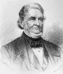
Kennedy family
President Kennedy addressing the people of New Ross, Ireland, June 1963: —
- When my great grandfather left here to become a cooper in East Boston, he carried nothing with him except two things: a strong religious faith and a strong desire for liberty. I am glad to say that all of his great grandchildren have valued that inheritance.
The Kennedy Family lived on Meridian Street in what is now a small home wedged between a Hispanic market and hardware store approaching the Meridian Street branch of the Boston Public Library. The family later moved to a larger home on Monmouth Street. P. J. Kennedy's success enabled him to purchase a home for his son, Joseph, and another for his two daughters at Jeffries Point.
In 1954, John F. Kennedy famously paraded through East Boston with his wife, Jackie, in anticipation for his campaign to run for US Senate, to secure votes from the neighborhood. In a famous photograph, Kennedy is shown walking down Chelsea Street heading towards Maverick Square, waving to the crowd in front of Santarpio's Pizza.[7]
On numerous occasions, Senator Ted Kennedy mentioned that his family's roots are embedded in East Boston throughout his career in the United States Senate.
Later history
Since the mid-19th century, the community has served as a foothold for immigrants to America: Irish and Canadians came first, followed by Russian Jews and Italians, then Southeast Asians, and, most recently, large influx from Central and South American countries. The Orient Heights section of East Boston was the first area in Massachusetts to which Italians immigrated in the 1860s and 1870s, and remains today the heart of the Italian community in East Boston.
The population of East Boston, which was recorded as a mere thousand in 1837, exploded to a high of just over 64,000, according to the 1925 census. The sudden rise is attributed to the immigrants who came from Southern Italy. Today, the neighborhood is home to over 40,000 inhabitants with a median income per household of around $46,000.[8][9]
Transportation


Transportation has long played a role in the shaping of East Boston. The world's finest clipper ships were built at the shipyard owned by Donald McKay in the mid-19th century. A subway tunnel connecting the neighborhood to the rest of the city opened in 1904 and was the first undersea tunnel of its kind in the United States. Rows of houses were torn down to build the Sumner (1934) and Callahan (1961) tunnels, directly connecting automobile traffic from downtown Boston. An airfield was built in the early 1920s, which eventually expanded to become Logan International Airport. The eastern terminus of Interstate 90 (the Massachusetts Turnpike) has been at Route 1A next to Logan Airport since 2003, and the newer Ted Williams Tunnel (1995) links I-90 from East Boston to the rest of the city.
For many years, East Boston’s connections to Boston, which included the Sumner and Callahan tunnels, including the Tobin Bridge by way of Chelsea, were overcrowded. The constant flow of traffic of those who wish to reach the Airport would have to approach one of these passageways, causing traffic jams. The building of the Ted Williams Tunnel has since alleviated much of this traffic problem. The City of Boston has also supplied residents with special transponders, known as Fast Lane (now E-ZPass), that allows them to automatically pay reduced tolls through the Sumner and Ted Williams tunnels.
Logan Airport, New England’s primary international airport and 48th busiest in the world, resides mainly in East Boston (though part of the airfield itself lies in Winthrop). It is almost completely surrounded by water. There has been continual controversy surrounding Logan as constant conflict with the Massachusetts Port Authority has been a source of bitterness among some local residents since its inception. One expansion of the Airport resulted in the loss of Wood Island Park, a green space designed by the noted landscape architect Frederick Law Olmsted. The expansion of Logan Airport in the late 1960s and early 1970s displaced families along Neptune Road, which is now used for warehouses and rental car property. The airport has since implemented four "airport edge buffers," which include parks and greenery to appease residents.[10]
The MBTA's Blue Line stops in East Boston include Maverick, Airport, Wood Island, Orient Heights, and Suffolk Downs. Massport provides free shuttle buses from the Airport MBTA station to all Logan Airport terminals and the Rental Car Center. The East Boston Greenway, a shared use path and park along a former rail line, connects to the Airport station. The Toll Plaza Removal at Sumner Tunnel is a recent issue for commuters and also East Boston residence. It's a process that MassDot is trying to get running by October 2016. In a way, it's making people's lives easier, especially for the ones that commute that won't have to deal with the traffic. At the same time, for the residents of East Boston they are losing many historical roadways. Since the tunnel was created and opened in 1934. Many residents of the area have kept all this streets as historical and the government wants to build it as soon as possible to prevent strikes from anyone who will try to keep all the Historical streets.[11]
The MBTA is another source of transportation for East Boston Residents working outside their area. The cancellation of MBTA late night services has made a big impact on them. For one, they are people who are hardly making any money to survive and by not being able to rely on the MBTA and having to pay a taxi to get home has cost them about two or more hours of work. East Boston's representative Adrian Madaro wrote a letter to the Department of Transportation sharing his findings and asking them to reconsider the idea of cancelling the late services of the MBTA.[12]
Demographics
.jpg)
East Boston's population is ethnically diverse, reflecting the immigrants from around the world who moved into it. Since the early 1900s, immigrants have been a part of the East Boston community. First the Irish and Canadians, then came Russian Jews and Italians, Southeast Asians, and finally Latinos. In 2011, East Boston was estimated to have 41,128 residents living in 14,832 housing units.[13] There are 1,258 empty units in the city. East Boston is a diverse neighborhood. In the neighborhood, the population was spread out into various races. Hispanic/Latino people form the largest race in the city, making up 54.4% of the population followed by whites making up 35.5% of population. The other races such as Asians make up 4.4% of population, black or African American make up 2.9% of the population, two or more races make up 1.9% of population and other makes up 0.9% of population. 50.3% of the population was native, 77.9% were born in Massachusetts, 15.2% were born in other states in the United States, and 6.9% were born outside of the US. East Boston has a very diverse Hispanic community. Unlike other Hispanic communities in the city, which on average are almost exclusively Puerto Rican or Dominican, East Boston's Latino community is mostly composed of immigrants from Central and South America. Immigrants have come from Brazil, Colombia, El Salvador, Guatemala, Honduras and Peru. Helpful sources can be found from the East Boston Immigration Station.[14] Until the immigration of Spanish-speakers, East Boston had an Italian-American majority.
According to the East Boston 2010 Census a definite increase among the Latino population from 2000 to 2010 occurred. Research is shown on specific data of Puerto Rican and Dominican ethnicity in the American Community Survey from 2005-2009 estimate data collected for East Boston.[15] With El Salvador being at the top of the list as 26.6% foreign born population, Dominican Republic foreign born have 3.8% while Puerto Rico did not make the top 20 list of countries. Other countries that made the top 20 list of foreign born that are not Latino include: Morocco, Vietnam, China, Cape Verde, Poland, Haiti, Canada, and Malaysia.[16]
Age/gender
There is a male domination in the city as 53.2% of the population was male and 46.8% of the population was female. The percentage of the male population that worked for the last 12 months was 85.9% and the percentage of female population that worked for the last 12 months was 74.4%.[13] The population in the city is spread out through various ages with 6.9% at age 5 and under, 6.2% from 5 to 9, 4.2% from 10 to 14, 3.5% from 15 to 17, 3.0% from 18 to 19, 8.1% from20 to 24, 10.8% from 25 to 29, 10.7% from 30 to 34, 8.2% from 35 to 39, 7.7% from 40 to 44, 7.2% from 45 to 49, 6.8% from 50 to 54, 4.2% from 55 to 59, 3.1% from 60 to 64, 2.2% from 65 to 69, 2.0% from 70 to 74, 2.0% from 75 to 79, 1.4% from 80 to 84, and 1.8% from 85 and over. There were 14,832 households, of which 33.5% had one or more people under the age of 18 living in them, 4,949 were family households, 2,505 were married-couple family, 842 were male householder, no wife present, 1,602 were female householder, no husband present, and 26 were non-families. 20.1% were households with one or more people 65 years and over.
Income
The median household income in East Boston was $45,849, while the median income for a family was $47,198.[13] Full-time year-round white alone, not Hispanic or Latino workers had a median income of $49,063, black or African American workers had a median of $28,201, Hispanic or Latino workers had a median of $47,384, Asian workers had a median of $32,250, and other race workers had a median of $45,236. In the past 12 months, the per capita income for the city was $22,403. 16.5% of households and 13.8% of families were living in poverty.
Housing
Up until 2011 there were a total of 16,090 housing units in East Boston which 14,832 were occupied and 1,258 were vacant. Out of the 14,832 occupied units, 4,248 were owner-occupied and 10,584 were renter-occupied. The median gross rent was $1,092.[17]
As there is homeless people in the shelters and the streets of East Boston, there has been a project to help them. To help families transition out of East Boston's homeless shelter, the City of Boston together with Crossroads Family Shelter and the East Boston Community Development Corporation joined to create subsidized housing on Havre Street. There will be seven new affordable units as Mayor Martin Walsh cuts the ribbon to start the project.[18]
Gentrification
Rising rents seem to be an issue for some residents in East Boston. Recent renovations to much of the condominium and apartment rental properties in Eastie have resulted in demands for higher rents and some of the residents are being pushed out since they cannot afford to pay the higher monthly rents. People who have been living in East Boston for 5, 10, 15, 20 or more years are slowly but steadily moving further away and out of the city because their landlords keep raising the prices. As one resident named Keylin Chicas stated, she and her family had to move out because their landlord raised the rent from $1,150 one year to $1,700 the following. She is just one of many residents who have been living in East Boston for years, grew up there and have family there, but she, also like many others, had to move to North Revere because she could not find any affordable house in East Boston anymore. The changes in East Boston are happening citywide. Another Hispanic man who is raising his children as a single parent, has seen his landlord raise his rent by close to 50 percent in a year and believes that the rent issues are changing the makeup of the community, stating: "At this rate, in four years there won't be any more Hispanics in East Boston."[19]
Affordable housing
There are programs in East Boston that help low-income residents with affordable housing. NOAH (Neighborhood of Affordable Housing) is a program which serves individuals and families.[20] They serve disadvantaged housing clients, provide free counseling, free education of English language to immigrants, complete no-cost safety-related home repairs for senior and disabled residents, and develop affordable units. NOAH holds bilingual youth leadership, summer schoolyard, and soccer programs for over 180+ at-risk/disadvantaged East Boston children each year.They have also help East Boston with redeveloping school yards, built a waterfront "Urban Wild" park, and a community garden for youth-run. They have also helped with salt marsh restoration; oil spill mitigation; Brownfields "clean up" projects; and air, land and water pollution remediation. The majority of NOAH's clients are either low-income or low/moderate-income and every year, 65% of NOAH's clients are from an ethnic minority household where 50% are Spanish speakers which ties up with the current high population of Hispanic/Latino in East Boston.
Community resources
East Boston's community resources expand into many different organizations and companies whether it be government funded or nonprofit organizations. Just to name a few from City of Boston; Orient Heights Community Center which is now known as The Marcintino Community Center, and Paris Street Community Center.[21]Those two organizations are a part of a major organization all throughout neighborhoods in Boston called Boston Center for Youth and Families.[22] Many of these organizations cater to the youth who live in the neighborhood and are usually available with after school programing. Many community resources also cater to different types of individuals and families such as those who are low-income, non English-speaking, immigrants, victims of abuse, senior citizens, women, in need of housing, and those who are refugees. All of those organizations[23] in East Boston can be found on City of Boston with a full description of their mission. Some more non profit organizations and community neighborhood groups are the following:
Airport Impact Relief, Inc. – Works to reduce and manage airport impacts in East Boston.
Crossroads Family Shelter – Crossroads mission is to support families as they transition from homelessness to independent living and self-sufficiency.
East Boston Community Activity Corp – Holds fundraisers to gather resources that will provide physical education, sports awareness, arts, and other activities for inner city youth.
East Boston APAC – APAC provides advocacy, assistance and care to low income neighborhood residents in a diverse community, helping to solve individual problems while working to promote positive institutional change. It is the largest non-profit human services agency in New England.
East Boston Community Development Corp. (EBCDC) – Low Income and Elderly Housing.
East Boston Main Streets – Their mission is to initiate private and public improvements, promote commerce, and support efforts to improve the quality of life for all who live, work and do business in East Boston.
Let's Get Movin' Programs (including CSA and East Boston Farmer's Market) – Let's Get Movin' offers and manages a variety of programs including after school physical activity programs for youth, parent nutrition education classes, Community Supported Agriculture (CSA) program, the East Boston Farmers Market, a community garden, and school based nutrition classes.
Neighborhood of Affordable Housing (NOAH) – NOAH is an East Boston-based community development corporation structured to collaborate with and support residents and communities in their pursuit of affordable housing strategies, environmental justice, community planning, leadership development, and economic development opportunities.
Neighbors United for a Better East Boston (NUBE) – Neighbors United for a Better East Boston (NUBE) is an organization explicitly of and for low income people, people of color, immigrants and allies that uses issue and electoral organizing to build political power.
Thrive in 5/Countdown to Kindergarten – Play to Learn Playgroups bring together parents, children and an early childhood professional to build a community of peers for support, foster nurturing behaviors, help families access needed services, etc.
YMCA East Boston – The Y brings families closer together, encourages good health and fosters connections through fitness, sports, fun and shared interests.[24]
Healthcare
Rehabilitation and Health Inc. East Boston – Drug & Alcohol Abuse Treatment Services. Long term residential treatment program.
North Suffolk Mental Health Association Meridian House – Drug & Alcohol Abuse Treatment Services. Short and long term residential treatment program.
After Care Services Inc. – Psychological Health & Drug/Alcohol Abuse Services. Outpatient care.
North Suffolk MHA/Noddles Island – Psychological Health & Drug/Alcohol Abuse Services. Day treatment/limited hospitalization and outpatient care.[25]
East Boston Neighborhood Against Substance Abuse – EBNASA is a community based substance abuse prevention coalition currently working with many East Boston agencies, organizations, and residents to employ environmental strategies to increase prevention measures aimed to reducing substance use/abuse and creating a healthier East Boston.[26]
Opioid crisis
Over the past few years the plague of heroin addiction overdoses in East Boston has increased and are continuing to increase. The overdose deaths showed that this neighborhood is not immune to the growing epidemic. Governor Charlie Baker signed landmark legislation into law to address the deadly opioid and heroin epidemic plaguing neighborhoods like Eastie and the state. This law is supposed to strengthen prescribing laws and increase education for students and doctors. It's the first law in the nation to limit an opioid prescription to a 7-day supply for a first time adult prescriptions and a 7-day limit on every opiate prescription for minors, with certain exceptions. Other provisions from the Governor’s recommendations include a requirement that information on opiate-use and misuse be disseminated at annual head injury safety programs for high school athletes, requirements for doctors to check the Prescription Monitoring Program (PMP) database before writing a prescription for a Schedule 2 or Schedule 3 narcotic and continuing education requirements for prescribers—ranging from training on effective pain management to the risks of abuse and addiction associated with opioid medications. While this isn't the end on the opioid crisis, it is a step against the fight against addiction.[27]
Public utilities
Water source
Boston's drinking water comes from two source reservoirs in central and western Massachusetts, the Quabbin and the Wachusetts Reservoirs. This system is known as the Metropolitan Boston Water System. The Massachusetts Water Resources Authority (MWRA) and the Department of Conservation and Recreation (DCR) jointly manage the Metropolitan Boston Water System. Boston Water and Sewer Commission (BWSC) delivers the water to homes and businesses throughout the City of Boston. As one of MWRA's water community members, BWSC represents approximately 33 percent of the current demand on the MWRA water supply. BWSC's water comes from the Quabbin Reservoir and the Wachusett Reservoir, located about 65 miles and 35 miles west of Boston. Water distributed to the Boston metropolitan area is conveyed from the reservoirs through the Cosgrove or Wachusett Aqueducts and treated at the MWRA's John J. Carroll Water Treatment Plant at Walnut Hill in Marlborough. Treatment includes ozone disinfection, pH adjustment with sodium bicarbonate and the addition of chloramines and fluoride.[28]
Urban policies
The Boston Redevelopment Authority for East Boston displays upcoming projects in terms of buildings for housing, and or parks and recreations. This allows residents of East Boston to be aware of what new housing developments taking place and the location. It also informs them of other recreations for instance what the future of Suffolk Downs will be. In a fashion BRA displays the plans in motion or plans being reviewed, plans being approved, leading up to the construction beginning as well as the progress of the development. This gives residents the awareness of the all changes to come in their neighborhood. In terms of policies on zoning, Boston Redevelopment Authority has presented the zoning laws for the cities of Boston in three volumes. To get specific information on East Boston zoning, review the zoning commission on Boston Redevelopment Authority. Again, according to the Boston Redevelopment Authority, it shows that residents are welcome to include input on developments within the community. Boston Redevelopment Authority request residents to access information on urban design, developing projects, planning initiatives, what specific landed is own by the Boston Redevelopment Authority, and Capital construction in East Boston. Residents can access all this information in many different ways, through the site Boston Redevelopment Authority and or attending meetings held at Jeffries Yacht Club in East Boston. East Boston at the time is under many recreations and new housing projects, that are a big opportunity for the residents. "The Boston zoning code dictates the allowed shape, density, and use of development in a given area".[29] A new project that the Boston Redevelopment Authority (BRA) just approved the new project its a "loftel" style hotel which is a $20 million project that will bring benefits not just for the visitors but also the residents. According to the BRA, "A new restaurant serving hotel and the East Boston community will be constructed on the ground floor of the project, and a cafe facing Orleans Street will help to further activate this corner of the neighborhood". "The development team will also add a shuttle bus to reduce the number of vehicles coming to and from the airport or other locations"[30] This project is bringing benefits to East Boston, new jobs may open to the residents as well as reducing traffic.
Sites of interest
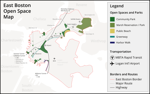
Belle Isle Marsh Reservation
The largest remaining salt marsh in Boston, the 350-acre (1.4 km2) Belle Isle Marsh Reservation, lies in East Boston. The marsh also borders the towns of Revere and Winthrop. It was once a Metropolitan District Commission reservation, but it is now run by the Massachusetts Department of Conservation and Recreation. It is a reserve for a variety of flora and fauna.
Community gardens

East Boston is home to six community gardens, managed by various organizations such as the Boston Parks and Recreation Department and the Boston Natural Areas Network.[31] Participating gardeners at some of the gardens are assigned small plots which they may plant as they like, in exchange for a nominal annual dues payment. Other gardens, such as the "Nuestro Jardin" garden across from the Umana School, was formerly reserved for use by schoolchildren, but is now maintained by a community-based youth program.
Constitution Beach
Located in East Boston is one of Boston's more popular public beaches, Constitution Beach, located in the Orient Heights section of the community. It is known to locals as "Shay's Beach." The beach underwent renovations in the late 1990s as a new public bathhouse and refreshment stand was added, as well as a new pedestrian walkway over the tracks of the Blue Line onto Bennington Street.
Don Orione Shrine
One of the most recognizable landmarks of East Boston is the 35-foot (11 m)-high statue of the Madonna. The Madonna Shrine, atop Orient Heights, is the national headquarters for the Don Orione order. Constructed in 1954, the statue is a full-size replica of the original statue at the Don Orione Center in the Montemario district of Rome, Italy. It was designed by Jewish-Italian sculptor Arrigo Minerbi, who wanted to show his gratitude to the Catholic Church for having shielded him and his family from the Nazis during World War II. Across the street from the Shrine is the Don Orione Home, a nursing home founded by the Don Orione priests.
Historic places
East Boston has eight places on the National Register of Historic Places.
Piers Park
.jpg)
Piers Park is located on the west side of East Boston overlooking Boston Harbor and downtown Boston. Designed by Pressley Associates Landscape Architects of Cambridge, the 6.5-acre park was conceived to reclaim a former pier to allow the neighborhood direct access to its waterfront. The park consists of multiple trails paved in brick and granite from the pier's original 1870 seawalls, native salt-tolerant New England plants, more than thirty-two tree varieties, seasonal flowers, ornamental shrubs, and a 600-foot meandering brick pedestrian promenade with four smaller shade pavilions.[32] One of the pavilions is dedicated to Donald McKay. The park also has an amphitheater and a community boating program, Piers Park Sailing Center.[33]
Santarpio's Pizza

Santarpio's Pizza is a well-known restaurant in the neighborhood. Established in 1903 as a bakery, Frank Santarpio began selling pizza three decades later. A landmark to locals and a destination for visitors, the eatery is primarily known for its New York-style pizza, which it has served at its Chelsea Street location since 1933.[34]
Suffolk Downs
Suffolk Downs, opened in 1935, is a thoroughbred race track located in East Boston. For years, they have held a Grade II race event at the track called the MassCap. Because of declining revenues as result of growing Indian Casinos in Rhode Island and Connecticut, Suffolk Downs canceled the 2009 MassCap.[35] On August 18, 1966, the Beatles played a concert before approximately 24,000 people in the infield of the race track.
Government and business
.jpg)
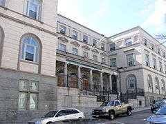
East Boston is the headquarters for District A-7 of the Boston Police Department. The Boston Fire Department has three fire stations in East Boston; Ladder 2 & Engine 9 in Maverick Square, Engine 5 in Day Square, and Ladder 21 & Engine 56 in Orient Heights.
The United States Postal Service operates a branch in East Boston at 50 Meridian Street.[36]
The Logan Office Center, which contains the headquarters of the Massachusetts Port Authority, is adjacent to Logan Airport.[37]
Prior to its dissolution, Air New England was headquartered on the grounds of Logan International Airport.[38]
Education
Public libraries
.jpg)
The first public branch library in the United States was established in East Boston in 1870.[39] Boston Public Library currently has one location in East Boston, at 365 Bremen Street in the Bremen Street Park. This branch opened in November 2013. The East Boston Branch at 276 Meridian Street and the Orient Heights branch at 18 Barnes Avenue were closed in 2013 shortly before the current branch opened.
Primary and secondary schools
Public schools
Boston Public Schools operates numerous schools in East Boston.[40] BPS assigns students based on student preference and priorities of students in various zones. Due to the geography of East Boston, for all grade levels, each resident of the neighborhood is guaranteed a seat at a school in East Boston. The district instructs parents wanting to send their children to East Boston schools to place East Boston campuses on their school assignment priority lists higher than non-neighborhood campus.[41]
East Boston Early Childhood Center is a district K0–1 school in East Boston. District elementary schools include Samuel Adams, Manassah E. Bradley, Curtis Guild, Patrick J. Kennedy, Hugh R. O'Donnell, and James Otis.
Mario Umana Academy and Donald McKay K-8 School are the two district K–8 schools in East Boston. East Boston High School is the sole district public high school in East Boston.
Excel Academy Charter School, a charter middle school, is located on Moore St. in East Boston.[42]
.jpg)
.jpg) Samuel Adams Elementary School
Samuel Adams Elementary School.jpg) Manassah E. Bradley Elementary School
Manassah E. Bradley Elementary School.jpg) Curtis Guild Elementary School
Curtis Guild Elementary School Patrick J. Kennedy Elementary School
.jpg) Donald McKay K-8 School
Donald McKay K-8 School.jpg) Hugh R. O'Donnell Elementary School
Hugh R. O'Donnell Elementary School.jpg) James Otis Elementary School
James Otis Elementary School
Private schools
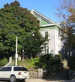
In spring 1892, a school named after Fr. James Fitton was dedicated on the Holy Redeemer site. In 1974, a school merger occurred, producing the current East Boston Central Catholic School.[43] The Roman Catholic Archdiocese of Boston operates East Boston Central Catholic School on the Most Holy Redeemer Parish site. It is a K1–8 school private school in East Boston. The school is managed by a board from the Our Lady of the Assumption, Our Lady of Mount Carmel, Most Holy Redeemer and Sacred Heart parishes.
Savio Preparatory High School was a private, coeducational high school in East Boston before its closing in 2007.[44] In Spring 2008, the Archdiocese ordered the closure of St. Mary, Star of the Sea School, a K–8 school in East Boston. The parish attached to the school closed three years prior to the closure of the school.[45]
Maps
|
|
 |
Notable residents
See also People from East Boston, Boston
- Benjamin A. Botkin, scholar and folklorist
- Thomas J. Buckley, 18th Massachusetts Auditor
- John J. Douglass, member of the United States House of Representatives from 1925–1933
- Frank Greer, rower and Olympic gold medalist
- Helen Johns, swimmer and Olympic gold medalist
- Augie Lio, former American football player and member of the College Football Hall of Fame
- Frederick Mansfield, 46th Mayor of Boston
- James O'Grady, Founder of the Boston Typewriter Orchestra
- William Matthew Prior, noted painter
- Gene Sharp, scholar and three time Nobel Peace Prize nominee
- Robert Travaglini, 93rd President of the Massachusetts Senate
- Jermaine Wiggins, former American football player and Super Bowl XXXVI champion
Current residents
Patrick Bench
See also
- Category:East Boston
- Central Square
- Day Square
- Eagle Hill
- Jeffries Point
- Maverick Square
- Orient Heights
- Italian Americans in Boston
References
- ↑ "Exploring Boston's Neighborhoods: East Boston" (PDF). CityofBoston.gov. Boston Landmarks Commission. 1994. Retrieved 25 November 2015.
- ↑ "East Boston". www.cityofboston.gov. City of Boston. 2013.
- ↑ Sweetser, Moses Foster (1888). King's Handbook of Boston Harbor. p. 124. Retrieved April 8, 2016.
- ↑ Sumner, William H. (1858). A History of East Boston. J. E. Tilton. p. Chapter 14–15. Retrieved March 18, 2013.
- ↑ Memorial Biographies, 1845-1871: 1860-1862, Vol. IV. The New England Historic Genealogical Society. 1885. p. 354.
- ↑ "The Sugar Cane" (14). Galt and Company. 1882: 487. Retrieved 18 March 2013.
- ↑ "East Boston". Chowdaheadz Blog. November 12, 2014. Retrieved March 13, 2016.
- ↑ Rocheleau, Matt (6 April 2011). "Census data: Hispanics/Latinos surpass whites in East Boston". The Boston Globe. Retrieved 13 June 2013.
- ↑ "American Community Survey: East Boston 2007-2011". Boston Redevelopment Authority. Retrieved 29 October 2013.
- ↑ "Airport Edge Buffer Project Planned for Neptune Road". MassPort. March 11, 2009. Retrieved March 18, 2013.
- ↑ Lynds, John. "Toll Plaza Removal: Project Could Lead To Future Depression of Route 1A the Reconnection of Historic Streets?". East Boston Times-Free Press. Retrieved 23 March 2016.
- ↑ Lynds, John. "Representative Madaro Fighting to keep MBTA Late Night service going". East Boston Times- Free Press. Times Staff. Retrieved 5 April 2016.
- 1 2 3 Melnik, Mark; Gao, Lingshan (May 2013). "East Boston Neighborhood". American Community Survey. Boston Redevelopment Authority. Retrieved 25 March 2016.
- ↑ "East Boston Immigration Station". cityofboston.gov. City of Boston. Retrieved July 13, 2010.
- ↑ Boston Redevelopment Authority
- ↑ "East Boston 2010 Census Population". bostonredevelopmentauthority.org. Boston Redevelopment Authority.
- ↑ Melnik, Mark; Gao, Lingshan (May 2013). "East Boston Neighborhood". American Community Survey. Boston Redevelopment Authority. Retrieved April 3, 2016.
- ↑ Lynds, John (November 26, 2015). "City, East Boston CDC Cut Ribbon on Housing for the Homeless". East Boston Times-Free Press. Eastie Times. Retrieved April 1, 2016.
- ↑ RIOS, SIMÓN (July 9, 2015). "'The First To Leave East Boston Are Us': Rising Rents Are Pushing Some Residents Out". 90.0 wbur. WBUR NEWS. Retrieved April 3, 2016.
- ↑ "Programs". NOAH Neighborhood of Affordable Housing Inc.
- ↑ "My Neighborhood - City of Boston". Retrieved 22 November 2016.
- ↑ "Boston Centers for Youth & Families". cityofboston.gov. Retrieved 2014. Check date values in:
|access-date=(help) - ↑ "City of Boston". Retrieved 22 November 2016.
- ↑ "East Boston Organizations, Neighborhood Groups and Elected Leadership" (PDF). www.eastboston.com. East Boston Environmental/Grupo Ambiental Latino. 2014-12-02.
- ↑ "Addiction Rehab Centers in East Boston". Addiction Rehab Centers in East Boston. National Rehab Centers Inc. 2013.
- ↑ "Community Resource Directory - Organization Details". Community Resource Directory - Organization Details. 2015.
- ↑ Lynds, John (March 17, 2016). "Gov Baker Signs Landmark Opioid Bill".
- ↑ "Water Sources". www.bwsc.org. 2016.
- ↑ Interactive, Boston. "What is Zoning ? | Boston Redevelopment Authority". www.bostonredevelopmentauthority.org. Retrieved 2016-04-06.
- ↑ Lynds, John (April 1, 2016). "Loftel Project Approved by the Boston Zoning Board". East Boston Times- Free Press. Times staff. Retrieved April 1, 2016.
- ↑ "Finding a Community Garden". Boston Natural Areas Network. Retrieved March 18, 2013.
- ↑ Guo, Zhan; Jimenez, Alex-Ricardo (2002). "Piers Park, East Boston". Boston.com. Retrieved March 18, 2013.
- ↑ "Piers Park Sailing Center - Boston Harbor". Piers Park Sailing Center. 2010–2013. Retrieved March 18, 2013.
- ↑ Matthew K. Roy (January 27, 2010). "Renowned Pizzeria Eyes Site on Route 1". Salem News.
- ↑ John Lynds (June 24, 2009). "MassCap Canceled as Track Fights to Save Jobs". Revere Journal.
- ↑ "East Boston Post Office". United States Post Office. Retrieved March 18, 2013.
- ↑ "Massport Homepage". MassPort. Retrieved March 18, 2013.
- ↑ "Air Cargo Guide" (21). R.H. Donnelly Corporation. 1977: 11. Retrieved March 18, 2013.
- ↑ "East Boston". 11 July 2016. Retrieved 22 November 2016.
- ↑ "All Schools (A-Z)". Boston Public Schools. Retrieved March 18, 2013.
- ↑ "Student Assignment Policy: East Boston Assignments". Boston Public Schools. Retrieved March 18, 2013.
- ↑ "Excel Academy". Excel Academy. Retrieved March 18, 2013.
- ↑ "East Boston Central Catholic - EBCCS". East Boston Central Catholic. Retrieved March 18, 2013.
- ↑ Stephanie Ebbert (March 2, 2007). "Savio Prep Students and Parents Prep for Closing". Boston Globe.
- ↑ Jeremy C. Fox (January 4, 2011). "Church to Sell St. Mary's Star of the Sea Building". Boston.com.
External links
| Wikimedia Commons has media related to East Boston. |
-
 East Boston travel guide from Wikivoyage
 - EastBoston.com
- City of Boston profile
- East Boston Times-Free Press

Coordinates: 42°22′30″N 71°02′21″W / 42.37500°N 71.03917°W