Dorchester, Boston
| Dorchester | ||
|---|---|---|
| Neighborhood of Boston | ||
|
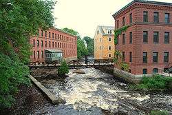
Neponset River at Lower Mills (2009). Dorchester on the left, Milton on the right (south) side of the river. | ||
| ||
| Nickname(s): Dot | ||
|
Motto: Pietate, Literis, Industria (Latin) "Piety, Learning, [and] Industry" | ||
| Country | United States | |
| State | Massachusetts | |
| County | Suffolk | |
| Neighborhood of | Boston | |
| Settled | May 1630 | |
| Incorporated | June 1, 1630 | |
| Annexed by Boston | January 4, 1870[1] | |
| Population (2010)[2] | ||
| • Total | 91,982 or 134,000 | |
| Time zone | Eastern (UTC-5) | |
| • Summer (DST) | Eastern (UTC-4) | |
| Zip Codes | 02121, 02122, 02124, 02125 | |
| Area code(s) | 617 and 857 | |
Dorchester is a historic neighborhood comprising over 6 square miles (16 km2) in Boston, Massachusetts, United States. The town was founded by Puritans who emigrated in 1630 from Dorchester, Dorset, England. This dissolved municipality, Boston's largest neighborhood by far,[3] is often divided by city planners in order to create two planning areas roughly equivalent in size and population to other Boston neighborhoods.
The neighborhood is named after the town of Dorchester in the English county of Dorset, from which Puritans emigrated on the ship Mary and John, among others[4] and is today sometimes nicknamed "Dot" by its residents.[5]
Founded in 1630, just a few months before the founding of the city of Boston, Dorchester now covers a geographic area approximately equivalent to nearby Cambridge.[6] It was still a primarily rural town and had a population of 12,000 when it was annexed to Boston in 1870. Railroad and streetcar lines brought rapid growth, increasing the population to 150,000 by 1920. In the 2010 United States Census, the population was 92,115. Dorchester as a separate municipality would rank among the top five Massachusetts cities.
It has a very diverse population, which includes a large concentration of African Americans and a foreign-born population made up of European Americans, Irish-American immigration, Caribbean Americans, Latinos, and East and Southeast Asian Americans. Most of the people over the age of 25 have completed high school or obtained a GED.[7] Nearly 60% of the population earns less than $40,000[7] per year and a majority of them live in rental units. Currently, there is a foreclosure crisis occurring and, as a result, 25%[8] of the Boston's distressed buildings are located in the community.
History
17th century: Settlement and incorporation
May 30, 1630, Captain Squib of the ship Mary and John entered Boston Harbor and on June 17, 1630, landed a boat with eight men on the Dorchester shore, at what was then a narrow peninsula known as Mattapan or Mattaponnock, and today is known as Columbia Point (more popularly since 1984 as Harbor Point).[9] Those aboard the ship who founded the town included William Phelps, Roger Ludlowe, John Mason, John Maverick, Nicholas Upsall, Capt. Roger Fyler, Henry Wolcott and other men who would become prominent in the founding of a new nation. The original settlement founded in 1630 was at what is now the intersection of Columbia Road and Massachusetts Avenue. (Even though Dorchester was annexed over 100 years ago into the city of Boston, this founding is still celebrated every year on Dorchester Day, which includes festivities and a parade down Dorchester Avenue).
Most of the early Dorchester settlers came from the West Country of England, and some from Dorchester, Dorset, where the Rev. John White was chief proponent of a Puritan settlement in the New World.[10] (Rev. John White has been referred to as the unheralded champion of the Massachusetts Bay Colony, because despite his heroic efforts on its behalf, he remained in England and never emigrated to the Colony he championed.) The town that was founded was centered on the First Parish Church of Dorchester, which still exists as the Unitarian-Universalist church on Meetinghouse Hill and is the oldest religious organization in present-day Boston.
On October 8, 1633, the first Town Meeting in America was held in Dorchester. Today, each October 8 is celebrated as Town Meeting Day in Massachusetts. Dorchester is the birthplace of the first public elementary school in America, the Mather School, established in 1639.[11] The school still stands as the oldest elementary school in America.[12]
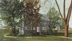
The oldest surviving home in the city of Boston, the James Blake House, is located at Edward Everett Square, which is the historic intersection of Columbia Road, Boston Street, and Massachusetts Avenue, a few blocks from the Dorchester Historical Society. The Blake House was constructed in 1661, as was confirmed by dendrochronology in 2007.[13]
In 1695, a party was dispatched to found the town of Dorchester, South Carolina, which lasted barely a half-century before being abandoned.
18th century
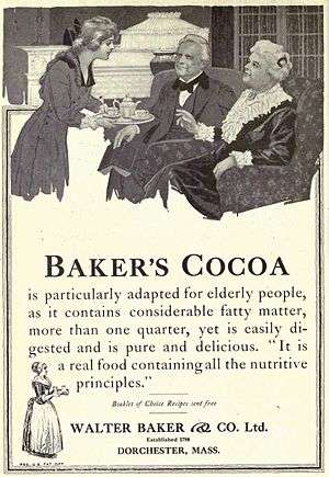
In 1765, chocolate was first introduced in the United States when Irish chocolate maker John Hannon (or alternatively spelled "Hannan" in some sources) imported beans from the West Indies and refined them in Dorchester, working with Dr. James Baker, an American physician and investor. They soon after opened America's first chocolate mill and factory in the Lower Mills section of Dorchester. The Walter Baker Chocolate Factory, part of Walter Baker & Company, operated until 1965.[14]:627[15][16][17]
Before the American Revolution, "The Sons of Liberty met in August 1769 at the Lemuel Robinson Tavern, which stood on the east side of the upper road (Washington St.) near the present Fuller Street. Lemuel Robinson was a representative of the town during the Revolution and was appointed a colonel in the Revolutionary army."[18] Dorchester (in a part of what is now South Boston) was also the site of the Battle of Dorchester Heights in 1776, which eventually resulted in the British evacuating Boston.
19th century
Victorian era
In Victorian times, Dorchester became a popular country retreat for Boston elite, and developed into a bedroom community, easily accessible to the city—a streetcar suburb. The mother and grandparents of John F. Kennedy lived in the Ashmont Hill neighborhood while John F. "Honey Fitz" Fitzgerald was mayor of Boston.
The American poet Oliver Wendell Holmes, wrote a poem called "The Dorchester Giant" in 1830, and referred to the special kind of stone, "Roxbury puddingstone", also quarried in Dorchester, which was used to build churches in the Boston area, most notably the Central Congregational Church (later called the Church of the Covenant) in Boston's Back Bay neighborhood.[19][20]:116
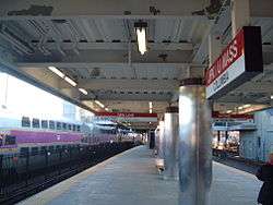
In 1845, the Old Colony Railroad ran through the area and connected Boston and Plymouth, Massachusetts. The station was originally called Crescent Avenue or Crescent Avenue Depot[21] as an Old Colony Railroad station, then called Columbia until December 1, 1982, and then again changed to JFK/UMASS. It is a Massachusetts Bay Transportation Authority rail line station for both the Red subway and the Plymouth/Kingston, Middleborough/Lakeville and Greenbush commuter rail lines.
In the 1840s and 1850s, a new wave of development took place on a strip of waterfront overlooking Dorchester Bay (Park and Mill Streets at the Harrison Square Historic District, later known as Clam Point.) Renowned architects who had contributed to one of the most significant and intact collections of Clam Point's Italianate mansards include Luther Briggs, John A. Fox, and Mary E. Noyes. By the 1890s, Clam Point gained prominence as a summer resort with the Russell House hotel as its centerpiece and the establishment of the Dorchester Yacht Club on Freeport Street.
In the 1880s, the calf pasture on Columbia Point was used as a Boston sewer line and pumping station. This large pumping station still stands and in its time was a model for treating sewage and helping to promote cleaner and healthier urban living conditions. It pumped waste to a remote treatment facility on Moon Island in Boston Harbor, and served as a model for other systems worldwide. This system remained in active use and was the Boston Sewer system's headworks, handling all of the city's sewage, until 1968 when a new treatment facility was built on Deer Island. The pumping station is also architecturally significant as a Richardsonian Romanesque designed by the then Boston city architect, George Clough. It is also the only remaining 19th century building on Columbia Point and is in the National Register of Historic Places.[9]
Annexation to Boston
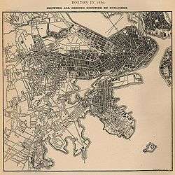
Dorchester was annexed by Boston in pieces beginning on March 6, 1804 and ending with complete annexation to the city of Boston after a plebiscite was held in Boston and Dorchester on June 22, 1869. As a result, Dorchester officially became part of Boston on January 3, 1870.[22] This is also the historic reason that Dorchester Heights is today considered part of South Boston, not modern-day Dorchester, since it was part of the cession of Dorchester to Boston in 1804. Additional parts of Dorchester were ceded to Quincy (in 1792, 1814, 1819, and 1855) and portions of the original town of Dorchester became the separate towns of Hyde Park (1868 and later annexed to Boston in 1912), Milton (1662), and Stoughton (1726, itself later subdivided).
In 1895, Frederick Law Olmsted, architect of the Boston Public Garden/Emerald Necklace and Central Park, was commissioned to create Dorchester Park, to be an urban forest for the residents of a growing Dorchester.[23]
In 1904, the Dorchester Historical Society incorporated "Dorchester Day" which commemorated the settlement of Dorchester in 1630. An annual event, Dorchester Day is a tableau of community events, highlighted by such activities as the Landing Day Observance, the Dorchester Day Parade along Dorchester Avenue the first Sunday in June, and as a grand finale, the Community Banquet.[24]
Turn of the 20th century
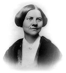
There was also increased social activism in Dorchester during the late 19th and early 20th centuries. Dorchester became home to the first racially integrated neighborhood on Jones Hill. One of the residents of that neighborhood, William Monroe Trotter, with W.E.B. Du Bois, helped to found the Niagara Movement, the precursor of the National Association for the Advancement of Colored People.[25] Many leading suffragettes also lived in Dorchester, including Lucy Stone.[26]
In the early 20th century, Dorchester also saw a large influx of new immigrants from origins such as Ireland, French Canada, Poland, Italy, and migrant African Americans from the south. This is the era when the trademark Dorchester triple decker apartment buildings were built.
1950s–present
In the early 1950s, Dorchester was also a center of civil rights activism. Martin Luther King, Jr. lived there for much of the time he attended Boston University for his PhD. "With Boston’s Baptist community riveted by his preaching and Coretta [Scott King] at his side, King’s circle grew. The Dorchester apartment drew friends and followers like a magnet, according to [friend and roommate John] Bustamante, with 'untold numbers of visitors coming from the other schools.' The roommates housed and fed the visitors, who would join in civil rights discussions."[27]
During the 1950s–1980s, the ethnic landscape of Dorchester changed dramatically. The Jewish and Irish populations were replaced with African, Asian, and Caribbean populations.
The first community health center in the United States was the Columbia Point Health Center in Dorchester. It was opened in December 1965 and served mostly the massive Columbia Point public housing complex adjoining it. It was founded by two medical doctors, Jack Geiger who had been on the faculty of Harvard University then later at Tufts University and Count Gibson from Tufts University.[28][29][30] Geiger had previously studied the first community health centers and the principles of Community Oriented Primary Care with Sidney Kark[31] and colleagues while serving as a medical student in rural Natal, South Africa.[32] The Columbia Point Health Center is still in operation and was rededicated in 1990 as the Geiger-Gibson Community Health Center.[33][34][35]
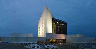
In 1977, after an unsuccessful bid to have the John F. Kennedy Library in Cambridge, Massachusetts close to Harvard University, ground was broken at the tip of Columbia Point for the John F. Kennedy Presidential Library and Museum, designed by the architect I. M. Pei, and dedicated on October 20, 1979.
By the 1980s, the Blue Hill Avenue section of Dorchester had become a predominantly black community. Numerous burned out buildings existed on Blue Hill Ave. During the 1990s, the city administration increased police presence and invested city money into the area for more street lighting.
On March 30, 2015, the Edward M. Kennedy Institute for the United States Senate was dedicated by President Barack Obama.[36] The Institute opened to the public on March 31, 2015.[37]
Geography
Dorchester is located south of downtown Boston and is surrounded by the neighborhoods of South Boston, Roxbury, Jamaica Plain, Hyde Park, South End, and the city of Quincy and town of Milton. The Neponset River separates Dorchester from Quincy and Milton. According to the U.S. Postal Service, Dorchester includes the zip codes 02121, 02122, 02124, and 02125.
Neighborhood sections and squares
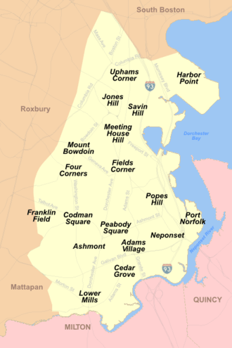
Dorchester is Boston's largest and most populous neighborhood[38] and comprises many smaller sections and squares. Due to its size of about six square miles, it is often divided for statistical purposes in North and South Dorchester. North Dorchester includes the portion north of Quincy Street, East Street and Freeport Street. The main business district in this part of Dorchester is Uphams Corner, at the intersection of Dudley Street and Columbia Road. South Dorchester is bordered to the east by Dorchester Bay and to the south by the Neponset River.[39] The main business districts in this part of Dorchester are Fields Corner, at the intersection of Dorchester Avenue and Adams Street, and Codman Square, at the intersection of Washington Street and Talbot Avenue. Adjacent to Fields Corner is the Harrison Square Historic District, also known as Clam Point, noteworthy for its collection of substantial Italianate Mansard residences.
Dorchester Avenue is the major neighborhood spine, running in a south-north line through all of Dorchester from Lower Mills to downtown Boston.[40] The southern part of Dorchester is primarily a residential area, with established neighborhoods still defined by parishes, and occupied by families for generations. The northern part of Dorchester is more urban, with a greater amount of apartment housing and industrial parks. South Bay Center and Newmarket industrial area are major sources of employment and the Harbor Point area (formerly known as Columbia Point) is home of several large employers, including the Boston campus of the University of Massachusetts, the Massachusetts Archives and Commonwealth Museum, the Edward M. Kennedy Institute for the United States Senate, and the John F. Kennedy Presidential Library and Museum. Distinct commercial districts include Bowdoin/Geneva, Fields Corner, Codman Square, Peabody Square, Adams Village and Lower Mills. Primarily residential areas include Savin Hill, Jones Hill, Four Corners, Franklin Field, Franklin Hill, Ashmont, Meeting House Hill, Neponset, Popes Hill and Port Norfolk.
Demographics
| Historical population | |||
|---|---|---|---|
| Census | Pop. | %± | |
| 1830 | 4,074 | — | |
| 1840 | 4,875 | 19.7% | |
| 1850 | 7,969 | 63.5% | |
| 1860 | 9,769 | 22.6% | |
Up until the 1950s, the Blue Hill Avenue part of Dorchester from Roxbury to Mattapan was primarily composed of Jewish Americans who had lived there for generations.[41] The Neponset neighborhood was primarily Irish-American. During the 1950s–1960s, many African-Americans moved from the South to the North during the Great Migration and settled on Blue Hill Avenue and nearby sections. While some Jewish-Americans were moving "up and out" to the suburbs, certain Boston banks and real estate companies developed a blockbusting plan for the area. The Blue Hill Avenue area was "redlined" so that only the newly arriving African-Americans would receive mortgages for housing in that section.[42] "White flight" was prevalent. Later, Dorchester had another wave of immigrants, this time from Puerto Rico, the Dominican Republic, Haiti, Jamaica, Trinidad and Tobago, Vietnam, Cape Verde, as well as other Latin American, Asian, and African nations. There was still a large number of new immigrants from traditional countries of origin, such as Ireland and Poland. This made Dorchester more diverse than at any point in its long history, and home to more people from more countries than ever before. These immigrants helped revive economically many areas of the neighborhood by opening ethnic stores and restaurants.[43]
The sections of Dorchester have distinct ethnic, racial, and socioeconomic compositions. The eastern areas of Dorchester (especially between Adams Street and Dorchester Bay) are primarily ethnic European and Asian, with a large population of Irish Americans and Vietnamese Americans, while the residents of the western, central and parts of the southern sections of the neighborhood are predominantly African Americans. In Neponset, the southeast corner of the neighborhood, as well as parts of Savin Hill in the north and Cedar Grove in the south, Irish Americans maintain the most visible identity.[44] In the northern section of Dorchester and southwestern section of South Boston is the Polish Triangle, where recent Polish immigrants are residents. Savin Hill, as well as Fields Corner, have large Vietnamese American populations. Uphams Corner contains a Cape Verdean American community, the largest concentration of people of Cape Verdean origin within Boston city limits. Western, central and parts of southern Dorchester have a large Caribbean population (especially people from Haiti, Jamaica, Barbados, and Trinidad and Tobago). They are most heavily represented in the Codman Square, Franklin Field and the Ashmont area, although there are also significant numbers in Four Corners and Fields Corner. Significant numbers of African Americans live in the Harbor Point, Uphams Corner, Fields Corner, Four Corners and Franklin Field areas.[45] In recent years Dorchester has also seen an influx of young residents, gay men and women, and working artists (in areas like Lower Mills, Ashmont Hill/Peabody Square, and Savin Hill).[46][47][48][49][50]
American Community Survey – Estimates – 2013
The American Community Survey (ACS) for Dorchester, from 2007–2011, estimates the total population is 113,975 people. Most of them are female, representing 52.6% or 59,914[7] of the community’s populace and 47.4% or 54,061[7] people are male.
In Dorchester, 68.4% or 77,980 of the citizens are native born and 31.6% or 35,995[7] people are foreign born, 50.1% or 18, 024[7] of them are not U.S. citizens. The largest racial group in the neighborhood is Black or African-American with 49,612 people or 43.05%[7] of the population. People who self-identify as white represent 26,102 or 26.99%[7] of the community. Hispanic/Latino account for 19.09% of the population with 19,295[7] resident. The Asian enclave represents 9.6% of 10,990 [7] of the citizenry. The smallest racial group is bi/multi-racial and they make up 1.9% (2,174[7]) of the population.
According to the ACS survey, Dorchester has a large under 25 population with 38.1% or 43,472[7] people and 33,162 (29.1% of the total population)[7] of them under the age of 19 years old. Between the ages of 25 to 64 years old there are 59,788 or 52.6%[7] people and 10,715 people or 9.3%[7] are over the age of 65 years old. In Dorchester, approximately 61.9% or 70,503 [7] people are over the of 25, 23.5% or 16,582 people[7] do not have a high school diploma or GED , 30.5% or 21,479[7] have a diploma or GED, 18.5% or 13,045 people[7] have completed some college, and 27.5% or19,397 people[7] have a college degree.
The ACS Survey estimates there are 40,443[7] households in the neighborhood of Dorchester, the per capita income of $22,120 and a median income of $44,136. 13.1% or 5,286 [7] households have reported income of less than $10,000. 27.3% or 11,020[7] households earn less than $19,999. 19.1% or 7,720 [7] households earn between $20,000 to 39,999.16.5% or 6,651 [7] households in the earn between $40,000 to 59,999. 19.7% or 7,977[7] households earn between $60,000 to 99,999. 15.3% or 6,174[7] of household report annual incomes of $100,000 to 199,999.[7] Only 2.2% or 901 [7] households in Dorchester earn $200,000 or more per year. The ACS reports as of 2011, Poverty affects 23.5% or 9,511 households and 24.3% 9,820 or [7] households are receiving SNAP Benefits.
Transportation
The neighborhood is served by five stations on the Massachusetts Bay Transportation Authority Red Line (MBTA) rapid transit service, five stations on the Ashmont-Mattapan High Speed Line, five stations on the Fairmount Commuter Rail Line, and various bus routes. Over the last decade, the Dorchester branch of the red line had major renovations, including four rapid transit stations being rebuilt at Savin Hill, Fields Corner, Shawmut, and Ashmont.[51][52] At Ashmont station, the city of Boston and the state of Massachusetts partnered with private investors to create The Carruth, one of the state's first Transit-oriented developments (TOD).[52][53]
Interstate 93 (concurrent with Route 3 and U.S. 1) runs north-south through Dorchester between Quincy, Massachusetts and downtown Boston, providing access to the eastern edge of Dorchester at Columbia Road, Morrissey Boulevard (northbound only), Neponset Circle (southbound only), and Granite Avenue (with additional southbound on-ramps at Freeport Street and from Morrissey Blvd at Neponset). Several other state routes traverse the neighborhood, e.g., Route 203, Gallivan Boulevard and Morton Street, and Route 28, Blue Hill Avenue (so named because it leads out of the city to the Blue Hills Reservation). The Neponset River separates Dorchester from Quincy and Milton. The "Dorchester Turnpike" (now "Dorchester Avenue") stretches from Fort Point Channel (now in South Boston) to Lower Mills, and once boasted a horse-drawn streetcar.
A number of the earliest streets in Dorchester have changed names several times through the centuries, meaning that some names have come and gone. Leavitt Place, for instance, named for one of Dorchester's earliest settlers, eventually became Brook Court and then Brook Avenue Place.[54] Gallivan Boulevard was once Codman Street and Brookvale Street was once Brook Street.[55] Morrissey Boulevard was once Old Colony Parkway.
Economy
Throughout its history, Dorchester has had periods of economic revival and recession. In the 1960s and 1970s, Dorchester was particularly hard hit by economic recession, high unemployment, and white flight.[56]
In 1953, Carney Hospital moved from South Boston to its current location in Dorchester, serving the local communities of Dorchester, Mattapan, Milton and Quincy.
In 1953, a major public housing project was completed on the Columbia Point peninsula of Dorchester. There were 1,502 units in the development on 50 acres (200,000 m2) of land. It was later known for high rates of crime and poor living conditions, and it went through particularly bad times in the 1970s and 80s. By 1988, there were only 350 families living there. In 1984, the City of Boston gave control of it to a private developer, Corcoran-Mullins-Jennison, who redeveloped the property into a residential mixed-income community called Harbor Point Apartments which was opened in 1988 and completed by 1990. It was the first federal housing project to be converted to private, mixed-income housing in the USA. Harbor Point has won much acclaim for this transformation, including awards from the Urban Land Institute, the FIABCI Award for International Excellence, and the Rudy Bruner Award for Urban Excellence.[57][58][59]
During the housing crisis of 2008 in the United States, Dorchester's Hendry Street became the epicenter in the media[60] In reaction, the city of Boston negotiated to buy several of the houses for as little as $30,000. It is moving to seize other foreclosed properties on which the owners have not paid taxes. The houses were renovated and added to the inventory of subsidized rental housing.[61]
In 2008, plans and proposals were unveiled and presented to public community hearings by the Corcoran-Jennison Company to redevelop the 30-acre (120,000 m2) Bayside Exposition Center site on the Columbia Point peninsula into a mixed use village of storefronts and residences, called "Bayside on the Point".[62][63][64][65] However, in 2009, the Bayside Expo Center property was lost in a foreclosure on Corcoran-Jennison to a Florida-based real estate firm, LNR/CMAT, who bought it. Soon after, the University of Massachusetts Boston bought the property from them to build future campus facilities.[66][67]
The corporate headquarters of the Boston Globe is also located in Dorchester. In 2009, the New York Times, current owner, put the paper up for bid, leading to concern from local community members, who had seen other major employers close their doors.[68] After negotiations with their union and cost reduction measures, the New York Times abandoned its plan to sell the Boston Globe in October 2009.[69]
In the 20th century, many of the labor unions in Boston relocated their headquarters to Dorchester. This includes the Boston Teachers Union, International Brotherhood of Electrical Workers Local 103, New England Regional Council of Carpenters, International Association of Fire Fighters Local 718, among others.
Crime
Dorchester, with a population of approximately 130,000, is home to nearly one quarter of all Boston residents. In the early 1990s, Dorchester, along with Roxbury and Mattapan neighborhoods, had the highest percentage of victims with violence-related injuries. Since the early 2000s, crime rates across Boston declined. In the first three months of 2013, Boston crime rates reportedly dropped 15 percent, compared to the same time period in 2012.[70] According to Dorchester Reporter crime maps, the more dangerous areas in Dorchester are located to the west of Columbia Road, with criminal activity centered on Blue Hill Avenue area. Safer parts of the neighborhood include Savin Hill; the historic neighborhood of Clam Point; Columbia Point, which is populated by mostly UMass students; Ashmont Hill; Cedar Grove/Lower Mills area, around the Neponset, Gallivan, and Morrissey Boulevard areas; and the Jones Hill neighborhood (with the third largest percentage of same-sex households in Boston after the South End and Jamaica Plain).[71][72]
Statistics
According to the website Area Vibes,[73][74] the overall crime rate in Dorchester is 30% higher than the national average, and for every 100,000 people there are 10.55 daily crimes that occur in Dorchester such as; violent crimes and property crimes. Property crime is much higher than violent crime. 831 out of 100,000 people are involved in violent crime, and 3,021 out of 100,000 are involved in property crime.
The chance of being a victim of:
- Property crime = 1 in 34
- Violent crime = 1 in 121
- Crime = 1 in 26
Education
Primary and secondary schools
Public schools
Students in Dorchester are served by Boston Public Schools (BPS). BPS assigns students based on preferences of the applicants and priorities of students in various zones.[75]
Dorchester High School predated the annexation of Dorchester to Boston. At its founding, it was an all male school, first opened on December 10, 1852. In 1870 Dorchester was annexed to Boston and its schools became managed by the City of Boston. A replacement facility opened in Codman Square on Talbot Avenue 1901. The current Dorchester facility opened in 1925 on Peacevale Road to males, while the Talbot Avenue building was for females. In 1953 Dorchester High School consolidated as a coeducational school.[76]
Today, Dorchester houses many of the city's high schools. Dorchester Education Complex (formerly Dorchester High School) is in Dorchester.[77] The schools within the Dorchester complex include the Academy of Public Service,[78] the Edward G. Noonan Business Academy,[79] and TechBoston Academy.[80] In September 2009 the Academy of Public Service and the Noonan Business Academy will merge into the Edward G. Noonan Academy for Business, Public Service and Law. Jeremiah E. Burke High School, a high school, is also located in Dorchester.[81]
Other schools include:
- Roger Clap Innovation School K-5
- Boston Collegiate Charter School, grades 5–12
- Codman Academy Charter Public School, 9–12
- Paul A. Dever Elementary School, K-5
- Edward Everett Elementary School, K1-5
- Lilla Frederick Pilot Middle School, 6–8
- Dr. William H. Henderson Inclusion Elementary School (formerly Patrick O'Hearn Elementary School), K-12
- Thomas J. Kenny Elementary School, K-5
- The Mather Elementary School, Pre School-5
- John W. McCormack School, 6–8
- Richard J. Murphy Elementary School, K1-8
- Neighborhood House Charter School, K-8[82]
- William E. Russell Elementary, K1-5
- Smith Leadership Academy Charter School, 5–8
- Lucy Stone School, K-5
- TechBoston Lower Academy (formerly Woodrow Wilson Middle School), 6–9
- Uphams Corner Charter School, 5–8
Parochial schools
Pope John Paul II Catholic Academy of the Roman Catholic Archdiocese of Boston operates the Columbia Campus,[83] the Dorchester Central Campus,[84] the Lower Mills Campus,[85] and the Neponset Campus.[86]
Other parochial schools include:
- Boston College High School, 7–12
- Cristo Rey Boston High School, 9–12, located in old St. William Elementary building (St. Margaret Elementary merged into St. William's building as the first campus of Pope John Paul II Catholic Academy. John Paul II moved buildings and Cristo Rey Boston leases St. William building)
- Elizabeth Seton Academy, 9–12
- St. Ambrose School – closed, K-8
- St. Angela School – (In 2008, closed and reopened as the Mattapan Square Campus of Pope John Paul II Catholic Academy)[87]
- St. Ann Elementary School, K-8 (In 2008, closed and reopened as the Neponset Campus of Pope John Paul II Catholic Academy)[87]
- St. Brendan School, K-6
- St. Gregory Elementary School, K-8 (In 2008, closed and reopened as the Lower Mills Campus of Pope John Paul II Catholic Academy)[87]
- St. Kevin School, K-8 (closed in 2008[88])
- St. Margaret Elementary School, K-8 (Closed and reopened as the Columbia Campus of Pope John Paul II Catholic Academy)[87]
- St. Mark School, K-8(In 2008, closed and reopened as the Dorchester Central Campus of Pope John Paul II Catholic Academy for a short time but has since closed. The building remains in operation and is used for a variety of educational, social, religious purposes.)[87]
- St. Matthew School, K-8
- St. Peter Elementary School, K-8 (closed in 2008[89])
- St. William School
Colleges and universities
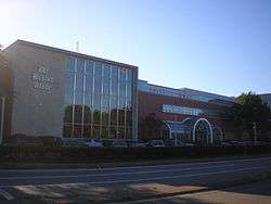
- The University of Massachusetts Boston is an accredited urban public research university and the second largest campus in the University of Massachusetts system. It is located on Columbia Point in Dorchester. The school offers associates, bachelors, masters and doctoral degrees. In regards to race and gender, the school has a diverse student population of about 13 thousand students at a time. Excluding financial aid, the average cost of tuition is 12 thousand in-state and 28 thousand out of state. The cost reflects good value seeing that there is about a 15:1 student faculty ratio with a variety of majors to study. Approximately 20% are Business/marketing, 18% Health Professional, 12% Psychology, 12% Social Sciences, 7% Biology, 7% Security and Protection Services, 6% Parks and Recreation.[90] The economy of the school has been consistently productive since its establishment. Within the past twenty years the school campuses have been improving and expanding. The college has been educating and social developing its residents seeing that 95% of students are instate going full-time.
- Labouré College is a Roman Catholic co-educational college offering associate degrees in nursing and the health sciences. It is located on the Carney Hospital campus near the Lower Mills section of Dorchester.
Public libraries
Boston Public Library operates six neighborhood branches in Dorchester.[91]
- Adams Street Branch
- Codman Square Branch – Originally opened at 6 Norfolk Street in 1905 and was named after a preacher named John Codman. The branch moved into its current facility, which was designed by Eco-Texture, Inc., in 1978.[92]
- Fields Corner Branch
- Grove Hall Branch
- Lower Mills Branch
- Uphams Corner Branch
Health care
Carney Hospital is located on 2100 Dorchester Avenue. Carney Hospital provides over 500 physicians with primary care and specialist physicians. They provided services like behavior health, cancer care, cardiac & vascular, gynecology services, neurology, orthopedics, rehabilitation and physical therapy, along with many more services. Carney Hospital aims to provided the Dorchester community with health and wellness. Carney Hospital has been serving the community since 1863. It is affiliated with Tufts University School Of Medicine, making it a teaching and training hospital for upcoming physicians in both internal medicine and family medicine.[93]
Codman Square Health Center is a community based outpatient healthcare located on 637 Washington Street. They have been a functioning clinic since 1979 with the dream "To build the best urban community in America".[94] They employ about 280 multi-lingual staff members whom most of them reside in the neighborhoods surrounding Codman Square.
In Dorchester there is a local organization by the name of Urban Asthma Coalition. This organization aims to promote the collaboration between other organizations and residents who are concerned about factors in the community that affect asthma. The factors in the community tend to be the environment, quality of health care, access to health care, and education. Residents can join the active committee to promote better health and awareness.[95] The aim is to collaborate with the communities to change the policies through administrative advocacy that affect the community members who have asthma. They have been successful in providing [96] 1,000 new healthy and affordable housing in a year, green and healthy cleaners for the local schools, a city program that works with health professionals and enforcement officers to further the improvement of housing qualities for the children of the area.
Housing
Most of Dorchester's population, about 63.3% or 72,239[7] people, lives in rental housing. The gross median monthly rent is $1,450,[97] which totals $17,40 per year and exceeds the income of almost 30% of the population. An estimated 40,180 people (35.3%)[7] live in owner-occupied homes and 1.4% or 1556 residents live in group homes/shelters.[7]
Excluding government-owned housing, Dorchester has 15,918[98] residential buildings including 4,344 or 27.3% single-family homes, 3,674 or 23.1%[98] two-family homes, 3,919 or 24.6%[98] three-family homes, and 3,981 or 25.0% condo units.[98] The median sales price for all residential property types is 244,450.[97] In 2013, there were 52 foreclosures petitions reported in Dorchester, representing 22.41% of the 232 foreclosures reported for the entire City Boston.[8] Subsequently, 37 out 147 [8] distressed buildings documented in Boston are located in Dorchester.
Safety
Boston Police District C-11 Dorchester, located 40 Gibson St, Dorchester, MA 02122. To create an environment of trust, and empower the neighborhood is the goal. There are over 50 community meetings held monthly that allow the police department to partner with the seniors, community residents, business as well as the faith-based leaders of Dorchester. The police department also works closely to provide the community with crime prevention and safety tips. "Communication is the life-blood of our neighborhood"[99]
Dorchester has available shelters for those in need, a homeless shelter by the name of Pilgrim church (children's services of Roxbury) that is an adult shelter open to men only. This shelter is located on 540 Columbia Road Dorchester MA [100] The shelter is run by the Pilgrim church and it offers over night shelter, food, clothing, showers, first aid, and other supportive services. The shelter also provides evening transportation from Boston to the shelter. The shelter was originally established in 1990 by positive lifestyles and now is currently under the direction of United Homes Adult services.[101]
Public Utilities
- Basic Services
- Public works department
- To get information about trash pick up Sanitation department (617-635-7573)
- Boston recycling (617-635-4959)
- To report pot holes (617-635-4500) [102]
Urban Policies
Income – Massachusetts sales tax rate is 6.25%, income tax is 5.20%. Income per capita is $18,226 which includes adults and children. Median household income $30,419.[103]
Public Policy Issues
There are many controversial public issues that are on the agenda for action by the city hall in Boston. These controversial issues have been in the works for months even years and many of the Dorchester residents are being directly affected along with the quality of their lives. Local residents and activist are working together to find ways to address the issues not only for them and their children but their neighborhoods as well. Some of the problems are public safety, high crime volume, poor educational resources, and lack of housing for low income families. The goals of the organizations are to provided the neighborhood with
- Good Jobs/living wage
- Education for the children
- Housing
- Healthcare resources & Access
- Public Safety & Policy Relations
The Two organizations that are working close knit to tackle these issues; First Parish Dorchester and The Bowdoin Geneva Resident Association.[104]
City Budget Plans
Mayor Marty Walsh proposed a budget for 2017 in which included is a five-year capital plan that is intended to make improvements to the infrastructure of Dorchester. The new projects involve building new libraries and also a modernizing the Boston Public Libraries branches in Dorchester. The City parks are also another investment Walsh intends to take on in the Five year capital plan. The plans are to add more lights to Doherty-Gibson park in Fields Corner and another $3.7 million to make improvements in Harambee park next to the Franklin Field. The rest of the budget is intended to be used to complete already started projects in Savin Hill, King Street, Hemenway, Dower Avenue, and Ronan Park.[105]
Community Resource
Education
Based on the 2010 Census[7] Dorchester has 114,235 for a total population. Just about 15,530 are under the age of eighteen, with this they should all be attending school.[106]
Food
The former president of Trader Joes opened a non-profit retail food shop called the Daily Table,[107]
Entertainment
Dorchester has various attractions, including the JFK Library and Museum,[108] Boston Winery, Strand Theatre, Commonwealth Museum, Greater Boston House Concert. Dorchester has Fields Corner[109] which is a commercial center that is one of Dorchester's largest business district. Fields Corner's stated mission is to continue to be a thriving, welcoming, and secure district with diverse business. There is a plethora of restaurants and clothing stores and various pubs. Fields Corner is known for its Vietnamese restaurants, as well as its large Irish population that brings along a local pub scene. Adjacent to Fields Corner is an 11-acre park known as Hilltop Park, which offers a view of Dorchester Bay and plenty of green space. In the summer months, there is a fresh produce market in the mall parking lot.
Leisure activities and areas
Parks
- Pope John Paul II Park Reservation: The Pope John Park Reservation is approximately 66 acres in size, and is also open year round for the residents of Dorchester. In its earlier times it was used as a landfill and also a drive-in theatre. It also serves as a barricade between the Town of Dorchester, Boston Boston and Neponset River Neponset River waterfront. This park now gives residents various resources such as; Picnic facilities, soccer fields, play areas, paths for walking, and also spacious land to plant trees and shrubs. Unfortunately, it was not always like this. In May 2015 According to James W. Dolan Pope John Paul Park Reservation was not the same as it used to be. The State Department of Conservation and Recreation which is responsible for the park is not really doing its job. The plants are either dead or overgrown. There are no gardens or trees that would catch anyone's eye and also no picnic tables or grills where families could gather around and do a cookout. Dolan states that he wants to see people of the community planting vegetables and tending flower beds in the park, he wants to see people paddling canoes in the river and also a grove of trees so people could sit in the shade and look out at the river.[104]
- Dorchester Park: Dorchester park was established in 1861 and is located in the southern part of Dorchester, specifically in the Cedar Grove and Lower Mills; it is also across from the Neponset River. Dorchester Park is 30 acres and many events are taken place in this historical park, one being the Annual Classic Car Show and Family Fun Day .[105] Dorchester was also listed in the National Registrar of Historic Places .
- Franklin Park: Established in 1885 this parks 485 acres include paved paths which are perfect for taking a nice run, walking and enjoying the scenery, tennis courts, baseball fields, golf courses, and also basketball courts. Also something that is part of Franklin park is New Englands Franklin Park Zoo , where people go to explore the 9 main exhibits that contain more than 220 species of animals. Another activity that is open to the public is Kite and Bike festival which traditionally takes part in Franklin park. This event usually always lands the Saturday after Mothers day. Nearly 100 bikes are provided by Bostons Bike, these bikes range from all sizes for both children and adults. Dotbike volunteers then lead tours around the park so people can get used to riding the bikes. Aside from riding bikes, people are also allowed to fly kites with their families.
Bike Trails
- Lower Neponset River Trail: This 2.4 mile path stretches from the historic port of Norfolk neighborhood in Dorchester, through Pope John Paul II Park, across from Granite Avenue through Neponset Marshes, and through the Lower Mills area to Central Avenue in Milton. This trail is used for running, biking, and also walking. The Neponset River Trial is adjacent to the Butler, Milton village, and Central Avenue Red Line stations which is a way some individuals that may not have their own transportation can get to the trial.
- Neponset River Green way: The Neponset River Green way totals 5 miles in length, it provides scenery to look at while taking a stroll, run, or bike ride such as; a salt marsh in Pope John Paul Park II and Tenan Beach on the mouth of Neponset River . Conveniently the trail is adjacent to three Massachusetts Bay Transportation Authority red line stations such as; Butler, Milton, and Central Avenue.
Sites of interest
- Bayside Expo Center (also known as the Bayside Expo and Conference Center), originally opened as a shopping mall in the 1960s and in 2010 sold to University of Massachusetts Boston for future redevelopment
- The Boston Globe building
- Captain Lemuel Clap House
- Commonwealth Museum[110]
- Dorchester Park
- Edward M. Kennedy Institute for the United States Senate
- First Parish Church of Dorchester
- Franklin Park Zoo
- James Blake House
- John F. Kennedy Presidential Library and Museum
- Neponset River State Reservation[111]
- University of Massachusetts Boston Harbor Campus
- William Clapp House
- William Monroe Trotter House
- Eire Pub, visited by presidents and prime ministers and political candidates
Notable people
- Charles Baker Adams – born in Dorchester. Academic and naturalist.[112]
- William Taylor Adams – wrote fiction under the pseudonym "Oliver Optic" and served on the school board for the Dorchester County Public Schools.[112]
- Sheldon Adelson – born and raised in Dorchester. Chairman and CEO of Las Vegas Sands Corporation and conservative political financier.
- Samuel Turell Armstrong – born in Dorchester. Governor of Massachusetts.[112]
- Robert Bergenheim – raised in Dorchester. Founder of the Boston Business Journal.[113]
- Ray Bolger – vaudevillian and film actor, best known as the Scarecrow in the movie The Wizard of Oz (1939).
- Jean Buckley – born in Dorchester. All-American Girls Professional Baseball League player.
- Whitey Bulger – former crime boss, head of the Winter Hill Gang.
- John Willis (gangster) – imprisoned gangster associated with Chinese organized crime.
- William M. Bulger – Massachusetts politician, former President of the Massachusetts Senate, and former president of the University of Massachusetts.
- Herb Chambers – owner and CEO of Herb Chambers Companies, a group of car dealerships in Massachusetts.
- Buddy Clark, popular crooner (singer) of easy-listening-jazz standards.
- Joe Conforte – owner of the Mustang Ranch in Nevada.
- Clarence Cook – born in Dorchester. 19th century art critic and writer.[114]
- Michael L. Coyne – trial attorney and professor, co-founder and associate dean of the Massachusetts School of Law.
- Norm Crosby – entertainer[115]
- Pete Doherty, known as The Duke of Dorchester – Professional Wrestler
- Thomas M. Finneran – former Speaker of the Massachusetts House of Representatives. In 2007, pleaded guilty to felony obstruction of justice.
- Mike Gorman - longtime TV play-by-play announcer for the Boston Celtics.
- Harry G. Hamlet - Commandant of the U.S. Coast Guard from 1932 to 1936, attended high school in Dorchester
- Kay Hanley – alternative rock musician, vocalist for the band Letters to Cleo.
- Chrystal Herne – Broadway actress.
- Joseph P. Kennedy – businessman, political figure, and father of President John F. Kennedy, Robert F. Kennedy, and Edward M. "Ted" Kennedy.
- Rose Kennedy – mother of John F. Kennedy, Robert F. Kennedy, and Edward M. "Ted" Kennedy.
- John King – broadcast journalist.
- Martin Luther King, Jr. – civil rights leader; lived in Dorchester while attending Boston University.[27]
- Jonathan Knight – singer, part of the musical group New Kids on the Block.
- Jordan Knight – singer, part of the musical group New Kids on the Block.
- Calixa Lavallée – Canadian national anthem composer, also wrote the offertorium for the dedication of St. Peter's of Dorchester (1883).[116][117]
- Dennis Lehane – author of A Drink Before the War (1994), Gone Baby Gone (1998), Mystic River (2001), Shutter Island (2003), and The Given Day (2008).
- Bill Marshall, professional baseball player.
- John Mason - Colonial military officer, civil engineer
- Increase Mather – Puritan minister; public figure in the early history of the Massachusetts Bay Colony.
- Aaron Maund – professional soccer player.
- Albert and David Maysles – documentary filmmakers.
- Marilyn Mosby – Raised in Dorchester. State attorney of Baltimore.[118]
- John Lothrop Motley – historian and diplomat.
- Adam Myerson – professional cyclist.
- Leonard Nimoy – born in Dorchester. Actor, film director, poet, musician, and photographer; best known as Spock on Star Trek.
- Lawrence O'Donnell – Raised in Dorchester. Former aide to Senator Daniel Patrick Moynihan, producer of The West Wing and host of MSNBC's The Last Word with Lawrence O'Donnell.
- Rose Pitonof - marathon swimmer
- Omega Red – rapper, musician and actor.
- Martin Richard – raised in Dorchester; one of three people killed in the Boston Marathon bombing.
- Slaine – hip hop MC, rapper and actor: Gone Baby Gone (2007) and The Town (2010).
- Lucy Stone – abolitionist and suffragist.
- Donna Summer – pop and disco singer, member of Rock and Roll Hall of Fame.
- Donnie Wahlberg – singer, actor and film producer, member of musical group New Kids on the Block, star of TV series Blue Bloods.
- Mark Wahlberg – Academy Award-nominated actor, producer, former model and rapper, star of films including Boogie Nights, The Perfect Storm, Ted, The Departed and The Fighter.
- Michael McMuffin - NHL Insider and Social Media Correspondent
- Danny Wood – singer, best known as part of the musical group New Kids on the Block.
- Marie Wright – better known by stage name "Free", media personality.
Notes and references
Notes
- ↑ "Dorchester MA, Town History 1630–1870", Dorchester Atheneum
- ↑ Bill Forry (2011). "Analysis: City counters bend boundaries, thousands cut out of Dot". Boston Neighborhood News, Inc. Retrieved April 13, 2011.
- ↑ "Boston's Neighborhoods: Dorchester". Boston Redevelopment Authority (BRA). 2010. Retrieved August 17, 2010.
- ↑ Clapp, Ebenezer. History of the Town of Dorchester, Massachusetts. Dorchester, Boston, MA: Dorchester Antiquarian and Historical Society, 1890.
- ↑ "Dot. Dot. Dot.", Boston Globe, September 18, 2005.
- ↑ History of Dorchester, Massachusetts
- 1 2 3 4 5 6 7 8 9 10 11 12 13 14 15 16 17 18 19 20 21 22 23 24 25 26 27 28 29 30 31 32 33 34 Melnik, Mark; Gao, Lingshan. "American Community Survey 2007–2011 Estimate: Dorchester". Boston Redevelopment Authority. Retrieved 4 April 2016.
- 1 2 3 Dillion, Sheila. "Foreclosure Trends 2013" (PDF). City of Boston. City of Boston Department of Neighborhood Development. Retrieved 4 April 2016.
- 1 2 "Calf Pasture Pumping Station"., Dorchester Atheneum
- ↑ "John White, A Founder of Massachusetts, Rev. Arthur Ackerman". Dorchester Atheneum.
- ↑ "Notable Events in Massachusetts".
- ↑ "Mather Elementary School" (PDF).
- ↑ http://www.dorchesteratheneum.org/page.php?id=1513
- ↑ Clapp, Jr., Ebenezer (1859). History of the Town of Dorchester, Massachusetts. Boston: Committee of the Dorchester Antiquarian and Historical Society.
- ↑ Stevens, Peter F. "It Happened in Dorchester: Dr. Baker and the Chocolate Factory". History of Dorchester. Dorchester Reporter.
- ↑ Sweet History: Dorchester and the Chocolate Factory. Dorchester Historical Society and the Milton Historical Society. In conjunction with Kraft Foods
- ↑ Walter Baker & Co. General History. Dorchester Atheneum.
- ↑ "Sons of Liberty in Dorchester", Dorchester Athaneum
- ↑ Holmes, Oliver Wendell, Sr., "The Dorchester Giant", 1830 poem
- ↑ Sammarco, Anthony Mitchell, Boston's South End, Arcadia Publishing, 1995
- ↑ Whiting, E. Map of Dorchester Massachusetts in 1850 (Boston Public Library Map Collection ed.). The maps shows the Crescent Avenue Depot of the Old Colony Railroad Line.
- ↑ "Archived copy" (PDF). Archived from the original (PDF) on 2012-10-16. Retrieved 2014-01-01.
- ↑ "About Dorchester Park", Dorchester Park Association
- ↑ "The Founding of the Dorchester Historical Society", Dorchester Historical Society
- ↑ Taylor, Earl, "Settled before Boston, Dorchester home of many firsts", The Dorchester Reporter, May 29, 2008
- ↑ Stevens, Peter F., "A VOICE FROM ON HIGH: Lucy Stone of Pope's Hill Was a Key Voice in the Early Days of the Women's Movement in America" Archived February 5, 2012, at the Wayback Machine., The Dorchester Reporter, May 26, 2005
- 1 2 Seligson, Susan, "Martin Luther King, Jr.’s Roommate Reminisces: John Bustamante recalls Coretta Scott at Myles Standish, and Dorchester digs", BU Today, January 15, 2010
- ↑ Delta Health Center Records, 1966–1987. University of North Carolina at Chapel Hill: Southern Historical Collection.
- ↑ Shriver, Sargent (June 1, 1967). Remarks of Mr. Shriver at Comprehensive Health Services Press Conference (PDF). p. 5. "Grantee: Tufts University School Of Medicine, Medford, Massachusetts; Operating Institution: Tufts University School of Medicine-Department of Preventive Medicine; Project Director: Count Gibson, M.D., H. Jack Geiger, M.D., Professors of Preventative Medicine, Tufts University; Location: Columbia Point, Boston, Mass. and Bolivar County, Mississippi; Items of Special Interest: One of the original demonstration programs to contrast a model of a northern urban center with a southern rural one; Amount: $1,168,099, $138,888, $281,685, $3,417,630; Date Approved: 6/24/65, 8/65, 3/30/66, 1/15/67"
- ↑ "Count Gibson". George Washington University, School of Public Health and Health Services.
- ↑ Brown, Theodore M.; Fee, Elizabeth (November 2002). "VOICES FROM THE PAST: Sidney Kark and John Cassel: Social Medicine Pioneers and South African Emigrés". American Journal of Public Health. 9 (11): 1744–5. doi:10.2105/AJPH.92.11.1744. PMC 3221478
 . PMID 12406799.
 - ↑ "Jack Geiger". George Washington University, School of Public Health and Health Services.
- ↑ Roessner, Jane (2000). A Decent Place to Live: from Columbia Point to Harbor Point – A Community History. Boston: Northeastern University Press. p. 80. ISBN 1-55553-436-8. The Columbia Point Health Center: The First Community Health Center in the Country.
- ↑ "1965 Columbia Point Health Center" (PDF). Boston History and Innovation Collaborative.
- ↑ Kong, Dolores (October 28, 1990). 25 Years of Intensive Caring. The Boston Globe. p. 29.
- ↑ Evans, Chris (2015-03-30). "President Obama Helps Dedicate the New Edward M. Kennedy Institute". Retrieved 2016-07-01.
- ↑ Khalid, Asma (2015-03-30). "Edward M. Kennedy Institute Opens With A Lofty Goal: Restoring Respect For Congress". Boston. Retrieved 2016-07-01.
- ↑ Mleczko, Monica, "An Unrecognized Gem" Archived February 23, 2012, at the Wayback Machine., The Dorchester Reporter, June 15, 2006
- ↑ Neighborhoods | City of Boston
- ↑ "Archived copy". Archived from the original on 2009-04-14. Retrieved 2010-01-10.
- ↑ Rubin, Jeff (4 November 2014). "Boston's lost Jewish neighborhood reborn on Facebook". Times of Israel. Retrieved 4 November 2014.
- ↑ Levine, Hillel and Lawrence Harmon. "The Death of an American Jewish Community: A Tragedy of Good Intentions. Boston: Free Press, 1991.
- ↑ "Foreign Born in Boston" Archived July 29, 2012, at the Wayback Machine., Boston Redevelopment Authority, October 2007
- ↑ Dorchester Reporter, Dorchester MA USA Archived February 4, 2012, at the Wayback Machine.
- ↑ Dorchester Archived March 2, 2012, at the Wayback Machine.
- ↑ "Dorchester development to be geared toward gays", Bay Windows, Thursday Aug 2, 2007
- ↑ Stidman, Pete, "For Some, Last Calls Heard on the Ave.", Dorchester Reporter, January 31, 2008
- ↑ Diaz, Johnny. "Under a rainbow flag, linking the Dots", Boston Globe, October 30, 2005
- ↑ Kuhr, Fred. 2004. There goes the gayborhood. The Advocate, Jul 6, 2004.
- ↑ "Selling upscale living in Dorchester". The Boston Globe. May 11, 2008.
- ↑ "Ashmont Station Renovation", MBTA
- 1 2 Sullivan, Jim O., "Ashmont Station Project Running into Trouble", The Dorchester Reporter, Feb. 1, 2005
- ↑ Transit-Oriented Development Archived February 4, 2016, at the Wayback Machine.
- ↑ A Record of the Streets, Alleys, Places, Etc. in the City of Boston, Street Laying-Out Dept., Boston, Mass. City of Boston Printing Dept. 1910.
- ↑ "Codman Hill", Dorchester Atheneum
- ↑ Boustan, Leah Platt, "Was Postwar Suburbanization 'White Flight'? Evidence from the Black Migration.", Quarterly Journal of Economics, February 2010.
- ↑ Kamin, Blair. Rethinking Public Housing. Summer 1997. Washington D.C.: Blueprints magazine. p. 4.
- ↑ Roessner, Jane (2000). A Decent Place to Live: From Columbia Point to Harbor Point. Boston: Northeastern University Press. ISBN 1-55553-436-8.
- ↑ Boston War Zone Becomes Public Housing Dream. The New York Times. November 23, 1991.
- ↑ http://www.bostonherald.com/news/opinion/editorials/view.bg?articleid=1072931M
- ↑ Appelbaum, Binyamin (February 15, 2008). "Hendry St. rescue plan underway". The Boston Globe.
- ↑ Stidman, Pete (August 14, 2008). "Sketches outline new-deal for Columbia Point". Dorchester Reporter.
- ↑ Stidman, Pete (July 17, 2008). "Bayside developers go public with site plans". Dorchester Reporter.
- ↑ "Bayside on the Point website".
- ↑ Stidman, Pete (November 13, 2008). Next great neighborhood' planned for Morrissey site. Dorchester Reporter.
- ↑ Forry, Ed, "UMass-Boston seeks to buy Bayside Expo; Motley says no plans for dorms", The Dorchester Reporter, December 16, 2009
- ↑ Anderson, Hil, "Boston’s Bayside Expo Site Sold to University", Trade Show Executive News, January 2010.
- ↑ O'Brien, Keith (June 10, 2009). "Times Co. seeks Globe bids". The Boston Globe.
- ↑ Moore, Galen (October 14, 2009). "New York Times drops plan to sell Globe".
- ↑ http://www.myfoxboston.com/story/21779891/2013/03/24/crime-rates-dropped-15-percent-in-first-three-months-of-2013. Missing or empty
|title=(help) - ↑ "Mapping America — Census Bureau's 2005-9 American Community Survey". The New York Times. December 13, 2010.
- ↑ "Murders in Boston during 2011", boston.com
- ↑ http://www.areavibes.com/boston-ma/north+dorchester/livability/
- ↑ http://www.areavibes.com/boston-ma/south+dorchester/livability/
- ↑ "Student Assignment Policy". Boston Public Schools. Archived from the original on June 13, 2010. Retrieved April 15, 2009.
- ↑ Stevens, Peter F. (June 5, 2003). "Of Debates And Diplomas The Legacy Of Dorchester High School Did Not Arrive Without Struggle". Dorchester Reporter. Retrieved April 15, 2009.
- ↑ "Dorchester Education Complex (formerly Dorchester High School)". Boston Public Schools. Retrieved April 15, 2009.
- ↑ "Academy of Public Service". Boston Public Schools. Retrieved April 15, 2009.
- ↑ "Noonan Business Academy". Boston Public Schools. Retrieved April 15, 2009.
- ↑ "TechBoston Academy". Boston Public Schools. Retrieved April 15, 2009.
- ↑ "Burke High School". Boston Public Schools. Retrieved April 15, 2009.
- ↑ "Home." Neighborhood House Charter School. Retrieved on April 16, 2013. "21 Queen Street, Dorchester, MA 02122"
- ↑ "Columbia Campus." Pope John Paul II Catholic Academy. Retrieved on May 23, 2010.
- ↑ "Dorchester Central Campus Archived March 28, 2010, at the Wayback Machine.." Pope John Paul II Catholic Academy. Retrieved on May 23, 2010.
- ↑ "Lower Mills Campus." Pope John Paul II Catholic Academy. Retrieved on May 23, 2010.
- ↑ "Neponset Campus." Pope John Paul II Catholic Academy. Retrieved on May 23, 2010.
- 1 2 3 4 5 "Pope John Paul II Catholic Academy".
- ↑ Benoit, David (June 19, 2008). "St. Kevin's grads and alums share farewell Mass". The Dorchester Reporter.
- ↑ Stidman, Pete (June 19, 2008). "Class is out at St. Peter's School: Final graduation day marked by tears of joy, sadness". The Dorchester Reporter.
- ↑ "Umass Boston". Statistics.
- ↑ "Neighborhood Branch Libraries" Archived May 6, 2010, at the Wayback Machine., Boston Public Library. Retrieved on May 23, 2010.
- ↑ "Codman Square Branch Library Archived January 5, 2013, at the Wayback Machine.." Boston Public Library. Retrieved on May 23, 2010.
- ↑ "Carney Hospital". Steward Health Care. Retrieved 2016-04-11.
- ↑ "Codman Square Health Center". Retrieved 2016-04-22.
- ↑ "Urban Asthma Coalition". The Dorchester.
- ↑ "Asthma Community Network". Boston Urban Asthma Coalition. Retrieved 2016-04-24.
- 1 2 Friedman, Evelyn. "Real Estate Trends 2011" (PDF). City of Boston. City of Boston Department of Neighborhood Development. Retrieved 4 April 2016.
- 1 2 3 4 "Dorchester Planning District Profile" (PDF). City of Boston. City of Boston Department of Neighborhood Development. Retrieved 4 April 2016.
- ↑ "District C-11 Dorchester". bpd news.
- ↑ "Blog Posts". www.bphc.org. Retrieved 2016-03-04.
- ↑ "My Dorchester". Social Capital inc & DotWell.
- ↑ "Welcome to Boston" (PDF). Martin J Walsh.
- ↑ "Dorchester Massachusetts". Sperling Best Places.
- 1 2 "Dorchester Reporter". Compelling problems + Achievable solutions = positive change. Judy Meredith, Jenn Cartee, Jennifer Johnson, Michael Groves. February 4, 2015. Retrieved April 11, 2016.
- 1 2 Forry, Bill (2016-04-14). "Dorchester Reporter". Retrieved 2016-04-24.
- ↑ "BELL | Mission & History". www.experiencebell.org. Retrieved 2016-04-06.
- ↑ "Daily Table". dailytable.org. Retrieved 2016-04-06.
- ↑ "John F Kennedy". John F Kennedy. Retrieved 27 April 2016.
- ↑ "Fields Corner". Retrieved 27 April 2016.
- ↑ "Commonwealth Museum". CommonwealthMuseum.org.
- ↑ "Neponset River State Reservation". Metro Boston.
- 1 2 3 Who Was Who in America, Historical Volume, 1607–1896. Chicago: Marquis Who's Who. 1963.
- ↑ Stickgold, Emma (2010-06-10). "Robert Bergenheim; founded Boston Business Journal". Boston Globe. Retrieved 2010-06-26.
- ↑ "Clarence Cook Dead". The New York Times. June 3, 1900.
- ↑ Forry, Bill (September 7, 2006). "Crosby comes home for lifetime achievement award". Dorchester Reporter.
- ↑ Lapierre, Eugène, Calixa Lavallée, musicien national du Canada, Montréal, Fides, 1965, p. 235
- ↑ Scanned in at the American Memory Collection of the Library of Congress
- ↑ "Freddie Gray case prosecutor Marilyn Mosby has deep ties to Boston – Metro – The Boston Globe". BostonGlobe.com. Retrieved 14 June 2015.
References
- Committee of the Dorchester Antiquarian and Historical Society, "History of the Town of Dorchester, Massachusetts", Boston : Ebenezer Clapp, Jr., 1859.
- Dutton, E.P. Chart of Boston Harbor and Massachusetts Bay with Map of Adjacent Country. Published 1867. A good map of roads and rail lines around Dorchester. Note the Horse RailRoad on Dorchester Ave.
- Glover, Anna. Glover Memorials and Genealogies: An Account of John Glover Of Dorchester and Some of his Descendants. Published 1867.
- Orcutt, William Dana. Good Old Dorchester: A Narrative History of the Town, 1630–1893. Published 1893.
- Sammarco, Anthony Mitchell.
- Dorchester. Images of America. Dover, N.H.: Arcadia Publishing. 1995. ISBN 0-7524-0228-5. OL 935911M.
- "Dorchester: Volume II", Images of America series, Arcadia Publishing, 2000
- "Dorchester: Then & Now", Arcadia Publishing, 2005.
- Seasholes, Nancy S. (2003). Gaining ground : a history of landmaking in Boston. Cambridge, Massachusetts: MIT Press. ISBN 978-0-262-19494-5.
- The Vital Records of Dorchester (Births, Marriages, and Deaths) to 1825 were published in 1890 as the 21st Report of the Records Commissioners of Boston.
- Old USGS Maps of Boston and Dorchester area. See the 1903 southeaster corner map.
Further reading
- "Railroad Transportation in Dorchester" – History by the Dorchester Atheneum
- Dorchester, Massachusetts, 1790 Federal Head of Household Census, Dorchester, Massachusetts, US Census data
- "Dorchester Epitaphs: from Epitaphs First Burying-Place in Dorchester", (not in Dorchester town records), From the back of the book of Dorchester Vital Records to 1850
- "Historical Sketch of Dorchester", Mercantile Publishing Company, Boston, 1888
- Orcutt, William Dana, Good Old Dorchester: A Narrative history of the Town 1630–1893, Cambridge : John Wilson & Son, University Press, 1893
External links
- from the Boston Public Library Map Collection
- 1831 Map of Dorchester by Edmund J. Baker
- 1850 Map of Dorchester by E. Whiting
- 1868 Map of Dorchester and Quincy by Dudley and Greenough
- 1880 Plan of Dorchester by the Boston Engineering Dept.
- Dorchester Community Website
- Map of Dorchester section of Boston – Open Space Plan, City of Boston
- Boston Redevelopment Authority map of Dorchester
- The La Alianza Hispana records, 1960–1999 (bulk 1975–1995) are located in the Northeastern University Libraries, Archives and Special Collections Department, Boston, MA.
- My Dot Tour, an open-source, "multimedia, youth-led walking tour of Fields Corner." It is "a project of the Fields Corner Collaborative."

Coordinates: 42°19′N 71°3′W / 42.317°N 71.050°W