Bodmin and Wenford Railway
| Bodmin & Wenford Railway | |
|---|---|
 | |
| Locale | Bodmin, Cornwall, England, United Kingdom |
| Terminus | Bodmin General |
| Commercial operations | |
| Name | Bodmin branch line |
| Built by | Great Western Railway |
| Original gauge | 4 ft 8 1⁄2 in (1,435 mm) standard gauge |
| Preserved operations | |
| Operated by | Bodmin and Wenford Railway |
| Stations | 4 |
| Length | 6 1⁄2 miles (10.5 km) |
| Preserved gauge | 4 ft 8 1⁄2 in (1,435 mm) standard gauge |
| Commercial history | |
| Opened | 1887 |
| Closed | 1983 |
| Preservation history | |
| 1990 | Reopened to Bodmin Parkway |
| 1993 | Colesloggett Halt opened |
| 1996 | Reopened to Boscarne Junction |
| Headquarters | Bodmin General |
| Website | |
|
www | |
The Bodmin & Wenford Railway (BWR) is a heritage railway, based at Bodmin in Cornwall, England, United Kingdom. It has an interchange with the national rail network at Bodmin Parkway railway station, the southern terminus of the line.
History
The Great Western Railway opened its branch line from Bodmin Road to Bodmin General 27 May 1887, and on 3 September 1888 a junction line was opened to join with the Bodmin and Wadebridge Railway which had opened its line from Bodmin North to Wadebridge in 1834. The line closed on 3 October 1983 following the demise of freight traffic from Wenford.
In 1984 the Bodmin Railway Preservation Society was formed, and they held their first open day at Bodmin general two years later. 1987 saw the Cornish Steam locomotive Society move their equipment from Bugle to Bodmin.
A Light Railway Order was granted in 1989 and the following year passenger services recommenced between Bodmin General and Bodmin Road, although by now that station had been renamed "Bodmin Parkway". A new intermediate station known as Colesloggett Halt was brought into use. In 1996 the former junction line was also reopened, with another new station provided as Boscarne Junction.
Route
Bodmin & Wenford Railway | |||||||||||||||||||||||||||||||||||||||||||||||||||||||||||||||||||||||||
|---|---|---|---|---|---|---|---|---|---|---|---|---|---|---|---|---|---|---|---|---|---|---|---|---|---|---|---|---|---|---|---|---|---|---|---|---|---|---|---|---|---|---|---|---|---|---|---|---|---|---|---|---|---|---|---|---|---|---|---|---|---|---|---|---|---|---|---|---|---|---|---|---|---|
Legend
| |||||||||||||||||||||||||||||||||||||||||||||||||||||||||||||||||||||||||
The stations served are all in or near Bodmin. They are:
- Bodmin Parkway (50°27′58″N 4°43′00″W / 50.4662°N 4.7168°W)
- Colesloggett Halt (50°26′46″N 4°39′46″W / 50.4461°N 4.6627°W)
- Boscarne Junction (50°28′26″N 4°45′41″W / 50.4740°N 4.7614°W)
- Bodmin General (50°27′36″N 4°40′28″W / 50.4599°N 4.6745°W)
The route from Bodmin General to Bodmin Parkway is 3 1⁄2 miles (5.6 km) and Bodmin General to Boscarne Junction is 3 miles (4.8 km).
On leaving Bodmin parkway, the route first crosses the River Fowey by a five-arch viaduct, and then climbs up towards Bodmin Moor. The one intermediate halt is at Colesloggett Halt, built by the BWR in 1993 to serve a Farm Park (now closed), and provides access to a network of footpaths through the Cardinham Woods, belonging to the Forestry Commission. The trip takes 25 minutes each way.
Upon reaching Bodmin General station, the headquarters of the railway, trains reverse to take the line to Boscarne Junction. This lies on the former London and South Western Railway route to Wadebridge and Padstow, which now forms the Camel Trail alongside the River Camel. The railway has aspirations to extend alongside this foot/cyclepath towards Wadebridge in the future.
Signalling
The railway is controlled by lower quadrant semaphore signals. Access to the Network Rail mainline at Bodmin is controlled by a lever frame, under the supervision of NR's Lostwithiel signal box.
Locomotives
Main line steam locomotives
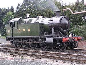
- 4247 – a GWR 4200 Class 2-8-0T heavy freight locomotive built in 1916 that used to haul trains of china clay from St Blazey to Fowey. Its boiler certificate expires in 2021 but is currently (2016) operational in British Railways unlined black livery.
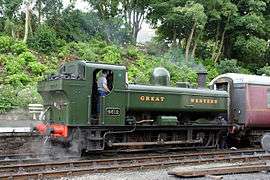
- 4612 – built in 1942. one of the familiar GWR 5700 Class 0-6-0PT pannier tank locomotives that operated out of St Blazey engine shed for use on the china clay branch lines. Its boiler certificate expires in 2023 but is currently (2016) operational in Great Western Railway green livery.
- 5552 – a GWR 4575 Class 2-6-2T familiar from operating passenger trains on most of the Cornish branch lines. built in 1928. It is awaiting overhaul at Bodmin General and painted in British Railways lined green livery.
- 6435 – a GWR 6400 Class 0-6-0PT, another pannier tank, this class was fitted with equipment for working auto trains between Plymouth and Saltash. 6435 emerged from Swindon railway works for the first time in April 1937 and spent many years in Wales. It was condemned on 12 October 1964 and entered preservation with the Dart Valley Railway on 17 October 1965.[1] Its boiler certificate expires in 2022 but is currently (2016) operational and in British Railways lined green livery.
- 30587 – an LSWR 0298 Class "Beattie Well Tank" 2-4-0WT, built in 1874 one of three of these ancient locomotives that were used for many years on the mineral branch from Boscarne Junction to Wenfordbridge. Its boiler certificate expires in 2023.
- 30120 – built in 1899 one of the LSWR Class T9 "Greyhound" 4-4-0s that pulled express trains from Exeter to Wadebridge and Padstow. It is on long-term loan from the National Collection and was overhauled during 2010 to allow it to re-enter service. Its boiler certificate expires in 2020 but is currently (2016) operational in British Railways lined black livery.
Main line diesel locomotives

- D3452 – a British Rail Class 10 0-6-0 diesel-electric (DE) shunting locomotive. After withdrawal by British Rail in July 1968,[2] it was sold to English China Clays plc for further service. It spent much of its subsequent time at Fowey shunting china clay trains. It was bought for preservation in March 1989 and was put to work at Bodmin. It is currently (2016) operational and in British Railways black livery.
- 08444 – a British Rail Class 08 0-6-0DE shunting locomotive. This was the first diesel to arrive on the Bodmin and Wenford Railway, delivered in March 1987 from Cardiff Canton TMD. It was originally number D3559 but later became 08444 which is the number it carries at Bodmin. Operational BR Green[3]
- 33110 – a British Rail Class 33 Type 3 Bo-Bo. This Southern Region locomotive arrived at Bodmin in December 1993.[3] It is currently operational and in British Rail grey livery.
- 37142 – a British Rail Class 37 type 3 Co-Co BR blue. Built in 1963. During preparation on Saturday morning of the 2009 autumn diesel gala, 37142 was found to have contaminated oil. Early examination showed a sudden water leakage from at least two liners. It is currently (2016) operational and in British Railways blue livery.
- 47306 – BR Co–Co Class 47 named "The Sapper". It is currently (2016) operational and in Railfreight Distribution grey livery.
- 50042 – BR Co–Co Class 50 named after the warship "Triumph" br blue. built in 1968, it was taken out of service from Laira TMD at Plymouth in October 1990. Although it had only been overhauled three months earlier, its bogies were exchanged after withdrawal for one with worn out wheels and some parts stolen. It was restored sufficiently to move under its own power by November 1992 and was placed in service the following year.[3] In 2016 it is undergoing overhaul .
Diesel Multiple Units

- BR Class 108 unit
- M50980 British Rail green, operational
- M52054 British Rail green, operational
- M51947 British Rail blue and grey, stored for spares
- These units were built by BR at Derby from 1958 to 1961, and were one of the most numerous types of 1950s DMUs.
Former industrial locomotives

- Alfred – one of the two ex-Port of Par Bagnall 0-4-0STs. Alfred and its older sister engine Judy (see below) were the inspiration for Bill and Ben in the Thomas The Tank Engine stories.Port of Par Green. In 2016 it is awaiting overhaul at Bodmin General.
- Brian - Brian is a 0-4-0 Ruston Hornsby shunter. Named after the late Brian Shadwick, the loco came to Bodmin General in early 2009 for a repaint and routine maintenance. The loco is used as the shed pilot at Bodmin Parkway. Operational in 2016 and carrying HM Devonport Dockyard maroon livery.
- Judy – the older of the two ex-Port of Par Bagnall 0-4-0STs, it was on display at a china clay museum for many years but was moved to Bodmin and entered service at Easter 2009 following a major overhaul. Operational in 2016 and painted in Port of Par green colour.
- 19 – a Bagnall 0-4-0ST. In 2016 it is awaiting overhaul at Bodmin Parkway; painted in HM Devonport Dockyard maroon.
- 2766 – a Hunslet Austerity 0-6-0ST. Undergoing restoration in 2016.
- 3121 – a Bagnall 0-4-0F. Being a fireless locomotive it has a steam reservoir but not a boiler, so it will need an external boiler to charge it should it ever move under its own power. Currently (2016) stored.
Denise-diesel sentinel. In 2016 this is awaiting restoration; painted orange. Peter a Folwer 0-4-0DM Diesel. Undergoing restoration in 2016 at Bodmin General; painted green.
RailTrail Project
RailTrail Planned Extension | ||||||||||||||||||||||||||||||||||||||
|---|---|---|---|---|---|---|---|---|---|---|---|---|---|---|---|---|---|---|---|---|---|---|---|---|---|---|---|---|---|---|---|---|---|---|---|---|---|---|
Legend
| ||||||||||||||||||||||||||||||||||||||
The railway company is currently planning to extend beyond its western terminus at Boscarne Junction towards Wadebridge alongside the Camel Trail. Known as the RailTrail project, phase one would see the railway extended to Nanstallon Halt, phase two to Grogley Halt and phase three to Wadebridge Guineaport.[4]
A separate company (Bodmin & Wadebridge Railway Company) has been set up. It is responsible to the Directors of the Bodmin & Wenford Railway for the promotion and management of all aspects relating to the RailTrail project.
In areas where the width of the trackbed does not allow both a railway and a footpath side-by-side, short diversions are proposed. For example, at Grogley, the Camel Trail could be re-routed along a former "headshunt", which was part of the original railway before it was replaced by a later deviation.
The RailTrail project is viewed by some[4] as somewhat controversial[4] due to the following concerns.
- Sustrans and the cycling/running/walking/equestrian communities have objected to these plans for the RailTrail project, claiming they do not provide significant evidence that a wide-enough multi-purpose trail can be provided. They consider the Camel Trail is currently too narrow at the Boscarne junction terminus due to the railway.
- Some environmentalists have expressed concerns about the impact that the RailTrail project would have on the SSSI and SAC of the Camel valley.[5]
- People living in the Guineaport area of Wadebridge[4] have expressed concerns about having a rail terminus situated there, in the belief that space for a platform and car parking is inadequate.[4]
The decision of North Cornwall District Council to support the project was "a close fought battle", won only by the casting vote of Councillor Graham Facks-Martin.[6][7]
See also
References
- ↑ Woodford, C.G., ed. (1974). Dart Valley Railway Stock Book. Buckfastleigh: Dart Valley Railway. pp. 24–25.
- ↑ "Traction's Preservation Guide". Traction. Steve South (3): 50–53. 1994.
- 1 2 3 Blackwell, Jeremy (1994). "Bank at Bodmin". Traction. Steve South (3): 60–62.
- 1 2 3 4 5 "Full Steam Ahead For RailTrail?". The Cornish Guardian. Retrieved 20 February 2008.
- ↑ "Full Wildlife Lovers' Fears at Train Service Return". The Cornish Guardian. Retrieved 20 February 2008.
- ↑ "Full Railway Gains Council's Support". The Cornish Guardian. Retrieved 20 February 2008.
- ↑ "Camel Rail Plan Wins Support – by a Whisker". The Cornish Guardian. Retrieved 20 February 2008.
External links
| Wikimedia Commons has media related to Bodmin and Wenford Railway. |