Blodgett Mills, New York
| Blodgett Mills, New York | |
|---|---|
| Census-designated place | |
 Blodgett Mills Location within the state of New York | |
| Coordinates: 42°34′5″N 76°7′26″W / 42.56806°N 76.12389°WCoordinates: 42°34′5″N 76°7′26″W / 42.56806°N 76.12389°W | |
| Country | United States |
| State | New York |
| County | Cortland |
| Town | Cortlandville |
| Area | |
| • Total | 2.2 sq mi (5.6 km2) |
| • Land | 2.2 sq mi (5.6 km2) |
| • Water | 0.0 sq mi (0.0 km2) |
| Elevation | 1,085 ft (331 m) |
| Population (2010) | |
| • Total | 303 |
| • Density | 139/sq mi (53.8/km2) |
| Time zone | Eastern (EST) (UTC-5) |
| • Summer (DST) | EDT (UTC-4) |
| ZIP code | 13738 |
| FIPS code | 36-06937 |
Blodgett Mills is a hamlet and census-designated place (CDP) in Cortland County, New York, United States. The population was 303 at the 2010 census.[1] It is in the town of Cortlandville, southeast of the city of Cortland.
Geography
Cortland West is located in the southeast part of Cortlandville and is bordered to the south by the town of Virgil. The Tioughnioga River forms the eastern edge of the CDP and flows south to the Chenango River and ultimately to the Susquehanna River.
U.S. Route 11 passes just east of the community and is accessed by a bridge over the Tioughnioga. US-11 leads northwest 4 miles (6 km) to the center of Cortland and south 10 miles (16 km) to Marathon. Interstate 81 runs just east of US-11 but is not directly accessible from Blodgett Mills.
According to the United States Census Bureau, the Blodgett Mills CDP has a total area of 2.2 square miles (5.6 km2), all land.[1]
References
- 1 2 "Geographic Identifiers: 2010 Demographic Profile Data (G001): Blodgett Mills CDP, New York". U.S. Census Bureau, American Factfinder. Retrieved December 17, 2014.
Municipalities and communities of Cortland County, New York, United States | ||
|---|---|---|
| City | 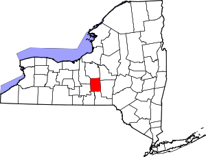 | |
| Towns | ||
| Villages | ||
| CDPs | ||