Bicentennial National Trail
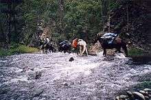
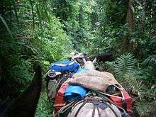
The Bicentennial National Trail (BNT), originally known as the National Horse Trail[1] is one of the longest multi-use, non- motorised, self-reliant trails in the world, stretching 5,330 kilometres from Cooktown, Queensland, through New South Wales and the ACT to Healesville, 60 km north-east of Melbourne. This trail runs the length of the rugged Great Dividing Range through national parks, private property and alongside of wilderness areas. The BNT trail follows old coach roads, stock routes, brumby tracks, rivers and fire trails. It was originally intended for horses, but is these days promoted also for cycling and walking. However it is not yet entirely suited to these two activities.[2]
History
The trail was initiated and planned by the Australian Trail Horse Riders Association. The association spent many years planning and negotiating a route that linked up the mustering, brumby tracks, pack horse trails, historic coach roads and stock routes, thus providing an opportunity to legally ride the routes of stockmen and drovers who once travelled these areas.[3]

The development of this image was left to a committee led by R. M. Williams. Dan Seymour was sponsored by R.M. Williams to find a route along the Great Dividing Range, and to promote enthusiasm for the proposal. Dan volunteered to ride the Trail and set off from Ferntree Gully, Victoria in February 1972 with two saddle horses, a packhorse and ‘Bluey’ his blue heeler cattle dog. The Australian Trail Horse Riders Association provided Dan with encouragement during this lengthy journey. His amazing twenty-one month ride finished in Cooktown, Queensland in September 1973. Dan’s journey, which was regularly reported, created increased interest in the formation of the Trail.
The development of this image was left to a committee led by R. M. Williams and coordinated and planned by Brian Taylor [4] in cooperation with the Australian Trail Horse Riders Association affiliated clubs, farmers, landowners and government agencies.
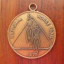
In 1978 the first mail was carried along the route, initially known as the National Horse Trail, from Cooktown by a group of registered riders. These riders were acknowledged with a commemorative medallion.
The Trail committee proposed that the concept be made a project to celebrate Australia’s Bicentenary in 1988. The suggestion was accepted, and funding of $300,000 was available to research, mark a route and print guidebooks. In November 1988, this had been accomplished and the Bicentennial National Trail was opened. Since the opening of the trail people have travelled all or a part of the trail with camels and donkeys as well as with horses and mountain bikes.
Bicentennial National Trail Riders From Cooktown to Healesville 5330 km & From Healesville to Cooktown 5330 km[5]
1989
- Ken Roberts and Sharon Muir Watson (south with Horses Cooktown to Healesville)The first horse riders North to South.
1991
- Arlene Christopherson, (north with horses Healesville to Cooktown) The first horse rider South to North.
- Anthony Mair and Melissa Weeks, (heading north with horses from Healsville to Cooktowwn)
1994
- Gabrielle Schenk (south with horses Cooktown to Healesville)
1995
- Darryl(Doc) Eckley and Robyn Surry Healesville to Cooktown
1997
- Peter Spotswood (Cooktown To Healesville with horses)
1999
- Geoff Daniel (Healesville to Cooktown with horses)
- Ed and Maria Van Zelderen. ( Cooktown to Healsevllle to Cooktown with horses 10000 km) The first Riders both directions.
2000
- Urs Marquardt and Karin Heitzmann, (Cooktown to Healesville on Horses)
- Dyane Sabourin and Geoff Grundy with daughters Angela and Serena Cooktown to Healesville with 12 horses)
2003
- Therese Hanna ( Healesville To Cooktown with horses)
The Trail
This Trail links eighteen of Australia's national parks and more than 50 state forest providing access to some of the wildest, most remote country in the world.[6] The Bicentennial National Trail is suitable for self-reliant horse riders, walkers and mountain bike riders. Parts of the Trail, such as some of the Jenolan Caves to Kosciuszko section, are suitable for horse-drawn vehicles.[6] The BNT trail route is not open to motorised vehicles or trail bikes, and pets or dogs are not permitted. The trail is divided into 12 sections, of 400 to 500 kilometres, each with a corresponding guide book.
1. Cooktown to Gunnawarra; the trail passes through rain forest, gold fields and historical tin mining towns.
2. Gunnawarra to Collinsville, through the grazing country of far north Queensland.
3. Collinsville to Kabra
4. Kabra to Biggenden
5. Biggenden to Blackbutt
6. Blackbutt, Queensland to the New South Wales border at Cullendore; this start of this section of the trail follows the Brisbane Valley Rail Trail.[7]
7. Killarney to Ebor; this is a rugged remote section that follows the Guy Fawkes River through Guy Fawkes River National Park[8] and across Waterfall Way.
8. Ebor to Barrington Tops, is another rugged remote section that passes through Oxley Wild Rivers National Park. After passing Ebor the trail crosses the Point Lookout Road before it passes briefly through Cunnawarra National Park. It then runs on the east of Georges River until it crosses the Armidale to Kempsey road. The track is mostly unmarked as it follows the Macleay River past the historic East Kunderang homestead in Oxley Wild Rivers National Park. Following Kunderang Brook it winds its way to mustering huts at Left Hand Hut, the remote Middle Yards Hut, Youdale’s Hut and to Cedar Creek on the edge of Werrikimbe National Park. After crossing the Oxley Highway the trail passes through the Mummel Gulf National Park. This section takes at least five days to travel and all food and equipment has to be carried. There are numerous creek and river crossings, with some steep ascents and descents.
9. Barrington Tops to Jenolan Caves
10. Jenolan Caves to Kosciuszko

11. Mt Kosciuszko to Omeo, including the Tom Groggin Track
12. Omeo to Healesville, near Melbourne
National Mail Relay Ride
Alan Rideout handing the National Mail Relay Ride saddlebags to Brian Taylor at Callide, having just completed a 108 kilometres for the day from Mt Morgan (1978). Allan Rideout features in the story 'One Of A Few'.
Route
See also
References
- ↑ Bicentennial National Trail Retrieved 2009-10-10
- ↑ Bushwalking - Bicentennial National Trail
- ↑ "Bushwalking the Bicentennial National Trail". Retrieved 2008-04-10.
- ↑ Bicentennial National Trail | A Swag of Memories
- ↑ http://www.bicentennialnationaltrail.com.au/about/recognition/
- 1 2 The Bicentennial National Trail, Welcome to One of the World's Great Natural Adventures
- ↑ "Section Six – Blackbutt to the Border". The Bicentennial National Trail. The Bicentennial National Trail Ltd. Retrieved 29 May 2014.
- ↑ NSW Wilderness Red Index - Guy Fawkes Retrieved on 12 December 2012
External links
- Bicentennial National Trail Guidebooks
- The Long Riders Guild
- Trans Canade Trail
- John Chapman on The Bicentennial National Trail
- Mountain Bikes on the BNT