Benton County Poor Farm Cemetery
|
Benton County Poor Farm Cemetery | |
 | |
  | |
| Location | W. side NE. Young Ave. approx. 200 ft. N. of NE. Carnahan Ct., Bentonville, Arkansas |
|---|---|
| Coordinates | 36°23′34″N 94°12′2″W / 36.39278°N 94.20056°WCoordinates: 36°23′34″N 94°12′2″W / 36.39278°N 94.20056°W |
| Area | less than one acre |
| Built | 1860 |
| NRHP Reference # | 08000431[1] |
| Added to NRHP | May 20, 2008 |
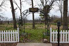
The Benton County Poor Farm Cemetery is a historic cemetery in Bentonville, Arkansas. It is located off NE Young Avenue in a residential subdivision northeast of the city's center. It was established c. 1860, around the time Benton County's poor farm was established, and it was in active use until the poor farm was closed c. 1930. It has a small number of marked graves, and an unknown number of unmarked graves, some of which are distinguishable by the presence of depressions in the ground.[2]
The cemetery, which is the only tangible remnant of the poor farm, was listed on the National Register of Historic Places in 2008.[1]
See also
References
- 1 2 National Park Service (2010-07-09). "National Register Information System". National Register of Historic Places. National Park Service.
- ↑ "NRHP nomination for Benton County Poor Farm Cemetery" (PDF). Arkansas Preservation. Retrieved 2015-01-24.
| Topics | |
|---|---|
| Lists by states |
|
| Lists by insular areas | |
| Lists by associated states | |
| Other areas | |
| |
This article is issued from Wikipedia - version of the 11/30/2016. The text is available under the Creative Commons Attribution/Share Alike but additional terms may apply for the media files.