Barnstaple Long Bridge
| Barnstaple Long Bridge | |
|---|---|
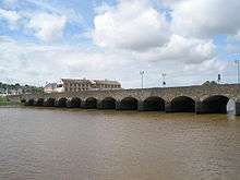 Barnstaple Long Bridge, seen from the Barnstaple side of the river | |
| Coordinates | 51°04′39″N 4°03′36″W / 51.0775°N 4.0600°WCoordinates: 51°04′39″N 4°03′36″W / 51.0775°N 4.0600°W |
| OS grid reference | |
| Carries | A3125 road |
| Crosses | River Taw |
| Locale | Barnstaple, Devon, England |
| Heritage status | Grade I listed building, ancient monument |
| Characteristics | |
| Material | stone |
| Total length | 159 metres (522 ft) |
| Number of spans | 16 |
Barnstaple Long Bridge is a medieval bridge linking Tawstock with Barnstaple in North Devon, England, spanning the River Taw. One of the largest medieval bridges in Britain, it is a Grade I listed building and ancient monument.[1][2] Another major medieval bridge, the Bideford Long Bridge over the Torridge, is a few miles away.[3][4]
History
The date of the first bridge as Barnstaple's main bridge across the River Taw is unclear.[5][6] A will of 1274 left money for its upkeep and it underwent construction work around 1280 with further work being undertaken in 1333, and the bridge was partially destroyed in 1437 and 1646.[7][6] It is unclear whether all of the arches were originally built of stone or whether three were wooden (known as "maiden Arches") until replacement in the 16th century.[8]
In 1796, the bridge was widened again.[1] The footpath was added in the 1830s and cast iron used to strengthen the bridge under the direction of James Green.[6][1] In the 1960s some of the original stonework of the deck was replaced with concrete faced with masonry, above the original stone arches,[6] removing the Victorian ironworks to give the bridge an image identical to how it would have looked between 1796 and 1832.
Traffic congestion was considerable on the bridge until, in May 2007, the Barnstaple Western Bypass was opened so traffic heading towards Braunton and Ilfracombe avoids travelling through the town centre over the ancient bridge. The bypass consists of 1.6 miles (2.6 km) of new road and a 447 yards (409 m) long, five-span bridge. It was expected to have cost £42 million.[9] In 2016 plans were announced to upgrade the bridge including widening of footpaths and the creation of cycle lanes.[10]
Structure
Long Bridge has 16 pointed masonry arches, varying in span from 5.5 metres (18 ft) to 7.9 metres (26 ft) giving a total length of 159 metres (522 ft).[1]
References
| Wikimedia Commons has media related to Long Bridge, Barnstaple. |
- 1 2 3 4 "Name: LONG BRIDGE List entry Number: 1384979". Historic England. Archived from the original on 6 September 2015. Retrieved 11 June 2015.
- ↑ Harrison, David. "Bridges: Past & Future. The current state of knowledge and proposals for future research.". archaeologydataservice.ac.uk. Medieval Settlement Research. Retrieved 12 October 2015.
- ↑ R. A. Otter (1994). Southern England. Thomas Telford. pp. 57–8. ISBN 978-0-7277-1971-3.
- ↑ Nigel Yates; James Melvin Gibson (1994). Traffic and Politics: The Construction and Management of Rochester Bridge, AD 43-1993. Boydell & Brewer. p. 48. ISBN 978-0-85115-356-8.
- ↑ Holton, Denise; Hammett, Elizabeth (2015). Secret Barnstaple. Amberley. ISBN 9781445642970.
- 1 2 3 4 "Barnstaple Long Bridge". Gatehouse. Retrieved 13 August 2016.
- ↑ "Barnstaple Long Bridge". Engineering Timelines. Archived from the original on 2014-04-07. Retrieved 2014-04-05.
- ↑ Cruse, John B. "The Long Bridge of Barnstaple & The Long Bridge Trust" (PDF). The Bridge Trust. Retrieved 13 August 2016.
- ↑ "Barnstaple Western Bypass". Devon County Council. Retrieved 3 July 2016.
- ↑ Peter, N.D.J. (29 July 2016). "Barnstaple Long Bridge upgrades could replace plans for new River Taw footbridge". North Devon Journal. Retrieved 13 August 2016.
Further reading
- Oliver, Bruce W., The Long Bridge of Barnstaple, Transactions of the Devon Association, vol. 70 (1938) pp.193-197; vol. 78, (1946) pp.177-191.