Barabanki, Uttar Pradesh
| Barabanki बाराबन्की بارہ بنکی | |
|---|---|
| city | |
|
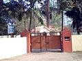
The Uttar Pradesh State Road Transport Corporation (UPSRTC) Bus Station at Barabanki | |
 Barabanki  Barabanki Location in Uttar Pradesh, India | |
| Coordinates: 26°55′N 81°12′E / 26.92°N 81.2°ECoordinates: 26°55′N 81°12′E / 26.92°N 81.2°E | |
| Country |
|
| State | Uttar Pradesh |
| District | Barabanki |
| Government | |
| • Chairman | Ranjeet Bahadur Srivastava |
| Area | |
| • Total | 2,202 km2 (850 sq mi) |
| Elevation | 125 m (410 ft) |
| Population (2011) | |
| • Total | 146,831 |
| • Density | 331/km2 (860/sq mi) |
| Languages | |
| • Official | Hindi, Urdu |
| Time zone | IST (UTC+5:30) |
| PIN | 225 001 |
| Telephone code | 5248 |
| Vehicle registration | UP-41 |
| District Magistrate | Sri Yogeshwar Ram Mishra, IAS |
| Website |
barabanki |

Barabanki is a city in the state of Uttar Pradesh in India. It is the administrative headquarters of Barabanki District. The city is about 29 km east of Lucknow, the state capital.
City configuration
Barabanki city comprises:
- Barabanki village (revenue village)
- Nawabganj (tehsil)
- Banki (town area)
- Barel (village)
- Satrikh (village)
- Kurauli (village)
- 252 Bomb Disposal Company (cantonment)[1]
- Suburbs
Demographics
As per provisional data of the 2011 census, the Barabanki urban agglomeration had a population of 146,831, with 77,766 males and 69,065 females. The literacy rate was 81.85%.[2]
Barabanki District is classified by the national government as a "Minority Concentrated District in India"[3] and Barabanki city is classified as a Muslim-majority city in the government files.[4]
Famous residents
- K D "Babu" Singh, hockey player
- Naseeruddin Shah, film actor
- Khumar Barabankvi, poet
- Rafi Ahmed Kidwai, politician.
- C.M. Naim, scholar of Urdu language and literature.
- Adya Prasad Chaturvedi, Hindi writer & Doctor
- Zubaida Rashid Educationist
Climate
| Climate data for Nawabganj, Barabanki | |||||||||||||
|---|---|---|---|---|---|---|---|---|---|---|---|---|---|
| Month | Jan | Feb | Mar | Apr | May | Jun | Jul | Aug | Sep | Oct | Nov | Dec | Year |
| Average high °C (°F) | 22.0 (71.6) |
26.0 (78.8) |
32.0 (89.6) |
38.0 (100.4) |
40.0 (104) |
39.0 (102.2) |
34.0 (93.2) |
33.0 (91.4) |
33.0 (91.4) |
33.0 (91.4) |
29.0 (84.2) |
24.0 (75.2) |
31.9 (89.4) |
| Daily mean °C (°F) | 15.0 (59) |
18.5 (65.3) |
23.5 (74.3) |
29.5 (85.1) |
32.5 (90.5) |
33.0 (91.4) |
30.0 (86) |
29.5 (85.1) |
28.5 (83.3) |
26.5 (79.7) |
21.0 (69.8) |
16.5 (61.7) |
25.3 (77.5) |
| Average low °C (°F) | 8.0 (46.4) |
11.0 (51.8) |
15.0 (59) |
21.0 (69.8) |
25.0 (77) |
27.0 (80.6) |
26.0 (78.8) |
26.0 (78.8) |
24.0 (75.2) |
20.0 (68) |
13.0 (55.4) |
9.0 (48.2) |
18.8 (65.8) |
| Average rainfall mm (inches) | 18.5 (0.728) |
12.6 (0.496) |
8.3 (0.327) |
4.9 (0.193) |
39.4 (1.551) |
80.3 (3.161) |
212.1 (8.35) |
187.3 (7.374) |
170.1 (6.697) |
32.3 (1.272) |
7.0 (0.276) |
13.7 (0.539) |
786.5 (30.965) |
| Average rainy days (≥ 0.1 mm) | 2.0 | 2.0 | 2.0 | 1.0 | 3.0 | 7.0 | 15.0 | 14.0 | 9.0 | 2.0 | 1.0 | 1.0 | 59 |
Gallery
-
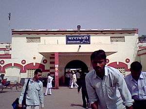
Outside view of Barabanki Jn Railway Station
-
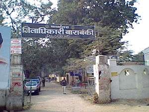
Office of District Magistrate/Collector
-

Barabanki Head Post Office
-

Barabanki Kotwaali
-
Office of Tehsildar of Tehsil Nawabganj, Barabanki on Lucknow-Faizabad Road (NH-28)
-

Nagar Parishad Nawabganj
-

Barabanki Clock Arch
-
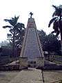
Shahid Smarak (a World War II memorial)
-
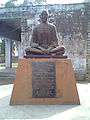
Statue of Mahatma Gandhi at Baapu Bhawan at Dewa Road
-
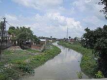
Jamuriya Nala (a brook) from Railway Station Road Bridge. This brook flows through the city and divides it into two halves.
-
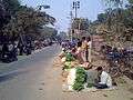
Evening vegetable bazaar along Court Road
-
_procession_Barabanki_India_(Jan_2009).jpg)
Shia Muslims on a Ta'ziya procession on the Day of Ashura
-
_procession_Barabanki_India_(Jan_2009).jpg)
Shia Muslims on an Alam procession on the Day of Ashura
References
| Wikisource has the text of the 1911 Encyclopædia Britannica article Bara Banki. |
- ↑ "252 Bomb disposal Company (Barabanki)". Wikimapia.org. Retrieved 2012-06-17.
- ↑ "Urban Agglomerations/Cities having population 1 lakh and above" (PDF). Provisional Population Totals, Census of India 2011. Retrieved 2012-07-07.
- ↑ "Identification of Minority Concentration Districts". Press Information Bureau (Government of India). 2007-06-22. Archived from the original on 28 October 2009. Retrieved 2009-10-31.
- ↑ Ashok, Akash Deep (6 December 2013). "Babri Masjid anniversary: A few more things that were demolished that day". India Today. New Delhi. Retrieved 7 December 2013.