Banks Springs, Louisiana
| Banks Springs, Louisiana | |
|---|---|
| Census-designated place | |
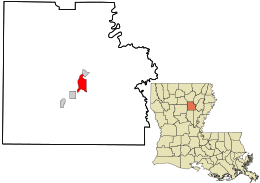 Location in Caldwell Parish and the state of Louisiana. | |
| Coordinates: 32°4′55″N 92°5′34″W / 32.08194°N 92.09278°WCoordinates: 32°4′55″N 92°5′34″W / 32.08194°N 92.09278°W | |
| Country |
|
| State |
|
| Parish | Caldwell |
| Area | |
| • Total | 8.1 km2 (3.1 sq mi) |
| • Land | 8.1 km2 (3.1 sq mi) |
| • Water | 0 km2 (0 sq mi) |
| Elevation | 60 m (200 ft) |
| Population (2010) | 1,192 |
| • Density | 146.8/km2 (380/sq mi) |
| Time zone | CST (UTC-6) |
| • Summer (DST) | CST (UTC-5) |
| ZIP Codes | 71418 |
| Area Code | 318 |
Banks Springs is an unincorporated community and census-designated place (CDP) in Caldwell Parish, Louisiana, United States. As of the 2010 census it had a population of 1,192.[1] It is located near the center of Caldwell Parish 2 miles (3 km) south of Columbia, the parish seat, and 2.5 miles (4.0 km) north of Grayson. The CDP includes the neighborhood of Columbia Heights.
U.S. Route 165 passes through the center of Banks Springs, leading north 34 miles (55 km) to Monroe and southwest 62 miles (100 km) to Alexandria.
References
- ↑ "Geographic Identifiers: 2010 Demographic Profile Data (G001): Banks Springs CDP, Louisiana". U.S. Census Bureau, American Factfinder. Retrieved August 18, 2014.
Municipalities and communities of Caldwell Parish, Louisiana, United States | ||
|---|---|---|
| Town | 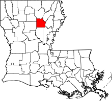 | |
| Villages | ||
| CDP | ||
| Other unincorporated communities | ||
This article is issued from Wikipedia - version of the 8/3/2015. The text is available under the Creative Commons Attribution/Share Alike but additional terms may apply for the media files.