Banbasa
| Banbasa | |
|---|---|
| town | |
 Banbasa  Banbasa Location in Uttarakhand, India | |
| Coordinates: 28°58′48″N 80°04′48″E / 28.979913°N 80.080032°ECoordinates: 28°58′48″N 80°04′48″E / 28.979913°N 80.080032°E | |
| Country |
|
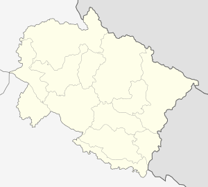
| State | Uttarakhand |
| District | Champawat |
| Elevation | 466 m (1,529 ft) |
| Population (2001) | |
| • Total | 7,138 |
| Languages | |
| • Official | Hindi |
| Time zone | IST (UTC+5:30) |
| PIN | 262310 |
| Telephone code | 91 5943 |
| Vehicle registration | UK-03 |
| Website |
uk |
| Banbasa is in the world | |
Banbasa (बनबसा) is a census town in Champawat district in the state of Uttarakhand, India.
Demographics
As of 2001 India census,[1] Banbasa had a population of almost 8,000 (including the outer villages and communities this number could easily be higher than 80,000). Males constitute 52% of the population and females 48%. Banbasa has an average literacy rate of 97%, higher than the national average of 96%.
It is located 10 km away from Tanakpur. Banbasa is known for the Banbasa Barrage and Dam across the Sharda river, its canal and what many consider the launching point for the trip up into the mountains on the Holy Purnagiri Pilgrimage. The place abounds in sugarcane, paddy, wheat, mango orchards etc. and has a hot and humid climate, typical of the Terais, during summers, with heavy rains in late summers and hard winters.
To enter into Banbassa from Delhi one must pass through a lush 6 km stretch of jungle in which elephants, leopards, tigers, monkeys, bears, snakes, deer and many other species of wild animal are regularly seen. Much of Banbasa's outer population lives in the jungles that surround the town.
The Town & Tourism
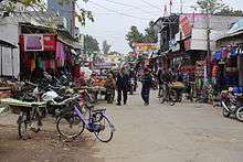
While Banbassa has several small hotels, it is not generally considered a 'tourist destination'. The majority of tourists and visitors that arrive in Banbasa are either crossing into Nepal (via Mahendranagar) or heading up in to the Himalayas and its hill stations.
A popular place to visit while staying in Banbasa is The Good Shepherd Agricultural Mission, an orphanage home for just on 100 children located just 1 km from the town -though visitors must obtain permission prior to visiting via their website. The GSAM is situated on the border of the jungle and has been registered and running since 1948.
Banbasa is a popular spot for people to cross into Nepal from India as there is an immigration office for both countries. The Nepal border is about 5 km from Banbasa and rickshaws or horse-drawn carts can be hired with ease.
Transport
Buses run direct between Banbasa and Delhi, Agra, Bareilly, Rudrapur, Nanital, Haldwani, Dehradun, Haridwar, Amritsar, Chandigarh, Shimla and many other places. Most services have several timings but some only have 1-3 buses per day. Banbasa is one of the last stops before the Himalayan mountain climb begins on the road to Almorah, Champawat and Pithoragarh.
Trains also run to Banbassa, currently the only route comes through Pilibhit though construction is underway for a direct line from Delhi.
Banbasa is near India's border with Nepal, across from the Mahendranagar municipality. Nepalese and Indian nationals may cross unrestricted, however there is a customs checkpoint for goods and third country nationals.
References
- ↑ "Census of India 2001: Data from the 2001 Census, including cities, villages and towns (Provisional)". Census Commission of India. Archived from the original on 2004-06-16. Retrieved 2008-11-01.