Ballintoy
| Ballintoy | |
| Irish: Baile an Tuaigh | |
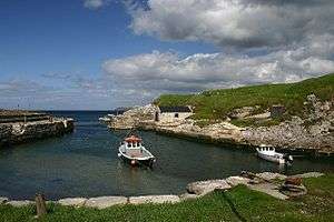 Ballintoy harbour |
|
| Population | 165 (2001 Census) |
|---|---|
| District | Moyle |
| County | County Antrim |
| Country | Northern Ireland |
| Sovereign state | United Kingdom |
| Post town | Ballintoy |
| Postcode district | BT57 |
| Dialling code | 028 |
| EU Parliament | Northern Ireland |
| UK Parliament | North Antrim |
| NI Assembly | North Antrim |
|
|
Ballintoy (from Irish Baile an Tuaigh, meaning "the northern townland") is a small village, townland (of 274 acres)[1] and civil parish in County Antrim, Northern Ireland. It is located alongside the B15 coast road, 28 km (17 mi) north-east of Coleraine, 8 km (5.0 mi) west of Ballycastle and between it and Bushmills. It is in the historic barony of Cary.[1] The village is located about one kilometre from Ballintoy Harbour, a small fishing harbour located at the end of a very small, narrow, steep road down Knocksaughey hill which passes by the entrance to Larrybane and Carrick-a-Rede Rope Bridge. The harbour is host to a dawn Service on Easter Sunday each year.
There has been no significant development within the village in the past and, as a result, Ballintoy's population has slowly declined and was only 165 people in the 2001 Census. The village has modest commercial and social facilities including tourist accommodation, restaurants, several small shops, and two churches. The best known church is the distinctive white Ballintoy Parish Church on the hill above the harbour. The village was originally built around a single street separating the inland pastures from the strip fields running towards the sea. Two of the village’s oldest hotels and pubs, the Carrick-A-Rede Hotel and the Fullerton Arms, still stand on this street. The village is in the area covered by Moyle District Council.
In 2011 residents objected to the erection of bilingual street signs in English and Irish in a petition sent to Moyle District Council after an application was requested for an English/Irish sign at Harbour Road opposite the local Church of Ireland.[2]
Game of Thrones
The village was used for the fictional town of Lordsport in the Isle of Pyke in the second season of HBO's medieval fantasy television series Game of Thrones.[3] The filming at the harbour took place on 18, 19 and 22 August 2011, and from 15 August there was a limited public access to the zone. The local shops and fishermen, who had to temporarily berth their boats in Ballycastle, were compensated by the production.[4]

Places of interest
- Bendhu House – a listed building on the road down to the harbour which was built by the artist Newton Penprase
- The remains of Dunseverick Castle are nearby and the village is only a short drive from the Giant's Causeway.
- Carrick-a-Rede Rope Bridge is just outside the village. The bridge links the mainland to the tiny Carrick Island. It is thought salmon fishermen have been erecting bridges to the island for over 300 years. The bridge spans 20 m (66 ft) and is 30 m (98 ft) above the rocks below. It is a major tourist attraction with 140,000 visitors in 2005.
- Sheep Island, County Antrim is off the north coast.
- The Parish church, built in 1813 incorporating the tower of the older church.
Civil parish of Ballintoy
Townlands
The civil parish contains the following townlands:[1][5]
A
Araboy, Artimacorkick
B
Ballinlea Lower, Ballinlea Upper, Ballintoy, Ballintoy Demesne, Ballynastraid, Broughgammon
C
Carnlelis, Carrowcroey, Clegnagh, Cloghcorr, Coolmaghra, Craig, Craigalappan, Craiganee, Croaghbeg, Croaghmore, Curramoney, Currysheskin
D
Drumnagee, Drumnagessan
G
Glenstaghey
I
Island Macallan
K
Kilmahamogue, Knocknagarvan, Knocksoghey
L
Lagavara, Lemnagh Beg, Lemnagh More, Lisbellanagroagh Beg, Lisbellanagroagh More
M
Magheraboy, Magheracashel, Maghernahar
P
Prolusk
T
Templastragh, Toberkeagh
W
See also
- List of towns and villages in Northern Ireland
- List of civil parishes in County Antrim
- List of townlands in County Antrim
| Wikimedia Commons has media related to Ballintoy. |
References
- NI Neighbourhood Information Service
- Moyle District Council
- Draft Northern Area Plan 2016
- 1 2 3 "Ballintoy". IreAtlas Townlands Database. Retrieved 14 April 2015.
- ↑ Members of church say no to Irish nameplate-Belfast Telegraph
- ↑ "Day 22: Filming at Ballintoy Harbour". WinterIsComing.net. August 15, 2011.
- ↑ "Ballintoy blockbuster! World-wide smash 'Game of Thrones' will use local harbour". Ballymoney Times. Retrieved 14 April 2015.
- ↑ "Ballintoy". Placenames Database of Ireland. Retrieved 14 April 2015.
Coordinates: 55°14′N 6°21′W / 55.233°N 6.350°W