Bagneux-la-Fosse
| Bagneux-la-Fosse | |
|---|---|
|
The Church | |
 Bagneux-la-Fosse | |
|
Location within Grand Est region  Bagneux-la-Fosse | |
| Coordinates: 47°59′36″N 4°17′55″E / 47.9933°N 4.2986°ECoordinates: 47°59′36″N 4°17′55″E / 47.9933°N 4.2986°E | |
| Country | France |
| Region | Grand Est |
| Department | Aube |
| Arrondissement | Troyes |
| Canton | Les Riceys |
| Intercommunality | Région des Riceys |
| Government | |
| • Mayor (2008–2020) | Francis Carre |
| Area1 | 22.93 km2 (8.85 sq mi) |
| Population (2010)2 | 175 |
| • Density | 7.6/km2 (20/sq mi) |
| Time zone | CET (UTC+1) |
| • Summer (DST) | CEST (UTC+2) |
| INSEE/Postal code | 10025 / 10340 |
|
1 French Land Register data, which excludes lakes, ponds, glaciers > 1 km² (0.386 sq mi or 247 acres) and river estuaries. 2 Population without double counting: residents of multiple communes (e.g., students and military personnel) only counted once. | |
Bagneux-la-Fosse is a French commune in the Aube department in the Grand Est region of north-central France.
The inhabitants of the commune are known as Bagnolais or Bagnolaises.[1]
Geography
Bagneux-la-Fosse is located some 40 km east of Saint-Florentin and 15 km south-west of Bar-sur-Seine. Access to the commune is by the D32 road from Avirey-Lingey in the north which passes through the village before continuing south to join the D452 which continues to Channes. The D17 goes west from the village the north-west to Pargues. The D26 branches off the D32 north-east of the village and goes north-east to Neuville-sur-Seine. There is a large forest in the north-west of the commune and a smaller forest in the south-east with the rest of the commune farmland.[2]
The Sarce river flows through the commune from south to north just east of the village and continues north to join the Seine at Virey-sous-Bar.[2]
Neighbouring communes and villages[3]
 |
Pargues | Avirey-Lingey | Balnot-sur-Laignes | |
| Balnot-la-Grange | |
Les Riceys | ||
| ||||
| | ||||
| Bragelogne-Beauvoir |
Administration
| From | To | Name | Party | Position |
|---|---|---|---|---|
| 1857 | Merey | |||
| 2001 | 2008 | Marie-Paule Dupin | ||
| 2008 | 2020 | Francis Carre |
(Not all data is known)
Demography
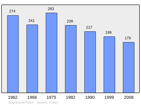
In 2010 the commune had 175 inhabitants. The evolution of the number of inhabitants is known from the population censuses conducted in the commune since 1793. From the 21st century, a census of communes with fewer than 10,000 inhabitants is held every five years, unlike larger communes that have a sample survey every year.[Note 1]
| 1793 | 1800 | 1806 | 1821 | 1831 | 1836 | 1841 | 1846 | 1851 |
|---|---|---|---|---|---|---|---|---|
| 695 | 719 | 727 | 798 | 788 | 764 | 756 | 760 | 743 |
| 1856 | 1861 | 1866 | 1872 | 1876 | 1881 | 1886 | 1891 | 1896 |
|---|---|---|---|---|---|---|---|---|
| 685 | 691 | 668 | 673 | 587 | 577 | 579 | 546 | 515 |
| 1901 | 1906 | 1911 | 1921 | 1926 | 1931 | 1936 | 1946 | 1954 |
|---|---|---|---|---|---|---|---|---|
| 507 | 476 | 470 | 380 | 361 | 325 | 351 | 343 | 313 |
| 1962 | 1968 | 1975 | 1982 | 1990 | 1999 | 2006 | 2010 | - |
|---|---|---|---|---|---|---|---|---|
| 274 | 241 | 283 | 239 | 217 | 199 | 189 | 175 | - |
Sources : Ldh/EHESS/Cassini until 1962, INSEE database from 1968 (population without double counting and municipal population from 2006)
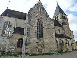
Sites and monuments
The Church (15th century)![]() is registered as an historical monument.[5] The church contains many items that are registered as historical objects:
is registered as an historical monument.[5] The church contains many items that are registered as historical objects:
- A Pulpit (18th century)
 [6]
[6] - A Tombstone (17th century)[7]
- The Tombstone of François Merey (18th century)[8]
- The Tombstone of Marie Viviane Leclerc (18th century)[9]
- The Tombstone of Nicolas Babeau (1696)[10]
- The lateral Altars (19th century)[11]
- 2 Reliquaries (19th century)[12]
- A Monstrance (19th century)[13]
- A Processional Banner: Saint Valentine (19th century)[14]
- A Chasuble (19th century)[15]
- A Painting: Way of the Cross (19th century)[16]
- A Commemorative Plaque (1533)[17]
- An Eagle Lectern (19th century)[18]
- A Statuette on a Processional Staff: Virgin and child (disappeared) (18th century)[19]
- The Furniture in the Church[20]
See also
External links
- Bagneux-la-Fosse on the old National Geographic Institute website (French)
- Bagneux-la-Fosse on Lion1906
- Bagneux-la-Fosse on Google Maps
- Bagneux-la-Fosse on Géoportail, National Geographic Institute (IGN) website (French)
- Bagneux on the 1750 Cassini Map
- Bagneux-la-Fosse on the INSEE website (French)
- INSEE (French)
Notes and references
Notes
- ↑ At the beginning of the 21st century, the methods of identification have been modified by Law No. 2002-276 of 27 February 2002, the so-called "law of local democracy" and in particular Title V "census operations" allows, after a transitional period running from 2004 to 2008, the annual publication of the legal population of the different French administrative districts. For communes with a population greater than 10,000 inhabitants, a sample survey is conducted annually, the entire territory of these communes is taken into account at the end of the period of five years. The first "legal population" after 1999 under this new law came into force on 1 January 2009 and was based on the census of 2006.
References
- ↑ Inhabitants of Aube (French)
- 1 2 Google Maps
- ↑ Géoportail, IGN (French)
- ↑ List of Mayors of France (French)
- ↑ Ministry of Culture, Mérimée PA00078025 Church (French)

- ↑ Ministry of Culture, Palissy PM10000116 Pulpit
(French)
- ↑ Ministry of Culture, Palissy IM10003728 Tombstone
(French)
- ↑ Ministry of Culture, Palissy IM10003727 Tombstone of François Merey (French)
- ↑ Ministry of Culture, Palissy IM10003726 Tombstone of Marie Viviane Leclerc
(French)
- ↑ Ministry of Culture, Palissy IM10003725 Tombstone of Nicolas Babeau
(French)
- ↑ Ministry of Culture, Palissy IM10003724 Lateral Altars
(French)
- ↑ Ministry of Culture, Palissy IM10003723 2 Reliquaries
(French)
- ↑ Ministry of Culture, Palissy IM10003722 Monstrance
(French)
- ↑ Ministry of Culture, Palissy IM10003721 Processional Banner: Saint Valentine (French)
- ↑ Ministry of Culture, Palissy IM10003720 Chasuble
(French)
- ↑ Ministry of Culture, Palissy IM10003719 Painting: Way of the Cross
(French)
- ↑ Ministry of Culture, Palissy IM10003378 Commemorative Plaque
(French)
- ↑ Ministry of Culture, Palissy IM10003377 Eagle Lectern
(French)
- ↑ Ministry of Culture, Palissy IM10003376 Statuette on a Processional Staff: Virgin and child (French)
- ↑ Ministry of Culture, Palissy IM10003773 Furniture in the Church (French)
| Wikimedia Commons has media related to Bagneux-la-Fosse. |