Bös Fulen
This article is about mountain Bös Fulen of the Schwyz Alps. For other uses, see Fulen.
| Bös Fulen | |
|---|---|
 | |
| Highest point | |
| Elevation | 2,802 m (9,193 ft) |
| Prominence | 368 m (1,207 ft) [1] |
| Isolation | 4.3 km (2.7 mi) [2] |
| Parent peak | Glärnisch |
| Listing | Canton high point |
| Coordinates | 46°58′2″N 8°56′45″E / 46.96722°N 8.94583°ECoordinates: 46°58′2″N 8°56′45″E / 46.96722°N 8.94583°E |
| Naming | |
| Translation | Bad Fulen (German) |
| Geography | |
 Bös Fulen Location in Switzerland | |
| Location | Glarus/Schwyz |
| Country | Switzerland |
| Parent range | Schwyz Alps |
| Topo map | Swiss Federal Office of Topography swisstopo |
| Geology | |
| Mountain type | Limestone |
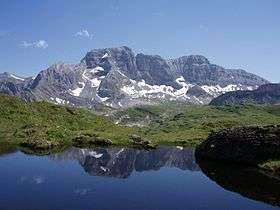
The Bös Fulen is a mountain in the Schwyz Alps, located on the border between the cantons of Schwyz and Glarus. It overlooks the valleys of Muotathal (Schwyz) and Linthal. It is the highest summit of the canton of Schwyz. Politically, it is split between the municipalities of Muotathal (Schwyz) and Glarus. Braunwald is the nearest locality.
See also
References
- ↑ Swisstopo maps
- ↑ Retrieved from Google Earth. The nearest point of higher elevation is southwest of the Bächistock.
External links
This article is issued from Wikipedia - version of the 5/8/2016. The text is available under the Creative Commons Attribution/Share Alike but additional terms may apply for the media files.