Brienzer Rothorn
| Brienzer Rothorn | |
|---|---|
|
View from the west | |
| Highest point | |
| Elevation | 2,350 m (7,710 ft) |
| Prominence | 1,342 m (4,403 ft) [1] |
| Isolation | 9.7 km (6.0 mi) [2] |
| Listing | Canton high point |
| Coordinates | 46°47′13″N 8°02′49″E / 46.78694°N 8.04694°ECoordinates: 46°47′13″N 8°02′49″E / 46.78694°N 8.04694°E |
| Naming | |
| Translation | Red Horn of Brienz (German) |
| Geography | |
 Brienzer Rothorn Location in Switzerland | |
| Country | Switzerland |
| Cantons | Lucerne, Obwalden and Bern |
| Parent range | Emmental Alps |
| Topo map | Swiss Federal Office of Topography swisstopo |
| Climbing | |
| Easiest route | mountain train from Brienz, cable car from Sörenberg |

The Brienzer Rothorn is a mountain of the Emmental Alps, in Switzerland. With an elevation of 2,350 metres above sea level, the Brienzer Rothorn is the highest summit of the range. To its west lies the Tannhorn, whilst to its east are Arnihaaggen, Höch Gumme and the Brünig Pass (1,008 m). On its south side it overlooks Lake Brienz, whilst to the north it looks out over the Waldemme valley.[3]
Administratively, the summit is shared by the municipalities of Brienz, to the south-west, Schwanden bei Brienz, to the south-east, Giswil to the north-east, and Flühli, to the north-west. Brienz and Schwanden bei Brienz are in the canton of Bern, Giswil is in the canton of Obwalden, and Flühli is in the canton of Lucerne. The Brienzer Rothorn is the highest point in the canton of Lucerne.[3]
The summit can be reached from Brienz by the Brienz Rothorn Bahn (steam train), the summit station being located at 2,244 metres on the Bernese side. It can also be reached from Sörenberg, in Flühli, by a cable car.[3]
Gallery
 Train from Brienz
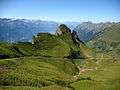 Approaching the summit
 View of Lake Brienz
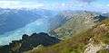 View of Lake Thun
 The summit station
See also
References
- ↑ Retrieved from the Swisstopo topographic maps. The key col is the Brünig Pass (1,008 m).
- ↑ Retrieved from Google Earth. The nearest point of higher elevation is north of the Gärstenhoren (Schwarzhorn massif).
- 1 2 3 map.geo.admin.ch (Map). Swiss Confederation. Retrieved 2014-10-21.
External links
| Wikimedia Commons has media related to Brienzer Rothorn. |