Ash-Shuyukh
| Ash-Shuyukh | |
|---|---|
| Other transcription(s) | |
| • Arabic | الشيوخ |
| • Also spelled | Al-Shuyukh (official) |
|
Ash-Shuyukh | |
 Ash-Shuyukh Location of Ash-Shuyukh within the Palestinian territories | |
| Coordinates: 31°34′41.22″N 35°08′59.73″E / 31.5781167°N 35.1499250°ECoordinates: 31°34′41.22″N 35°08′59.73″E / 31.5781167°N 35.1499250°E | |
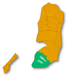
| Governorate | Hebron |
| Government | |
| • Type | Municipality |
| Area | |
| • Jurisdiction | 22,088 (Occupied 10,000) dunams (22.1 km2 or 8.5 sq mi) |
| Population (2007) | |
| • Jurisdiction | 8,811 |
| Name meaning | The Sheiks/ Shyoukhi [1] |

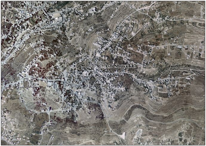
Ash-Shuyukh or al-Shuyukh (Arabic: الشيوخ) is a Palestinian town in the Hebron Governorate located 6 km northeast of the city of Hebron. According to the Palestinian Central Bureau of Statistics, Ash-Shuyukh had a population of over 8,811 in 2007.[2]
Like the rest of the Hebron area, ash-Shuyukh is an agricultural area. Primary crops include olives, figs, almonds, lentils, peaches and apricots. Olive groves cover 980 dunams while grains and pulses cover 680 dunams. There are about 2,000 sheep and goats in the town raised as livestock.[3]
History
Ottoman era
During the Ottoman era, in 1838, Edward Robinson noted esh-Shiyukh as “a well built village”.[4]
French explorer Victor Guérin visited in 1863, and noted that the village was situated on a high rocky hill. It had 200 inhabitants and a small mosque dedicated to a "Cheikh Ibrahim el-Hedmi."[5]
An Ottoman village list of about 1870 counted 33 houses and a population of 99 in Schijuch, though the population count included men only.[6]
In 1883, Palestine Exploration Fund's Survey of Western Palestine described it as a "well-built village standing high, and visible from Tekua. There are a few trees round it, and caves. The water supply is from cisterns, and there is a spring to the north."[7]
British Mandate era
In the 1922 census of Palestine conducted by the British Mandate authorities, 'Al Shiukh had a population 792 inhabitants, all Muslims.[8] This had increased at the time of the 1931 census to 925 Muslims, in 180 inhabited houses.[9]
The first school was established in 1940 by Mohammed Mahmoud Eid.[3]
In 1945 the population of Ash-Shuyukh was 1,240, all Muslims,[10] who owned 22,091 dunams of land according to an official land and population survey.[11] 1,713 dunams were plantations and irrigable land, 3,365 for cereals,[12] while 24 dunams were built-up (urban) land.[13]
1948-1967
After the 1948 Arab-Israeli War, Ash-Shuyukh was ruled by the Hashemites of Jordan.
Post 1967
Ash-Shuyukh came under Israeli occupation along with the rest of the West Bank after the 1967 Six-Day War.
Another school was built in 2002 and named in honor of a resident killed during the al-Aqsa Intifada.[3]
References
- ↑ Palmer, 1881, p. 408
- ↑ 2007 PCBS Census Palestinian Central Bureau of Statistics. p.118.
- 1 2 3 Shuyukh Agriculture, Economy and History In Arabic
- ↑ Robinson and Smith, 1841, vol 2, p. 183
- ↑ Guérin, 1869, p. 150
- ↑ Socin, 1879, p. 161
- ↑ Conder and Kitchener, 1883, SWP III, p. 309
- ↑ Barron, 1923, Table V, Sub-district of Hebron, p. 10
- ↑ Mills, 1932, p. 33
- ↑ Department of Statistics, 1945, p. 23
- ↑ Government of Palestine, Department of Statistics. Village Statistics, April, 1945. Quoted in Hadawi, 1970, p. 50 Archived 2009-07-20 at WebCite
- ↑ Government of Palestine, Department of Statistics. Village Statistics, April, 1945. Quoted in Hadawi, 1970, p. 94
- ↑ Government of Palestine, Department of Statistics. Village Statistics, April, 1945. Quoted in Hadawi, 1970, p. 144
Bibliography
- Barron, J. B., ed. (1923). Palestine: Report and General Abstracts of the Census of 1922. Government of Palestine.
- Conder, Claude Reignier; Kitchener, H. H. (1883). The Survey of Western Palestine: Memoirs of the Topography, Orography, Hydrography, and Archaeology. 3. London: Committee of the Palestine Exploration Fund.
- Department of Statistics (1945). Village Statistics, April, 1945. Government of Palestine.
- Guérin, Victor (1869). Description Géographique Historique et Archéologique de la Palestine (in French). 1: Judee, pt. 3. Paris: L'Imprimerie Nationale.
- Hadawi, Sami (1970). Village Statistics of 1945: A Classification of Land and Area ownership in Palestine. Palestine Liberation Organization Research Center.
- Mills, E., ed. (1932). Census of Palestine 1931. Population of Villages, Towns and Administrative Areas. Jerusalem: Government of Palestine.
- Palmer, E. H. (1881). The Survey of Western Palestine: Arabic and English Name Lists Collected During the Survey by Lieutenants Conder and Kitchener, R. E. Transliterated and Explained by E.H. Palmer. Committee of the Palestine Exploration Fund.
- Robinson, Edward; Smith, Eli (1841). Biblical Researches in Palestine, Mount Sinai and Arabia Petraea: A Journal of Travels in the year 1838. 2. Boston: Crocker & Brewster. (p. 185)
- Socin, A. (1879). "Alphabetisches Verzeichniss von Ortschaften des Paschalik Jerusalem". Zeitschrift des Deutschen Palästina-Vereins. 2: 135–163.
External links
- Welcome To al-Shuyukh
- Survey of Western Palestine, Map 21: IAA, Wikimedia commons
- Ash Shuyukh Town (Fact Sheet)
- Ash Shuyukh Town Profil
- Ash Shuyukh Town Areal Photol
- The priorities and needs for development in Ash Shuyukh town based on the community and local authorities’ assessment
| Cities |
|  |
|---|---|---|
| Towns |
| |
| Villages |
| |
| Refugee camps | ||