Beit Ummar
| Beit Ummar | |
|---|---|
| Other transcription(s) | |
| • Arabic | بيت اُمّر |
| • Also spelled |
Bayt Ummar (official) Beit Omar (unofficial) |
|
Beit Ummar, in 2011 | |
 Beit Ummar Location of Beit Ummar within the Palestinian territories | |
| Coordinates: 31°37′17″N 35°06′08″E / 31.62139°N 35.10222°ECoordinates: 31°37′17″N 35°06′08″E / 31.62139°N 35.10222°E | |
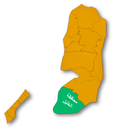
| Governorate | Hebron |
| Government | |
| • Type | Municipality (from 1997) |
| • Head of Municipality | Nasri Sabarna |
| Population (2016) | |
| • Jurisdiction | 19,892 |
| Name meaning | "House of Ummar"[1] |
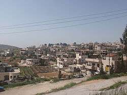
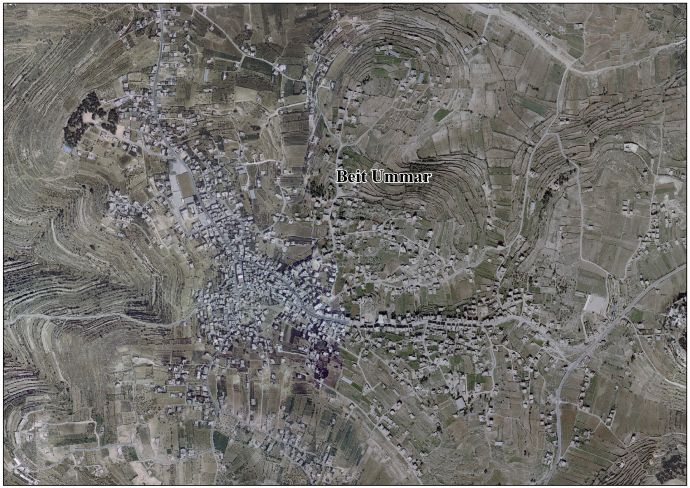
Beit Ummar (Arabic: بيت اُمّر) is a Palestinian town located eleven kilometers northwest of Hebron in the Hebron Governorate.[2] According to the Palestinian Central Bureau of Statistics, in 2016, the town had a population of 17,892 inhabitants.[3] Over 4,800 residents of the town are under the age of 18. Since the Second Intifada, unemployment ranges between 60 and 80 percent due mostly to the inability of residents to work in Israel and a depression in the Palestinian economy.[4] A part of the city straddles Road 60 and due to this, several propositions of house demolition have occurred.[5]
Beit Ummar is mostly agricultural and is noted for its many grape vines. This has a major aspect on their culinary tradition of stuffed grape leaves known as waraq al-'inib and a grape syrup called dibs.[5] Beit Ummar also has cherry, plum, apple and olive orchards.[6]
History
Beit Ummar is believed to be the site of Biblical village of Maarath.[6][7] According to some traditions, the town was named after the Islamic Caliph Umar ibn al-Khattab because he supposedly frequented the town. Many of the town's predominantly Muslim residents are descendants of Arab Christian families and the old city contains Christian ruins.[5]

The main mosque in Beit Ummar houses the tomb of Nabi Matta. Matta meaning Matthew or Amittai, father of Jonah. Mujir ad-Din writes that Matta was "a holy man from the people of the house of the prophecy." Nearby Halhul houses the tomb of Jonah with the inscription reading "Yunus ibn Matta" or "Jonah son of Amittai", confirming that Matta is indeed the Arabic name for Amittai and the Beit Ummar tomb is dedicated to Amittai.[8][9]
In 1226, the Ayyubid sultan al-Mu'azzam built a mosque with a minaret under the supervision of Jerusalem governor Rashid ad-Din al-Mu'azzami. The Mamluks constructed some additions to the mosque and engraved several inscriptions on its surface.[8]
Ottoman era
In 1838, Edward Robinson noted the village from Al-Dawayima.[10]
The French explorer Victor Guérin visited the village in 1863, and found it to have about 450 inhabitants.[11] An official Ottoman village list of about 1870 showed that Beit Ummar had a total of 44 houses and a population of 133, though the population count included men only.[12]
In 1883 the Palestine Exploration Fund's Survey of Western Palestine (SWP) described Beit Ummar as a "small but conspicuous village standing on the watershed, and visible from some distance on the north. An ancient road passes through it. Half a mile north-east is a good spring, ' Ain Kufin. The mosque has a small tower to it. The surrounding neighbourhood is covered with brushwood."[13]
British Mandate era
In the 1922 census of Palestine, conducted by the British Mandate authorities, Bait Ummar had a population of 829 inhabitants, all Muslims,[14] increasing in the 1931 census to 1,135, still entirely Muslim, in 217 inhabited houses.[15]
In 1945 the population of Beit Ummar was 80 Jews and 1,600 Muslims, and the total land area was 30,129 dunams of land according to an official land and population survey.[16][17] 2,912 dunams were plantations and irrigable land, 12,879 for cereals,[18] while 55 dunams were built-up (urban) land.[19]
1948-1967
In the wake of the 1948 Arab–Israeli War, and after the 1949 Armistice Agreements, Beit Ummar came under Jordanian rule.
Post-1967

Since the Six-Day War in 1967, Beit Ummar has been under Israeli occupation. The population in the 1967 census conducted by the Israeli authorities was 2,630.[20]
The town became a municipality on April 17, 1997 after the dismantlement of the Israeli village council and Hussein Badr was appointed by the Palestinian National Authority.[5] The current mayor is Nasri Sabarna.[21] The town is currently located in Areas B (civil affairs administered by the PNA) and C (civil and military affairs controlled by Israel).[5]
The town is governed by a municipal council consisting of thirteen members including the mayor.
Several people in the village have been shot and killed by the Israeli soldiers or settlers during Israeli occupation. In January 2011, 17-year-old Yousef Ikhlayl, was reported shot and killed by Israeli settlers. The Israeli court set released the settlers.[22][23][24]
In August 2014, Hashem Abu Maria was killed by an IDF sharpshooter. Two other Palestinians from Beit Ummar were also shot and killed.[25][26]
In April 2015, 27-year-old Ziyad Awad was shot and killed in a demonstration which started after the funeral of his cousin.[27][28][29]
Notable residents
References
- ↑ Palmer, 1881, p. 389
- ↑ Beit Ummar: Town Statistics and Facts
- ↑ 'Localities in Hebron Governorate by Type of Locality and Population Estimates, 2007-2016 ,' Palestinian Central Bureau of Statistics, 2016.
- ↑ Beit Omar Background
- 1 2 3 4 5 Sample Area Background: Beit Ummar (2000) Campaign for Secure Dwellings, Christian Peacemaker Teams
- 1 2 Beit Ummar: Where Dreams Come True Aging with Dignity in Palestinian Villages Qleibo, Ali. This Week in Palestine.
- ↑ Armstrong, 1889, p.119
- 1 2 Sharon, 1999, pp. 161-164
- ↑ Clermont-Ganneau, 1899, p. 456
- ↑ Robinson and Smith, 1841, vol2, p. 401
- ↑ Guérin, 1869, p. 298
- ↑ Socin, 1879, p. 145
- ↑ Conder and Kitchener, 1883, SWP III, p. 303
- ↑ Barron, 1923, Table V, Sub-district of Hebron, p. 10
- ↑ Mills, 1932, p. 27
- ↑ Department of Statistics, 1945, p. 23
- ↑ Government of Palestine, Department of Statistics. Village Statistics, April, 1945. Quoted in Hadawi, 1970, p. 50
- ↑ Government of Palestine, Department of Statistics. Village Statistics, April, 1945. Quoted in Hadawi, 1970, p. 93
- ↑ Government of Palestine, Department of Statistics. Village Statistics, April, 1945. Quoted in Hadawi, 1970, p. 143
- ↑ Perlmann, Joel (November 2011 – February 2012). "The 1967 Census of the West Bank and Gaza Strip: A Digitized Version" (PDF). Levy Economics Institute. Retrieved 24 June 2016.
- ↑ Municipality Guide Nablus Municipality Official Website Archived December 4, 2007, at the Wayback Machine.
- ↑ Palestinian killed in clashes with settlers near Hebron, 01/29/2011, Jerusalem Post
- ↑ Court releases hikers suspected of killing Palestinian teen 02/03/2011, Jerusalem Post
- ↑ Demanding justice for Yousef, a quiet boy killed by Israeli settlers, Bekah Wolf 27 January 2012, The Electronic Intifada
- ↑ A bullet through the heart of a Palestinian man - and an entire community By Gideon Levy and Alex Levac 15.08.14 Haaretz
- ↑ West Bank Palestinians die in fresh clashes, 25 Jul 2014, Al Jazeera
- ↑ 27-year-old Palestinian killed near Hebron after funeral of his cousin, 10 April 2015 Middleeasteye.ne
- ↑ Palestinian killed in clashes with Israeli forces, 10 April 2015, The Daily Mail
- ↑ Ha'aretz 10/4/2015
Bibliography
| Wikimedia Commons has media related to Beit Ummar. |
- Armstrong, George (1889). Names and Places in the Old and New Testament and Apocrypha. Committee of the Palestine Exploration Fund.
- Barron, J. B., ed. (1923). Palestine: Report and General Abstracts of the Census of 1922. Government of Palestine.
- Clermont-Ganneau, Charles Simon (1899). [ARP] Archaeological Researches in Palestine 1873-1874, translated from the French by J. McFarlane. 1. London: Palestine Exploration Fund.
- Conder, Claude Reignier; Kitchener, H. H. (1883). The Survey of Western Palestine: Memoirs of the Topography, Orography, Hydrography, and Archaeology. 3. London: Committee of the Palestine Exploration Fund.
- Department of Statistics (1945). Village Statistics, April, 1945. Government of Palestine.
- Guérin, Victor (1869). Description Géographique Historique et Archéologique de la Palestine. Vol 1; Judee, pt. 3.
- Hadawi, Sami (1970). Village Statistics of 1945: A Classification of Land and Area ownership in Palestine. Palestine Liberation Organization Research Center.
- Hütteroth, Wolf-Dieter; Abdulfattah, Kamal (1977). Historical Geography of Palestine, Transjordan and Southern Syria in the Late 16th Century. Erlanger Geographische Arbeiten, Sonderband 5. Erlangen, Germany: Vorstand der Fränkischen Geographischen Gesellschaft. ISBN 3-920405-41-2.
- Mills, E., ed. (1932). Census of Palestine 1931. Population of Villages, Towns and Administrative Areas. Jerusalem: Government of Palestine.
- Palmer, E. H. (1881). The Survey of Western Palestine: Arabic and English Name Lists Collected During the Survey by Lieutenants Conder and Kitchener, R. E. Transliterated and Explained by E.H. Palmer. Committee of the Palestine Exploration Fund.
- Robinson, Edward; Smith, Eli (1841). Biblical Researches in Palestine, Mount Sinai and Arabia Petraea: A Journal of Travels in the year 1838. 2. Boston: Crocker & Brewster.
- Sharon, Moshe (1999). Corpus Inscriptionum Arabicarum Palaestinae, B-C. II. BRILL. ISBN 9004110836.
- Socin, A. (1879). "Alphabetisches Verzeichniss von Ortschaften des Paschalik Jerusalem". Zeitschrift des Deutschen Palästina-Vereins. 2: 135–163.
External links
- Welcome To Bayt Ummar
- Survey of Western Palestine, Map 21: IAA, Wikimedia commons
- Beit Ummar Town (Fact Sheet)
- Beit Ummar Town Profile
- Beit Ummar aerial photo
- The priorities and needs for development in Beit Ummar town based on the community and local authorities’ assessment
| Cities |
|  |
|---|---|---|
| Towns |
| |
| Villages |
| |
| Refugee camps | ||