Arta (regional unit)
| Arta Περιφερειακή ενότητα Άρτας | |
|---|---|
| Regional unit | |
|
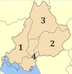
Municipalities of Arta | |
 Arta within Greece | |
| Coordinates: 39°15′N 21°15′E / 39.250°N 21.250°ECoordinates: 39°15′N 21°15′E / 39.250°N 21.250°E | |
| Country | Greece |
| Region | Epirus |
| Capital | Arta |
| Area | |
| • Total | 1,662 km2 (642 sq mi) |
| Population (2011) | |
| • Total | 67,877 |
| • Density | 41/km2 (110/sq mi) |
| Postal codes | 47x xx |
| Area codes | 268x0 |
| ISO 3166 code | GR-31 |
| Car plates | ΑΤ |
| Website |
www |
Arta (Greek: Περιφερειακή ενότητα Άρτας) is one of the regional units of Greece. It is part of the Epirus region. Its capital is the town of Arta.
Geography
The regional unit of Arta is located north of the Ambracian Gulf. The main mountain ranges are the Athamanika in the northeast, the Pindus in the east, and Valtou in the southeast. Only one mountain road links Arta with the Pineios valley and Thessaly. There are low-lying agricultural plains in the west. Arta borders on the regional units of Preveza in the west, Ioannina to the north, Trikala in the east, Karditsa to the east and Aetolia-Acarnania to the south.
The main rivers are the Acheloos in the east, the Arachthos in the centre, and the Louros in the west. Most of the population lives in the west, in the Arachthos valley, south and east of Arta. The Athamanika and Valtou mountains are the least populated.
Administration
The regional unit Arta is subdivided into 4 municipalities. These are (number as in the map in the infobox):[1]
- Arta (1)
- Central Tzoumerka (Kentrika Tzoumerka, 3)
- Georgios Karaiskakis (2)
- Nikolaos Skoufas (4)
Prefecture
Arta was established as a prefecture in 1882 (Greek: Νομός Άρτας). As a part of the 2011 Kallikratis government reform, the regional unit Arta was created out of the former prefecture Arta. The prefecture had the same territory as the present regional unit. At the same time, the municipalities were reorganised, according to the table below.[1]

| New municipality | Old municipalities | Seat |
|---|---|---|
| Arta | Arta | Arta |
| Amvrakikos | ||
| Vlacherna | ||
| Xirovouni | ||
| Filothei | ||
| Central Tzoumerka (Kentrika Tzoumerka) | Athamania | Vourgareli |
| Agnanta | ||
| Theodoriana | ||
| Melissourgoi | ||
| Georgios Karaiskakis | Georgios Karaiskakis | Ano Kalentini |
| Irakleia | ||
| Tetrafylia | ||
| Nikolaos Skoufas | Peta | Peta |
| Arachthos | ||
| Kommeno | ||
| Kompoti |
History
Arta was one of the capitals of the Despotate of Epirus in the late Middle Ages. The territory of the regional unit was ceded to Greece in 1881 by the Ottoman Empire, along with Thessaly, in accordance with the 1878 Congress of Berlin. A famous landmark of Arta is the Old Bridge over the Arachthos river.
Transport
As one of the first completed sections of the future Ionia Odos linking Ioannina with Patras and Kalamata, the motorway bypass of the GR-5 around Arta was opened in 1997. The main highways are:
- Greek National Road 5/E55, S, Cen., W
- Greek National Road 21, W
- Greek National Road 30, Cen., E
Sporting teams
People
- Pyrrhus (318 BC-272 BC) general and king of Epirus
- Epicrates of Ambracia, 4th BC comic poet
- Silanus of Ambracia
- Epigonus of Ambracia 6th-5th BC musician
- Georgios Karaiskakis Years of service 1796 - 1827 Rank - General, Battles/wars Greek War of Independence
- Maximus the Greek (c. 1475-1556) publicist, writer, scholar, humanist and translator
- Napoleon Zervas (1891–1957)
- Theodoros Tzinis
- Nikolaos Skoufas
- Yannis Makriyannis
- Kostas Kristallis poet
- Yiannis Moralis (1916) painter
- Antonios Nikopolidis (1971) footballer
- Yannis Anastasiou (1973) footballer
- Nikos Rizos (1924 - April 20, 1999), actor
See also
External links
- http://www.nomarxia-artas.gr/index_en.php
- https://web.archive.org/web/20040602225531/http://www.culture.gr:80/maps/ipiros/arta/arta.html
- http://www.bicepirus.gr/ris/prefectures/arta.html
References
- 1 2 "Kallikratis reform law text" (PDF).
| Regional unit of Arta | 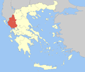 | |
|---|---|---|
| Regional unit of Ioannina | ||
| Regional unit of Preveza | ||
| Regional unit of Thesprotia | ||
| ||