Igoumenitsa
| Igoumenitsa Ηγουμενίτσα | |
|---|---|
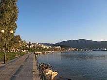
|
View of the old port | |
 Igoumenitsa | |
|
Location within the region 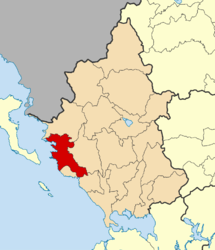 | |
| Coordinates: 39°29′N 20°16′E / 39.483°N 20.267°ECoordinates: 39°29′N 20°16′E / 39.483°N 20.267°E | |
| Country | Greece |
| Administrative region | Epirus |
| Regional unit | Thesprotia |
| Government | |
| • Mayor | Giorgos Katsinos |
| Area | |
| • Municipality | 428.4 km2 (165.4 sq mi) |
| • Municipal unit | 111.8 km2 (43.2 sq mi) |
| Highest elevation | 10 m (30 ft) |
| Lowest elevation | 0 m (0 ft) |
| Population (2011)[1] | |
| • Municipality | 25,814 |
| • Municipality density | 60/km2 (160/sq mi) |
| • Municipal unit | 17,902 |
| • Municipal unit density | 160/km2 (410/sq mi) |
| Community[1] | |
| • Population | 9,820 (2011) |
| Time zone | EET (UTC+2) |
| • Summer (DST) | EEST (UTC+3) |
| Postal code | 461 00 |
| Area code(s) | 26650 |
| Vehicle registration | ΗΝ |
| Website | www.igoumenitsa.gr |
Igoumenitsa (Greek: Ηγουμενίτσα, Greek pronunciation: [iɣumeˈnitsa]), is a coastal city in northwestern Greece. It is the capital of the regional unit of Thesprotia.
Igoumenitsa is the chief port of Thesprotia and Epirus, and one of the largest passenger ports of Greece, connecting northwestern Mainland Greece with the Ionian Islands and Italy. The city is build on easternmost end of the Gulf of Igoumenitsa in the Ionian Sea and primary aspects of the economy are maritime, transport, services, agriculture and tourism. The 670 km (420 mi) long Egnatia Highway, which serves northern Greece, terminates at Igoumenitsa, making it a popular starting point for tourists coming from Europe and ending point for trucks from Turkey.
Igoumenitsa features many shops, schools, offices and cargo storages, a Technological Educational Institute, a library, an archeological museum, several sport stadiums and tennis courses, a courthouse and a medical clinic. The Thesprotia Police Headquarters and the Municipal Sailing Club are located here. The city itself is build on the slopes of a forested mountain and expands perimetrically around the gulf.
The 2011 census recorded 25,814 inhabitants for the wider Municipality, of which 9,820 in the municipal unit of Igoumenitsa proper. Igoumenitsa is known for being surrounded by several forests and for its blue waters. The nearby Drepanos Beach is one of the longest sand beaches in the region, with a length of over 7 kilometers.
Names
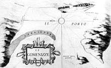
The town is located near the site of ancient Τιτάνη (Titane). In Ottoman times, a small coastal fort was built. The Venetians referred to the port as Porto delle Gomenizze, apparently the origin of the modern name. The settlement of Igoumenitsa didn't exist prior to 1913; the largest nearby village was Grava (Γράβα), with some 300 inhabitants. After 1913, a small town center began to form near the Turkish fort, with some 750 inhabitants by 1936, when it was named Igoumenitsa. The town was destroyed in 1944 and a new settlement grew up around the new ferry terminal in the 1950s and 1960s.
Municipality

The present municipality Igoumenitsa was formed at the 2011 local government reform by the merger of the following 5 former municipalities, that became municipal units (constituent communities in brackets):[2]
- Igoumenitsa (Agia Marina, Agios Vlasios, Graikochori, Igoumenitsa, Kastri, Kryovrysi, Ladochori, Mavroudi, Nea Selefkeia)
- Margariti (Eleftheri, Karteri, Katavothra, Margariti, Mazarakia, Mesovouni, Spatharaioi)
- Parapotamos (Drimitsa, Geroplatanos, Koritiani, Parapotamos)
- Perdika
- Syvota (Argyrotopos, Faskomilia, Plataria, Syvota)
The municipality has an area of 428.353 km2, the municipal unit 111.752 km2.[3]
History
In ancient times Igoumenitsa was known as Titani, and was one of the most important towns of the Kingdom of Thesprotis during the 4th century BC, covering 28 hectares. The circumference of its walls was 2,400 metres. The walls had four gates. Internal walls, in the shape of a sickle, divided the city in half. Its most noteworthy tower, located at the top of the hill, was round, and is thought to have been a religious sanctuary. Excavations have revealed a theatre which seats 2,500 and ruins of two temples.
The city was a meeting place of the Epirote League (Livy 42.38.1). A spur near Philiates between the Kalamas River, the acropolis had a fine semicircular tower. A small theater, towers, and gateways which are still visible. The Kalamas may have been navigable to this point. The city was destroyed by the Romans in 167 BC and later on it was annexed into the Roman Empire. It was ruled by Ottoman Empire and was renamed as "Reşadiye" in 1909 honour of Mehmet V, Ottoman Sultan between 1909 and 1918. During Italo-Turkish War, Hamidiye torpedo boat was sunk by an Italian destroyer on December 30, 1912[4] in here.
After the liberation of the region from Ottoman rule during the Balkan wars in 1913, the city name was Grava, a name that stayed in use until 1938, when the town became head of the prefecture of Thesprotia and was then renamed to Igoumenitsa.
Following World War II, the Muslim Cham Albanian residents of Igoumenitsa were expelled to neighbouring Albania after large parts of them collaborated with the invading German forces.[5]
Traffic

The Patras, Greece to Brindisi, Italy car–ferry ships of the Hellenic Mediterranean Lines (HML) stop at Igoumenitsa, before crossing the Adriatic Sea and vice versa, as well as the ships of Superfast Ferries, ANEK Lines and several other shipping companies, before going to Ancona, Bari or Venice in Italy, and vice versa. Frequent passenger and car ferries to and from Corfu.
The Egnatia Odos motorway, which was opened in 2009 and is part of the ![]() , has significantly enhanced the connection with Thessaloniki and Turkey and shortened the required travelling time from and to the Turkish border by several hours. Between Thessaloniki and the Turkish border, the road runs more or less parallel to the ancient Roman Via Egnatia.
, has significantly enhanced the connection with Thessaloniki and Turkey and shortened the required travelling time from and to the Turkish border by several hours. Between Thessaloniki and the Turkish border, the road runs more or less parallel to the ancient Roman Via Egnatia.
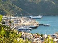
Ports


Igoumenitsa features two ports. The Old Port and the New Port, which is the second busiest passenger port of Greece, after Piraeus, even surpassing the Ports of Iraklion and Patras which are now the thirst and fourth largest in the country.
The sea-lines going to and coming from Igoumenitsa are:
|
Internal Maritime Traffic
|
External Maritime Traffic |
According to the draft strategy prepared by the relevant Ministry of Shipping (2012-2013) the port of Igoumenitsa becomes a "Connection Portal" not only of Greece with the rest of Europe, but of the whole of Europe with the Balkans, the Black Sea and the Middle East, through the development of combined transport (maritime-roads) directly and long-term (through the Egnatia railway), incorporating the railroad.
Until the beginning of the year 2012, the First Phase of the construction project of the New Port has been completed and progression to the Second Phase has begun in late 2013 and was completed by 2016, when the Third Phase of the constriction begun. With the completion of the First phase, Igoumenitsa has become a modern, large port in the Mediterranean Sea, able to serve passenger, commercial and tourist traffic. The completion of the Second Phase, enabled the port to serve large cruise ships. Also, the planned creation of a freight centre in a section within the port area, is estimated to greatly strengthen the commercial traffic and turn the city of Igoumenitsa into an international logistics centre.
Port traffic statistics as of 2012:
| Port | Passengers | Cars | Trucks |
|---|---|---|---|
| Igoumenitsa | 896.130 | 212.154 | 149.768 |
| Patras | 555.453 | 102.161 | 122.139 |
Igoumenitsa serves the 61.73% of the maritime traffic, the 67.49% of car traffic and the 55.08% of truck traffic annually.
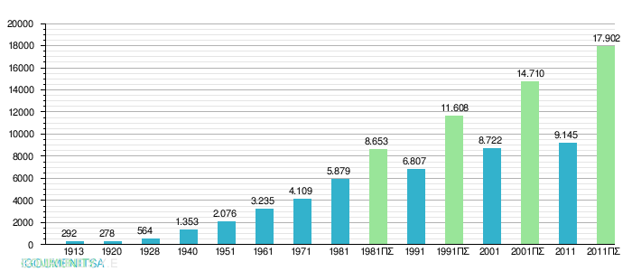
Population
The population of Igoumenitsa population is 9.145 residents and the urban area (agglomeration) is 17.902. The population of Municipality of Igoumenitsa is 25.814 permanent citizens. Igoumenitsa's population grew rapidly in recent years, as result of the increased traffic in the region because of the New Port. The chart below shows the development of the population of Igoumenitsa and the broader urban area according to the data of the Greek Statistical Agency:
 |
Climate
The average rainfall in Igoumenitsa is around 1,100 mm (43.3 in). By comparison in Athens it is only 380 mm (15.0 in); in Crete it is 640 mm (25.2 in), and in Ioannina 1,300 mm (51.2 in).
The temperature table are dated as of 2005.
| Month | Inland temperature | Sea temperature |
|---|---|---|
| January | 12 °C | 16 °C |
| February | 9 °C | 15 °C |
| March | 14 °C | 16 °C |
| April | 16 °C | 17 °C |
| May | 22 °C | 19 °C |
| June | 25 °C | 22 °C |
| July | 28 °C | 24 °C |
| August | 27 °C | 25 °C |
| September | 25 °C | 24 °C |
| October | 20 °C | 23 °C |
| November | 18 °C | 20 °C |
| December | 13 °C | 17 °C |
The water is safe for swimming between the months of May to November, that's only half a year. In 2005, the town had 65 rainy days, the summer had 4 rainy days with 10 hours of mix of sun and clouds each day. The last 25 years, the lowest temperature was −9 °C (16 °F) and the highest was 43 °C (109 °F).
Tourism
Igoumenitsa is known for its green forests and blue crystal waters, and attracts many local tourists from the nearby regions, and especially from Italy. The city provides the possibility for walks, jogging on the beach or mountain, hiking, sports, boating or contact with nature. Also provides access to the beautiful sandy beaches of Drepanos and Makrygiali with crystal clear waters with a length of 7 km, with both of them being situated on the northwestern edge of the Gulf of Igoumenitsa. The archaeological museum with exhibits from historical times until the Byzantines period. In recent years, the city has become a growing cruise destination, as cruise station for visits to archaeological sites and natural beauties of Thesprotia but also the entire Ionian coast.
Archeological Museum
The archaeological museum of Igoumenitsa was opened in 2009 and is located on the north side, next to the Fire Department of the city. Consists of five main sections that showcase the history and culture of the region of Thesprotia from ancient times to the Byzantine period: Archaeological-historical background, Settlements of historical times, Public Life, Private Life, Burial Customs.
International relations
Twin towns – sister cities
Igoumenitsa is twinned with:
Consulates and Diplomatic missions
Igoumenitsa is host to the following foreign missions:
 Germany, German Consulate
Gallery
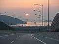 Igoumenitsa as seen from Egnatia Odos
 View of Igoumenitsa from the sea
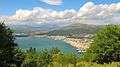 Panoramic view
 View from the New Port
 The Thesprotia's division of the Epirus Prefecture
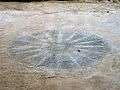 Mosaic depicting the Vergina Sun, Titani archeological site
 The Agios Dionysios island, at the Gulf of Igoumenitsa
See also
References
- 1 2 "Απογραφή Πληθυσμού - Κατοικιών 2011. ΜΟΝΙΜΟΣ Πληθυσμός" (in Greek). Hellenic Statistical Authority.
- ↑ Kallikratis law Greece Ministry of Interior (Greek)
- ↑ "Population & housing census 2001 (incl. area and average elevation)" (PDF) (in Greek). National Statistical Service of Greece.
- ↑ http://www.main-board.eu/guncel-sorunlar-ve-hayat/9383-1911-12-trablusgarp-savasinda-deniz-kuvvetleri.html
- ↑ Hermann Frank Meyer. Blutiges Edelweiß: Die 1. Gebirgs-division im zweiten Weltkrieg Bloodstained Edelweiss. The 1st Mountain-Division in WWII Ch. Links Verlag, 2008. ISBN 978-3-86153-447-1, p. 702
- ↑ Tornano a Trieste i traghetti con la Grecia
External links
- Official website (Greek)
| Regional unit of Arta | 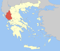 | |
|---|---|---|
| Regional unit of Ioannina | ||
| Regional unit of Preveza | ||
| Regional unit of Thesprotia | ||
| ||