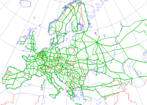
European route E55
| |
|---|---|
 | |
| Route information | |
| Length: | 3,305 km (2,054 mi) |
| Major junctions | |
| From: | Helsingborg (Sweden) |
| To: | Kalamáta (Greece) |
| Location | |
| Countries: | Sweden, Danmark, Germany, Czech Republic, Austria, Italy, Greece |
| Highway system | |
| International E-road network | |
European route E 55 is a E-route. It passes through the following cities: Helsingborg … Helsingør – Copenhagen – Køge – Vordingborg – Nykøbing Falster – Gedser … Rostock – Berlin – Lübbenau – Dresden – Teplice – Prague – Tábor – Linz – Salzburg – Villach – Tarvisio – Udine – Palmanova – Mestre – Ravenna – Cesena – Rimini – Fano – Ancona – Pescara – Canosa – Bari – Brindisi … Igoumenitsa – Preveza – Rhion – Patrai – Pyrgos – Kalamáta.[1]
From Helsingborg, the route was supposed to continue northward through Sweden and into Finland, although there, for practical reasons, it retains its former number, E 4.
- Length: 3,305 km (2,054 mi)
- First administered:
Exits and service areas in Denmark

 3 Espergærde
- 4 Kvistgård
- 5 Humlebæk
- 6 Nivå
- 7 Kokkedal
- 9 Hørsholm C
 | Isterød
- 10 Hørsholm S
- 11 Sandbjerg
- 12 Vedbæk
- 13 Gl. Holte
- 14 Nærum
- |
 Lærkereden/Storkereden
 - 15 Lundtofte
- 16 Lyngby C
 Kgs. Lyngby 19 Copenhagen
- 17 Jægersborgvej
- 18 Nyborgvej
- 19 Buddinge
- Gladsaxe 16n Hillerød 16s Copenhagen
- 20 Gladsaxe
- 21 Frederikssundvej
- 23 Jyllingevej
- Rødovre 17 Frederikssund, O4 Ballerup
- 24 Roskildevej
-
Brøndby 21v Roskilde 21ø Copenhagen
- Avedøre E20ø Malmö
- 25 Vallensbæk S
- 26 Ishøj Strand
- Ishøj O4 Ballerup, 21 Ishøj, Copenhagen V
- 27 Greve N
- 28 Greve C
- 29 Greve S
 | Karlslunde
- 30 Solrød N
- 31 Solrød S 6 Roskilde
- 32 Køge
- Køge Vest E20v Odense
- 33 Lellinge
- 34 Herfølge
- 35 Haslev
- |
 Piberhus
 - 36 Bregentved
- Rønnede 54 Næstved (2021)
- 37 Rønnede 54
- 38 Tappernøje |
- 39 Bårse
- 40 Udby
- 41 Vordingborg
- Northern Farø bridge
- 42 Farø
- Southern Farø bridge
- 43 Nørre Alslev
- 44 Eskildstrup E55s Nykøbing F, Gedser

Routes run through
After the ferry arrives in Germany, automobiles are directed over the harbor access roads in the direction of the A19. To stay on the E55, motorists enter the A19 in the direction of Berlin (southbound). Please be advised, that unlike in some other European countries, the "E" Route designation will not be clearly signed! One must be aware of the local highway number and not rely solely on the green "E" Route sign!
The A19 begins here at the Überseehafen (Oversea Harbour) just northeast of the city of Rostock. The route of the A19 travels east and south of Rostock in a mainly southerly direction for 123 km over gently rolling terrain through the state of Mecklenburg-Vorpommern and a small part of the state of Brandenburg before becoming the A24 at the Wittstock-Dosse Interchange in the direction of Berlin. Motorists wishing to drive to Hamburg on the A24 must exit.
The 63 km two-lane in each direction portion of the A24 continues through Brandenburg over mainly flat land on its way to the Havelland Interchange. There is a constant speed limit of 130 kmh (except in construction zones). This stretch of highway is notorious for numerous accidents and backups, especially in the highly travelled summer months. Just before Havelland, the highway becomes three-lanes in each direction. Here, the A24 signage ends, and the road continues as the A10 (the northerly portion of the Berliner Ring) in the direction of the Oranienburg Interchange.
The northerly portion of the Berliner Ring goes back to two-lanes after Havelland, and continues with an open speed limit until just before the Oranienburg Interchange. Here, E55 traffic will exit the A10 and follow the A111 in the direction of Berlin-Tegel.
The A111 travels due south in the direction of Berlin, and after passing the Stolpe Service Area, drops down to a 60 kmh posted speed limit. This rather slow speed limit is maintained all the way past Tegel Airport where it becomes 80 kmh, due to the residential areas and tunnels the highway passes through before getting to Tegel. After passing the airport, the A111 will join the A100 (unsigned) in a counter-clockwise direction on the west and south sides of Berlin. Northbound travellers must exit to the right at the Charlottenburg Interchange to continue on the A111.
The A100, a not yet finished inner-highway ring of Berlin, is an urban stretch of Autobahn that is built at grade, elevated, and tunnelled, as was deemed necessary during the construction of the road. It also passes along the southern perimeter of the now defunct Tempelhof Airport before splitting with the A113.
The A113 follows a route parallel to the B96a southeasterly in the direction of Schönefeld Airport. It is mostly three-lanes in each direction with posted speed limits of 80–100 kmh. The highway passes through two tunnels before approaching the airport complex. Shortly after merging with the mini-Autobahn A117, the A113 junctions with the southerly portion of the A10 - Berliner Ring and becomes the A13.
The A13 continues for 74 km south-southeast through the Spreewald Region of Bradenburg. At the Spreewald Interchange, one must exit to the right to continue on the A13. This highway will continue for another 88 km before ending at the A4, an east-west Autobahn across Central Germany, just to the north of the city of Dresden.
After joining the A4 in the direction of Dresden-Frankfurt, one will travel only 14 km of this stretch of the highway passing along the northwesterly edge of the city before exiting off onto the A17 in the direction of Prague.
The last stretch of German Autobahn on the E55 passes to the south and east of Dresden before going through the Ertzgebirge, a mountainous region along the German-Czech border. The 44 km stretch of road traverses this very hilly region offering wonderful panoramas of the surrounding countryside. Built in stages and fully opened to through traffic in 2006, the A17 consists not only of the road itself, but three tunnels and two bridges before crossing the (at the current time, unmanned) Czech border.
- Breitenau (border crossing)
- Czech Republic
- Petrovice (border crossing)
- D8 motorway, Ústí nad Labem, E 442
- Prague, E 48, E 50, E 59, E 65, E 67
- D1 motorway to Mirošovice
- Tábor
- České Budějovice E 49, E 551
- Dolní Dvořiště (border crossing)
- Austria
- Wullowitz (border crossing)
- Mühlviertler Schnellstraße
- Mühlkreis Autobahn, Linz, E 60, E 552
- Westautobahn, Salzburg, E 52, E 60, E 641
- Tauernautobahn, Villach, E 61, E 66
- Süd Autobahn
- Italy
- Greece
References
| Wikimedia Commons has media related to E55. |