Arizona State Route 90
| ||||
|---|---|---|---|---|
 | ||||
| Route information | ||||
| Maintained by ADOT | ||||
| Length: | 46.77 mi[1] (75.27 km) | |||
| Existed: | 1957 – present | |||
| Major junctions | ||||
| South end: |
| |||
| North end: |
| |||
| Highway system | ||||
| ||||

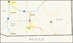
State Route 90 (SR 90) is a highway in Cochise County, Arizona that runs from the I-10 junction at Benson to a junction with State Route 80 between Bisbee and Tombstone. It is a north–south route north of Sierra Vista, and an east–west route east of the city. It passes through the San Pedro Riparian National Conservation Area at milepost 329; the riparian area makes up a large part of the southern section of the San Pedro Valley.
Route description
The northern terminus of SR 90 is located at an interchange with I-10 west in Benson. It heads south from the interchange and provides access to Kartchner Caverns State Park. It continues south from the state park to a junction with SR 82 north of Huachuca City. It continues towards the south, but curves towards the southeast before passing through Huachuca City. SR 90 continues to the southeast passing through the Fort Huachuca Military Reservation and passes near the Sierra Vista Municipal Airport. The highway turns towards the east as it enters Sierra Vista. It continues to the east along the north side of the city before curving towards the south to a junction with SR 92. As SR 92 continues south from the junction, SR 90 turns towards the east. It continues to the east until curving towards the southeast near the overpass over the San Pedro & South Western Railroad line. The highway continues to the southeast to its eastern terminus at a junction with SR 80 between Tombstone and Bisbee.[1][2]
History
The highway was constructed in the 1940s, and originally covered the route from Sierra Vista to US 80 near Bisbee. In the 1960s, the road was extended north, overtaking State Route 92's path to Whetstone and continuing north to Benson, providing easier access to Sierra Vista and Fort Huachuca from the north. This segment was widened to four lanes in the 1990s.
Junction list
The entire route is in Cochise County.
| Location | mi[1] | km | Destinations | Notes | |
|---|---|---|---|---|---|
| Benson | 0.00 | 0.00 | I-10 exit 302 | ||
| | 18.89 | 30.40 | |||
| Sierra Vista | 27.48 | 44.22 | |||
| 31.90 | 51.34 | ||||
| | 46.77 | 75.27 | |||
| 1.000 mi = 1.609 km; 1.000 km = 0.621 mi | |||||
References
- 1 2 3 Arizona Department of Transportation. "2008 ADOT Highway Log" (PDF). Retrieved 2008-04-09.
- ↑ Google (2008-04-28). "overview map of SR 90" (Map). Google Maps. Google. Retrieved 2008-04-28.