Palominas, Arizona
| Palominas, Arizona | |
|---|---|
| census-designated place | |
 Palominas Location in Arizona | |
| Coordinates: 31°22′47.36″N 110°7′6.27″W / 31.3798222°N 110.1184083°W | |
| Country | United States |
| State | Arizona |
| County | Cochise |
| Population (2010) | |
| • Total | 212 |
| Time zone | MST (no daylight saving time) (UTC-7) |
| ZIP code | 85615 |
| Area code(s) | 520 |
| Website | |
Palominas is a census-designated place located along the San Pedro River in the southern portion of Cochise County in the state of Arizona. Palominas is located very close to the community of Miracle Valley along Arizona State Highway 92. The population of Palominas as of the 2010 U.S. Census was 212.[1]
References
- ↑ "AZ - Palominas CDP". U.S. Census Bureau. Retrieved 3 April 2014.
Municipalities and communities of Cochise County, Arizona, United States | ||
|---|---|---|
| Cities | 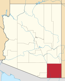 | |
| Towns | ||
| CDPs | ||
| Unincorporated communities |
| |
| Ghost towns |
| |
This article is issued from Wikipedia - version of the 6/18/2016. The text is available under the Creative Commons Attribution/Share Alike but additional terms may apply for the media files.