Bisbee, Arizona
| Bisbee, Arizona | |
|---|---|
| City | |
|
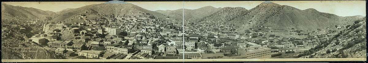
Main Street, Bisbee | |
| Motto: "An American Original" | |
 Location in Cochise County and the state of Arizona | |
 Bisbee, Arizona Location in the United States | |
| Coordinates: 31°25′6″N 109°53′52″W / 31.41833°N 109.89778°WCoordinates: 31°25′6″N 109°53′52″W / 31.41833°N 109.89778°W | |
| Country | United States |
| State | Arizona |
| County | Cochise |
| Incorporated | January 9, 1902 |
| Government | |
| • Mayor | Ron Oertle |
| Area | |
| • Total | 5.2 sq mi (13.4 km2) |
| • Land | 5.2 sq mi (13.4 km2) |
| • Water | 0.0 sq mi (0.0 km2) |
| Elevation | 5,538 ft (1,688 m) |
| Population (2010)[1] | |
| • Total | 5,575 |
| • Estimate (2014)[2] | 5,308 |
| • Density | 1,080/sq mi (417.1/km2) |
| Time zone | MST (no daylight saving time) (UTC-7) |
| ZIP code | 85603 |
| Area code | 520 |
| FIPS code | 04-06260 |
| Website | City of Bisbee |

Bisbee is a city in Cochise County, Arizona, United States, 92 miles (148 km) southeast of Tucson. According to the 2010 census, the population of the city was 5,575.[1] The city is the county seat of Cochise County.[3]
History
Bisbee was founded as a copper, gold, and silver mining town in 1880, and named in honor of Judge DeWitt Bisbee, one of the financial backers of the adjacent Copper Queen Mine.
In 1929, the county seat was moved from Tombstone to Bisbee, where it remains.
Mining industry

Mining in the Mule Mountains proved quite successful: in the early 20th century the population of Bisbee soared. Incorporated in 1902, by 1910 its population had swelled to 9,019, and it sported a constellation of suburbs, including Warren, Lowell, and San Jose, some of which had been founded on their own (ultimately less successful) mines. In 1917, open-pit mining was successfully introduced to meet the copper demand during World War I.
A high quality turquoise promoted as Bisbee Blue was a by-product of the copper mining. Many high-quality mineral specimens have come from Bisbee area mines and are to be found in museum collections worldwide. Some of these minerals include: Cuprite, aragonite, wulfenite, malachite, azurite, and galena.
Bisbee deportation
Miners attempted to organize to gain better working conditions and wages. In 1917, the Phelps Dodge Corporation, using private police, transported at gun point over 1,000 striking miners out of town to Hermanas, New Mexico, due to allegations that they were members of the Industrial Workers of the World (IWW); the company wanted to prevent unionization.[4] Earlier that year, industry police conducted the Jerome Deportation, a similar event to expel striking miners.
Mining decline and tourism
Continued underground work enabled the town to survive changes in mining. Neighboring towns had mines that closed, with a resulting dramatic loss of population. But, by 1950, the population of Bisbee had dropped to less than 6,000. In 1975 the Phelps Dodge Corporation halted its Bisbee copper-mining operations.
Bisbee Mayor Chuck Eads, with cooperation of Phelps Dodge, implemented development of a mine tour and historic interpretation of a portion of the world-famous Copper Queen Mine as part of an effort to create heritage tourism as another base for the economy. They worked to compensate for the economic loss due to the end of the mining industry in the area.
Community volunteers cleared tons of fallen rock and re-timbered the old workings. Eventually, this local effort came to the attention of the federal Economic Development Administration. It approved a large grant to the City of Bisbee to help the mine tour project and other improvements in downtown Bisbee; these were designed to meet tourist business needs. The Queen Mine Tour was officially opened to visitors on February 1, 1976. More than a million visitors, from all 50 states and more than 30 countries, have taken the underground mine tour train.
Modern Bisbee
From 1950 to 1960, the sharp population decline changed and the number of residents of Bisbee increased by nearly 160 percent when open-pit mining was undertaken and the city annexed nearby areas. The peak population was in 1960, at 9,914.
In the following decade, there was a decline in jobs and population, although not as severe as from 1930 to 1950. But, the economic volatility resulted in a crash in housing prices. Coupled with an attractive climate and picturesque scenery, Bisbee became a destination in the 1960s for artists and hippies of the counter culture.
Artist Stephen Hutchison and his wife Marcia purchased the Copper Queen Hotel, the town's anchor business and architectural gem, from the Phelps-Dodge mining company in 1970. The company had tried to find a local buyer, offering the deed to any local resident for the sum of $1, but there were no takers. The property needed renovation for continued use.

Hutchison purchased and renovated the hotel, as well as other buildings in the downtown area. One held the early 20th-century Brewery and Stock Exchange. Hutchison began to market Bisbee as a destination of the "authentic," old Southwest. His work attracted the developer Ed Smart.
Among the many guests at the hotel have been celebrities from nearby California. Actor John Wayne was a frequent visitor to Bisbee and the Copper Queen. He befriended Hutchison and eventually partnered with Smart in his real estate ventures. This period of Bisbee's history is well documented in contemporary articles in The New Yorker and in an article by Cynthia Buchanan in The Cornell Review. It was at this time that Bisbee became a haven for artists and hippies fleeing the larger cities of Arizona and California. Later it attracted people priced out by gentrification of places such as Aspen, Colorado.
In the 1990s, additional people have been attracted to Bisbee, leading it to develop such amenities as coffee shops and live theatre. Many of the old houses have been renovated, and property values in Bisbee now greatly exceed those of other southeastern Arizona cities.
Today, the historic city of Bisbee is known as "Old Bisbee" and is home to a thriving downtown cultural scene. This area is noted for its architecture, including Victorian-style houses and an elegant Art Deco county courthouse. Because its plan was laid out to a pedestrian scale before the automobile, Old Bisbee is compact and walkable. The town's hilly terrain is exemplified by the old four-story high school; each floor has a ground-level entrance.
Quirky
In the May–June 2000 issue of Modern Maturity, the AARP highlighted what they called the most "alive" places to retire in the U.S. Bisbee was a runner-up as one of the "quirkiest" towns in America.[5][6]
Suburbs

The city of Bisbee now includes the satellite communities of Warren, Lowell, and San Jose. The Lowell and Warren townsites were consolidated into Bisbee proper during the early part of the twentieth century. There are also smaller neighborhoods interspersed between these larger boroughs, including Galena, Bakerville, Tintown, South Bisbee, Briggs, and Saginaw.
Warren was Arizona's first planned community. It was designed as a bedroom community for the more affluent citizens of the mining district. Warren has a fine collection of Arts and Crafts style bungalow houses. Many have been recognized as historic places, and the city has an annual home tour during which a varying selection are offered for tours. Since the end of mining in the 1970s, Warren has seen a steady decline in its standard of living. The residential district still houses a significant portion of the population, and includes City Hall, Greenway Elementary School, Bisbee High School, and the historic Warren Ballpark.
Lowell was at one time a sizable mining town located just to the southeast of Old Bisbee. The majority of the original townsite was consumed by the excavation of the Lavender Pit mine during the 1950s. All that is left today is a small portion of Erie Street, along with Evergreen Cemetery, Saginaw subdivision and Lowell Middle School. These days Lowell is considered by most of the local residents to be more of a place name than an operating community.
San Jose, on the southern side of the Mule Mountains, is the most modern of the city's subdivisions. As it is not restricted by mountains, it has had the most new growth since the late 1990s. Named after a nearby Mexican mountain peak, it is the location of many newer county government buildings, the Huachuca Terrace Elementary School, and a large shopping center.
Resurgence of mining industry
In 2007, in what has been noted as the world's biggest-ever mining takeover, Freeport-McMoRan Copper & Gold bought Phelps Dodge Mining.[7] It began preliminary mining work in the area. Full mine operations began in 2013 with the mining of gold in addition to copper. Free-Port has invested in Bisbee by remediating soil contaminated in previous mining operations, donations to the school system,and other civic activities.
Special events
The Bisbee 1000 Stair Climb is a five-kilometer run through the city that traverses 1,034 stairs. Billed as "the most unique physical fitness challenge in the USA!" by the organizers,[8] the Climb includes runners being serenaded by musicians at various locations among the stairs. The event has grown to include the Ice Man Competition, designed to honor the history of men delivering blocks of ice by hand before the advent of refrigeration. In the Ice Man Competition, entrants race up 155 steps carrying a ten-pound block of ice with antique ice tongs.
Bisbee also hosts an annual Blues festival, occurring in 2015 during the second week of September. The festival effectively lengthens the tourist season, and provides a large amount of business to local bars and breweries.[9]
Best Historic Small Town
In 2016, Bisbee earned the title of Best Historic Small Town in both Sunset magazine and a USA Today online reader poll. Jen Luria, director of tourism in Bisbee, credited the power of social media and comedian Doug Stanhope in the USA Today win.[10] July 3, 2016 was declared "Killer Termites Day"[11] after Doug Stanhope's tenacious social media followers, The Killer Termites, persistently voted for Bisbee in the online poll.[12]
Naco and Bisbee Junction
Naco, Arizona, is a small unincorporated border community some three miles south of the San Jose district of Bisbee. It straddles the Mexico–United States border and is the site of an official port of entry. Naco features a U.S. post office, an elementary school, and several businesses, including a small store, garage, and saloon.
Bisbee Junction (formerly Osborn or Osborn Junction) is located four miles south of Warren. It was originally a railroad siding where ore trains from the Bisbee mines joined with the main Southern Pacific Railroad line. A Southern Pacific depot and U.S. Post Office building, in the style of the first half of the 20th century, were located at the railroad junction. The depot and post office were closed in the late 1950s and the building was razed soon afterward. A dance hall, an Elks club and small dry goods store were once located near the depot. The community was once the location of several cattle ranches and dairies. The Arizona Cactus Botanical Garden was located in Bisbee Junction.
Geography
Arizona State Route 80 runs through the city, leading northwest 23 miles (37 km) to Tombstone and 47 miles (76 km) to Benson, and east 26 miles (42 km) to Douglas. The Mexican border at Naco is 11 miles (18 km) south of the center of Bisbee.
According to the United States Census Bureau, the city has a total area of 5.2 square miles (13.4 km2), all of it land.[13]
Natural vegetation around Bisbee has a semi-desert appearance with shrubby acacia, oak and the like, along with cacti, grass, ocotillo and yucca. The town itself is much more luxuriant with native trees such as cypress, sycamore and cottonwood plus the introduced ailanthus and Old World cypresses, cedars and pines. Palms are capable of large size, but are not reliably hardy. A few higher-elevation trees such as blue spruce and white fir are growing fairly well in Bisbee.
Climate
Bisbee has the typical semi-arid climate (Köppen BSk) of the upland Mountain West. Summer days are warm to hot and dry before the monsoon brings the wettest season from July to September with 10.65 inches (270.5 mm) of Bisbee's total annual rainfall of 18.63 inches (473.2 mm), often with severe thunderstorms. During the winter, frontal cloudbands may bring occasional rainfall or even snowfall, though average maxima in the winter are typically very mild and sometimes even warm.
| Climate data for Bisbee, Arizona | |||||||||||||
|---|---|---|---|---|---|---|---|---|---|---|---|---|---|
| Month | Jan | Feb | Mar | Apr | May | Jun | Jul | Aug | Sep | Oct | Nov | Dec | Year |
| Record high °F (°C) | 85 (29) |
85 (29) |
88 (31) |
95 (35) |
101 (38) |
106 (41) |
104 (40) |
101 (38) |
100 (38) |
98 (37) |
90 (32) |
78 (26) |
106 (41) |
| Average high °F (°C) | 57.3 (14.1) |
60.4 (15.8) |
65.7 (18.7) |
73.6 (23.1) |
81.2 (27.3) |
89.9 (32.2) |
88.8 (31.6) |
86.0 (30) |
84.2 (29) |
76.1 (24.5) |
65.8 (18.8) |
58.1 (14.5) |
73.93 (23.3) |
| Average low °F (°C) | 34.3 (1.3) |
36.1 (2.3) |
40.3 (4.6) |
46.2 (7.9) |
53.3 (11.8) |
62.2 (16.8) |
64.3 (17.9) |
62.5 (16.9) |
59.1 (15.1) |
50.2 (10.1) |
40.8 (4.9) |
35.5 (1.9) |
48.73 (9.29) |
| Record low °F (°C) | 6 (−14) |
11 (−12) |
21 (−6) |
27 (−3) |
32 (0) |
38 (3) |
53 (12) |
47 (8) |
41 (5) |
28 (−2) |
16 (−9) |
13 (−11) |
6 (−14) |
| Average rainfall inches (mm) | 1.18 (30) |
1.20 (30.5) |
1.01 (25.7) |
0.46 (11.7) |
0.22 (5.6) |
0.70 (17.8) |
4.03 (102.4) |
4.64 (117.9) |
1.98 (50.3) |
1.05 (26.7) |
0.82 (20.8) |
1.34 (34) |
18.63 (473.4) |
| Average snowfall inches (cm) | 3.4 (8.6) |
2.2 (5.6) |
1.4 (3.6) |
0.3 (0.8) |
0.0 (0) |
0.0 (0) |
0.0 (0) |
0.0 (0) |
0.0 (0) |
0.0 (0) |
0.5 (1.3) |
2.1 (5.3) |
9.9 (25.2) |
| Average rainy days (≥ 0.01 inch) | 4 | 4 | 4 | 2 | 1 | 3 | 13 | 13 | 6 | 4 | 3 | 4 | 61 |
| Source: Western Regional Climate Center[14] | |||||||||||||
Demographics
| Historical population | |||
|---|---|---|---|
| Census | Pop. | %± | |
| 1890 | 1,535 | — | |
| 1910 | 9,019 | — | |
| 1920 | 9,205 | 2.1% | |
| 1930 | 8,023 | −12.8% | |
| 1940 | 5,853 | −27.0% | |
| 1950 | 3,801 | −35.1% | |
| 1960 | 9,914 | 160.8% | |
| 1970 | 8,328 | −16.0% | |
| 1980 | 7,154 | −14.1% | |
| 1990 | 6,288 | −12.1% | |
| 2000 | 6,090 | −3.1% | |
| 2010 | 5,575 | −8.5% | |
| Est. 2015 | 5,208 | [15] | −6.6% |
| U.S. Decennial Census[16] 2014 Estimate[2] | |||
As of the census[17] of 2000, there were 6,090 people, 2,810 households, and 1,503 families residing in the city. The population density was 1,266.3 people per square mile (488.8/km²). There were 3,316 housing units at an average density of 689.5 per square mile (266.2/km²). The racial makeup of the city was 84.12% White or European American, 0.46% Black or African American, 1.22% Native American, 0.49% Asian, 0.07% Pacific Islander, 11.07% from other races, and 2.58% from two or more races. 34.38% of the population were Hispanic or Latino of any race.
There were 2,810 households out of which 21.7% had children under the age of 18 living with them, 36.8% were married couples living together, 12.8% had a female householder with no husband present, and 46.5% were non-families. 39.1% of all households were made up of individuals and 14.6% had someone living alone who was 65 years of age or older. The average household size was 2.15 and the average family size was 2.90.
An analysis of United States Census Bureau data by researchers at The Williams Institute at the UCLA School of Law found that, on a proportional basis, Bisbee had more gay couples living together than anywhere else in the state. The ratio was 20.9 for every 1,000 households.[18]
In the city the age distribution of the population shows 21.6% under the age of 18, 6.8% from 18 to 24, 24.1% from 25 to 44, 27.8% from 45 to 64, and 19.6% who were 65 years of age or older. The median age was 43 years. For every 100 females there were 90.6 males. For every 100 females age 18 and over, there were 85.1 males.
The median income for a household in the city was $27,942, and the median income for a family was $36,685. Males had a median income of $29,573 versus $23,269 for females. The per capita income for the city was $17,129. About 12.9% of families and 17.5% of the population were below the poverty line, including 23.2% of those under age 18 and 9.0% of those age 65 or over.
Government
Bisbee is governed via the mayor-council system. The city council consists of six members who are elected from wards. Each ward elects two members, The mayor is elected in a citywide vote.
Transportation
The City of Bisbee administers the Bisbee Bus; services are operated by the City of Douglas' Douglas Rides.[19]
Sites of interest
(excluding those mentioned under History)
- Bisbee Municipal Airport
- The Central School, built in 1905, was once an elementary school and now functions as an art center.
- The Cochise County Courthouse is built in the Art Deco style.
- The Copper Queen Mine was once a major copper producer and can be toured daily.
- The Phelps Dodge General Office Building, a National Historic Landmark, is now the Bisbee Mining & Historical Museum
- The Lavender Pit is an inactive open pit mine site in the center of the city.
- Warren Ballpark, a baseball stadium built in 1909, has housed a number of professional teams and may be baseball's oldest park still in use.
- The Thomas Ranch, a family-owned and operated beef cattle ranch since 1902, the year Bisbee was incorporated
-

Cochise County Courthouse -

Copper Queen Mine Tour -
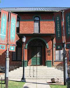
Bisbee Mining & Historical Museum -

The Lavender Pit -
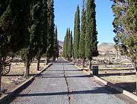
Evergreen Cemetery -

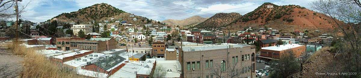
Downtown Bisbee, 1990
Sports teams
Bisbee joined with Clifton in forming a cricket team that travelled to Santa Monica, California, in 1908 to play the Santa Monica Cricket Club in two games overlooking the Pacific Ocean on the grounds of the Polo Field. The miners lost both cricket games.[20] The Copper Echo reported that Bennie, the general manager of the Shannon Company Copper Mine, was the miners' best cricketer.
- Professional: Bisbee-Douglas Copper Kings (1928–1955) (2003) Baseball
- Semi-Professional: Bisbee Kings (2006-) Baseball, Bisbee Killer Termites (2015-) Baseball, Tucson Saguaros (2016-) Baseball
Popular culture
.jpg)
Literature
- Author J. A. Jance has a series of mystery novels featuring a woman sheriff, Joanna Brady, which is set in Bisbee and the surrounding desert-mountain-border areas.
- In Clive Cussler's novel, The Chase (2007), Bisbee is one of the towns robbed by the "Butcher Bandit".
- Author Elmore Leonard's 1961 novel Hombre and its film adaptation were centered on a stagecoach bound for Bisbee.
- Author Betsy Thornton's mystery novels, including her Chloe Newcombe series, are all set in Bisbee (thinly disguised as Dudley) and the surrounding areas.[21]
Film
- Bisbee is featured in the 1957 film, 3:10 to Yuma, and its 2007 remake.
- The 1955 movie Violent Saturday, with Victor Mature and Lee Marvin, was filmed in and around Bisbee, and features many scenes of the downtown.
- In Young Guns II (1990), Pinkerton agents drag reformed outlaw Doc Scurlock (Kiefer Sutherland) from a New York City classroom; this scene was filmed in Bisbee's historic district.
- In L.A. Confidential (1997), actress Kim Basinger plays Lynn Bracken, a Veronica Lake-type beauty originally from Bisbee.
- William Shatner filmed his low-budget Groom Lake (2000) in and around Bisbee, using many local residents as extras.
- Stephen King's Desperation (2006), a TV movie based on his 1996 novel Desperation, was primarily filmed in Lowell borough, with other sequences in Old Bisbee, the city's outskirts, and Tucson, Arizona.
Music
- The song "Bisbee Blue" was included on the 2006 Calexico album, Garden Ruin.
- John Craigie has a song about Bisbee on his 2015 album Working On My Farewell.
Television
- The 1956-1958 TV series, Sheriff of Cochise, was set in and around Bisbee, legal seat of Cochise County.[22]
- A Muppet sketch from Sesame Street, featuring the Readers of the Open Range, has the members of the group helping illiterate citizens of a town. The ROTOR help them read a town sign so the residents know where they live: Bisbee, Arizona.
- In a 2005 Supernatural season 1 episode, "Skin", Dean Winchester's fake identity is as a police officer from Bisbee, Arizona.
- In a 2005 Curb Your Enthusiasm season 5 episode, "The End," Larry David is informed by a private investigator that he was, as he has suspected, adopted; he is then informed that his birth parents currently reside in "Bisby (Bisbee)", Arizona.
- In 2012, the show Ghost Adventures filmed at the Copper Queen Hotel and the Oliver House Bed & Breakfast to investigate claims of hauntings there.
Notable people
- Ben Chase, NFL player
- Gib Dawson, NFL player
- Lewis Williams Douglas, member of the U.S. House of Representatives, Director of the Bureau of the Budget under Franklin D. Roosevelt, United States Ambassador to the United Kingdom under Harry S. Truman
- M. J. Frankovich, UCLA quarterback, movie producer (The Shootist, Cactus Flower)
- Jess Hartley, author, blogger and game designer for White Wolf Games
- Earl Hindman, actor, best known for portraying Wilson W. Wilson Jr. on the sitcom Home Improvement, was born in Bisbee in 1942
- J. A. Jance, author
- Jake LaMotta ("The Raging Bull"), prizefighter, has made Bisbee one of his homes in retirement
- Clarence Maddern, professional baseball player ca. 1946 - 1951
- James F. McNulty, Jr. (1925–2009), member of the U.S. House of Representatives
- Paul Newman, Corporation Commissioner, former state representative, former Cochise County Supervisor
- Richard Shelton, author
- Doug Stanhope, comedian and writer[23]
- Betsy Thornton, writer
- Ken Westerfield, disc sports (Frisbee) pioneer, hall of fame, showman, promoter[24]
- Jack Williamson, science-fiction writer, born April 29, 1908, in Bisbee
- Peter Young, artist
See also

- Arizona Cactus Botanical Garden
- Bisbee-Douglas International Airport
- Bisbee Riot
- Lavender Pit
- List of historic properties in Bisbee, Arizona
- Mule Mountains
- Phelps Dodge
- Southeastern Arizona Bird Observatory
- USS Bisbee
- Warren–Bisbee Railway
References
- 1 2 "American FactFinder". United States Census Bureau. Retrieved 2014-08-23.
- 1 2 "Population Estimates". United States Census Bureau. Retrieved July 11, 2015.
- ↑ "Find a County". National Association of Counties. Archived from the original on 2011-05-31. Retrieved 2011-06-07.
- ↑ "Bisbee Deportation of 1917".
- ↑ International Real Estate Digest Archived June 7, 2010, at the Wayback Machine.. Retrieved 2010-03-12.
- ↑ "AARP's 50 Best Places to Live, IRED". 7 June 2010. Archived from the original on 2010-06-07.
- ↑ Bloomberg News. Retrieved 2010-03-12.
- ↑ Bisbee 1000 Stairs site Archived October 7, 2008, at the Wayback Machine.. Retrieved 2010-03-12.
- ↑ "11th Annual Bisbee Blues Festival - September 11th - 13th, 2015". 11th Annual Bisbee Blues Festival - September 11th - 13th, 2015. Retrieved 2015-12-17.
- ↑ "Bisbee named best historic small town by USA TODAY readers".
- ↑ Elle Loneprotestor (22 June 2016). "Bisbee Mayor Honors Doug Stanhope Fans, Proclaims Killer Termite Day" – via YouTube.
- ↑ "Best Historic Small Town Winners: 2016 10Best Readers' Choice Travel Awards".
- ↑ "Geographic Identifiers: 2010 Demographic Profile Data (G001): Bisbee city, Arizona". U.S. Census Bureau, American Factfinder. Retrieved June 11, 2014.
- ↑ "BISBEE, ARIZONA - Climate Summary".
- ↑ "Annual Estimates of the Resident Population for Incorporated Places: April 1, 2010 to July 1, 2015". Retrieved July 2, 2016.
- ↑ United States Census Bureau. "Census of Population and Housing". Archived from the original on May 11, 2015. Retrieved August 23, 2014.
- ↑ "American FactFinder". United States Census Bureau. Archived from the original on 2013-09-11. Retrieved 2008-01-31.
- ↑ Services, HOWARD FISCHER Capitol Media. "Census: Bisbee is most friendly to gay couples". Arizona Daily Sun. Retrieved 2016-01-30.
- ↑ "Transportation - Douglas, AZ".
- ↑ David Sentence, Cricket in America 1710-2000 (McFarland: N.Carolina, 2006) 192
- ↑ Webb, Betty. "A Song for You".
- ↑ Plot Summary for "Sheriff of Cochise" at IMDB.com. Retrieved 2010-03-12.
- ↑ Leatherman, Benjamin (May 6, 2014). "12 Celebrities Who Live in Arizona". Phoenix New Times. Archived from the original on September 25, 2014. Retrieved September 25, 2014.
- ↑ "TUC Hall of Fame Ken Westerfield". Toronto Ultimate Club. Retrieved 22 October 2014.
Further reading
- Martinelli, Phylis Cancilla. Undermining Race: Ethnic Identities in Arizona Copper Camps, 1880–1920 (Tucson: University of Arizona Press, 2009). xii, 225 pp. ISBN 978-0-8165-2745-8
External links
| Wikimedia Commons has media related to Bisbee, Arizona. |
| Wikisource has the text of the 1921 Collier's Encyclopedia article Bisbee. |
| Wikivoyage has a travel guide for Bisbee. |
- City of Bisbee official website
- Bisbee Chamber of Commerce
- Community Profile by Arizona Department of Commerce
- Sierra Vista Herald/Bisbee Daily Review (newspaper)
- The Bisbee Observer (newspaper)
- Gallery of mineral specimens, from the Bisbee exhibit at the 2008 Tucson Gem and Mineral Show
- "Treasures of the Queen" - Bisbee Mineral Exhibit at UofA, through Sept. 2012
 "Bisbee". The New Student's Reference Work. 1914.
Municipalities and communities of Cochise County, Arizona, United States | ||
|---|---|---|
| Cities | 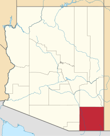 | |
| Towns | ||
| CDPs | ||
| Unincorporated communities |
| |
| Ghost towns |
| |
Rural outlaw cowboys and allies vs. business owners, townspeople, and the law | ||||||||
| Supporting rural interests |
|  | ||||||
| Supporting town interests |
| |||||||
| Conflicts and events | ||||||||
| Locations | ||||||||