Arizona State Route 82
| ||||
|---|---|---|---|---|
 | ||||
| Route information | ||||
| Maintained by ADOT | ||||
| Length: | 65.74 mi[1] (105.80 km) | |||
| Major junctions | ||||
| West end: |
| |||
| East end: |
| |||
| Highway system | ||||
| ||||

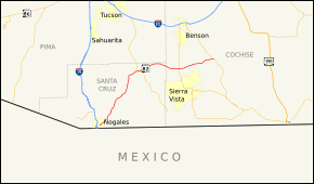
State Route 82 (SR 82) is an east–west state highway in southern Arizona. The western terminus of Route 82 is located at its junction with Business Loop 19 (Grand Avenue) in Nogales and its eastern terminus at its junction with State Route 80 just north of Tombstone. Between Nogales and Patagonia, it is also known as Patagonia Road and Patagonia Highway. Other than the aforementioned locations, Route 82 also travels through Sonoita and Whetstone, and is one of the few major east–west highways in its service area.
Route description
State Route 82 (SR 82) begins as a semicircular ramp branching from the west side of I-19 BUS (Grand Ave), crossing over the business route and turning northeast. The route runs along Patagonia Highway out of Nogales. Passing several riverbeds, the route skirts the northwest side of Nogales International Airport before turning north. The highway, which provides access to Patagonia Lake State Park, briefly enters Coronado National Forest before turning northeast again and following the Sonoita Creek. SR 82 passes through the town of Patagonia and heads through a gap between two sections of the Coronado National Forest, following an abandoned rail line. The road meets SR 83 in Sonoita, where it turns east, and intersects SR 90 in Whetstone after entering Cochise County. SR 82 then passes through the San Pedro Riparian National Conservation Area before meeting its eastern terminus at SR 80 northwest of Tombstone.[2]
History
The route was established by 1926, where it existed as an unpaved road along its current route.[3] By 1940, the route was paved northeast from Nogales to Patagonia.[4] A section from Whetstone to the eastern terminus was also paved by 1942.[5] The remaining middle portion of the route was paved by 1946.[6]
Junction list
| County | Location | mi[1] | km | Destinations | Notes |
|---|---|---|---|---|---|
| Santa Cruz | Nogales | 0.00 | 0.00 | ||
| | 30.61 | 49.26 | |||
| Cochise | | 49.84 | 80.21 | ||
| | 65.74 | 105.80 | |||
| 1.000 mi = 1.609 km; 1.000 km = 0.621 mi | |||||
References
- 1 2 Arizona Department of Transportation. "2008 ADOT Highway Log" (PDF). Retrieved April 9, 2008.
- ↑ Google (December 29, 2012). "Arizona State Route 82" (Map). Google Maps. Google. Retrieved December 29, 2012.
- ↑ Map of Arizona (Map). Arizona Highway Department. 1926. Retrieved April 7, 2012.
- ↑ Road Map of Arizona (Map). Arizona State Highway Department. 1940. Retrieved April 7, 2012.
- ↑ Road Map of Arizona (Map). Arizona State Highway Department. 1942. Retrieved April 7, 2012.
- ↑ Road Map of Arizona (Map). Arizona State Highway Department. 1946. Retrieved April 7, 2012.