Amplepuis
| Amplepuis | ||
|---|---|---|
|
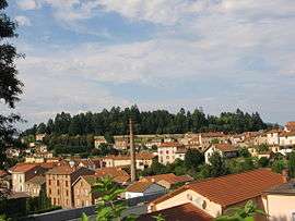
A general view of Amplepuis | ||
| ||
 Amplepuis | ||
|
Location within Auvergne-Rhône-Alpes region  Amplepuis | ||
| Coordinates: 45°58′24″N 4°19′52″E / 45.9733°N 4.3311°ECoordinates: 45°58′24″N 4°19′52″E / 45.9733°N 4.3311°E | ||
| Country | France | |
| Region | Auvergne-Rhône-Alpes | |
| Department | Rhône | |
| Arrondissement | Villefranche-sur-Saône | |
| Canton | Thizy-les-Bourgs | |
| Intercommunality | Ouest Rhodanien | |
| Government | ||
| • Mayor (2014–2020) | René Pontet | |
| Area1 | 38.44 km2 (14.84 sq mi) | |
| Population (2012)2 | 5,090 | |
| • Density | 130/km2 (340/sq mi) | |
| Time zone | CET (UTC+1) | |
| • Summer (DST) | CEST (UTC+2) | |
| INSEE/Postal code | 69006 / 69550 | |
| Elevation |
336–868 m (1,102–2,848 ft) (avg. 425 m or 1,394 ft) | |
|
1 French Land Register data, which excludes lakes, ponds, glaciers > 1 km² (0.386 sq mi or 247 acres) and river estuaries. 2 Population without double counting: residents of multiple communes (e.g., students and military personnel) only counted once. | ||
.svg.png)
Amplepuis is a commune in the Rhône department in eastern France.
Demography
| Year | 1962 | 1968 | 1975 | 1982 | 1990 | 1999 | 2006 | 2011 | 2012 |
|---|---|---|---|---|---|---|---|---|---|
| Population | 5299 | 5344 | 5340 | 5055 | 4839 | 4948 | 5184 | 5148 | 5090 |
| From the year 1962 on: No double counting—residents of multiple communes (e.g. students and military personnel) are counted only once. | |||||||||
See also
Communes of the Rhône department
References
| Wikimedia Commons has media related to Amplepuis. |
This article is issued from Wikipedia - version of the 1/8/2016. The text is available under the Creative Commons Attribution/Share Alike but additional terms may apply for the media files.