Sourcieux-les-Mines
| Sourcieux-les-Mines | ||
|---|---|---|
|
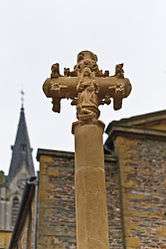
Monumental cross of the 15th century, historical monument since 1926, in front of the church | ||
| ||
 Sourcieux-les-Mines | ||
|
Location within Auvergne-Rhône-Alpes region  Sourcieux-les-Mines | ||
| Coordinates: 45°48′25″N 4°37′24″E / 45.8069°N 4.6233°ECoordinates: 45°48′25″N 4°37′24″E / 45.8069°N 4.6233°E | ||
| Country | France | |
| Region | Auvergne-Rhône-Alpes | |
| Department | Rhône | |
| Arrondissement | Villefranche-sur-Saône | |
| Canton | L'Arbresle | |
| Intercommunality | Communauté de Communes du Pays de L'Arbresle (CCPA) | |
| Government | ||
| • Mayor (2008–2014) | Robert Allognet | |
| Area1 | 9.96 km2 (3.85 sq mi) | |
| Population (1999)2 | 1,762 | |
| • Density | 180/km2 (460/sq mi) | |
| Time zone | CET (UTC+1) | |
| • Summer (DST) | CEST (UTC+2) | |
| INSEE/Postal code | 69177 / 69210 | |
| Elevation |
260–660 m (850–2,170 ft) (avg. 400 m or 1,300 ft) | |
|
1 French Land Register data, which excludes lakes, ponds, glaciers > 1 km² (0.386 sq mi or 247 acres) and river estuaries. 2 Population without double counting: residents of multiple communes (e.g., students and military personnel) only counted once. | ||
.svg.png)
Sourcieux-les-Mines is a commune in the Rhône department in eastern France.
See also
References
| Wikimedia Commons has media related to Sourcieux-les-Mines. |
This article is issued from Wikipedia - version of the 10/28/2016. The text is available under the Creative Commons Attribution/Share Alike but additional terms may apply for the media files.