Amilly, Loiret
| Amilly | ||
|---|---|---|
|
The Briare Canal at Amilly | ||
| ||
 Amilly | ||
|
Location within Centre-Val de Loire region  Amilly | ||
| Coordinates: 47°58′27″N 2°46′15″E / 47.9742°N 2.7708°ECoordinates: 47°58′27″N 2°46′15″E / 47.9742°N 2.7708°E | ||
| Country | France | |
| Region | Centre-Val de Loire | |
| Department | Loiret | |
| Arrondissement | Montargis | |
| Canton | Amilly | |
| Intercommunality | Agglomération Montargoise et Rives du Loing | |
| Government | ||
| • Mayor (2008–2014) | Gérard Dupaty | |
| Area1 | 40.26 km2 (15.54 sq mi) | |
| Population (2012)2 | 11,785 | |
| • Density | 290/km2 (760/sq mi) | |
| Time zone | CET (UTC+1) | |
| • Summer (DST) | CEST (UTC+2) | |
| INSEE/Postal code | 45004 / 45200 | |
| Elevation | 86–139 m (282–456 ft) | |
|
1 French Land Register data, which excludes lakes, ponds, glaciers > 1 km² (0.386 sq mi or 247 acres) and river estuaries. 2 Population without double counting: residents of multiple communes (e.g., students and military personnel) only counted once. | ||


Amilly is a commune and town in the Loiret department in north-central France.
Population
| Historical population | ||
|---|---|---|
| Year | Pop. | ±% |
| 1793 | 1,246 | — |
| 1800 | 1,474 | +18.3% |
| 1806 | 1,424 | −3.4% |
| 1821 | 1,441 | +1.2% |
| 1831 | 1,618 | +12.3% |
| 1836 | 1,675 | +3.5% |
| 1841 | 1,670 | −0.3% |
| 1846 | 1,824 | +9.2% |
| 1851 | 2,013 | +10.4% |
| 1856 | 2,162 | +7.4% |
| 1861 | 2,263 | +4.7% |
| 1866 | 2,093 | −7.5% |
| 1872 | 2,304 | +10.1% |
| 1876 | 2,429 | +5.4% |
| 1881 | 2,555 | +5.2% |
| 1886 | 2,594 | +1.5% |
| 1891 | 2,374 | −8.5% |
| 1896 | 2,220 | −6.5% |
| 1901 | 2,215 | −0.2% |
| 1906 | 2,235 | +0.9% |
| 1911 | 2,203 | −1.4% |
| 1921 | 2,200 | −0.1% |
| 1926 | 2,504 | +13.8% |
| 1931 | 2,934 | +17.2% |
| 1936 | 3,317 | +13.1% |
| 1946 | 3,828 | +15.4% |
| 1954 | 4,213 | +10.1% |
| 1962 | 5,468 | +29.8% |
| 1968 | 6,705 | +22.6% |
| 1975 | 8,373 | +24.9% |
| 1982 | 9,478 | +13.2% |
| 1990 | 11,029 | +16.4% |
| 1999 | 11,497 | +4.2% |
| 2006 | 11,667 | +1.5% |
| 2009 | 11,621 | −0.4% |
| 2012 | 11,785 | +1.4% |
Sights
- Church of St. Martin (16th century)
- Castles of Varenne (16th century) and of the Bourgoins (18th century)
- Bardin Watermill
- Museum of Folk Art
Twin towns
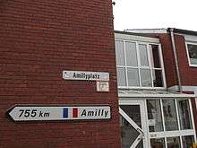
Guidepost for Amilly in twintown Nordwalde
-
 Nordwalde, Germany
 -
 Vilanova del Camí, Spain
 -
 Calcinaia, Italy
References
External links
| Wikimedia Commons has media related to Amilly (Loiret). |
This article is issued from Wikipedia - version of the 1/20/2016. The text is available under the Creative Commons Attribution/Share Alike but additional terms may apply for the media files.