Bondaroy
| Bondaroy | |
|---|---|
|
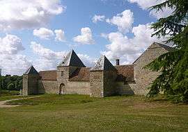
The manor in Bondaroy | |
 Bondaroy | |
|
Location within Centre-Val de Loire region  Bondaroy | |
| Coordinates: 48°10′37″N 2°16′37″E / 48.1769°N 2.2769°ECoordinates: 48°10′37″N 2°16′37″E / 48.1769°N 2.2769°E | |
| Country | France |
| Region | Centre-Val de Loire |
| Department | Loiret |
| Arrondissement | Pithiviers |
| Canton | Pithiviers |
| Intercommunality | Beauce et du Gâtinais |
| Government | |
| • Mayor (2008–2014) | Guy Grivot |
| Area1 | 6.94 km2 (2.68 sq mi) |
| Population (2009)2 | 391 |
| • Density | 56/km2 (150/sq mi) |
| Time zone | CET (UTC+1) |
| • Summer (DST) | CEST (UTC+2) |
| INSEE/Postal code | 45038 / 45300 |
| Elevation | 95–129 m (312–423 ft) |
|
1 French Land Register data, which excludes lakes, ponds, glaciers > 1 km² (0.386 sq mi or 247 acres) and river estuaries. 2 Population without double counting: residents of multiple communes (e.g., students and military personnel) only counted once. | |
Bondaroy is a commune in the Loiret department in north-central France.
Population
| Historical population | ||
|---|---|---|
| Year | Pop. | ±% |
| 1793 | 270 | — |
| 1800 | 270 | +0.0% |
| 1806 | 219 | −18.9% |
| 1821 | 241 | +10.0% |
| 1831 | 297 | +23.2% |
| 1836 | 286 | −3.7% |
| 1841 | 290 | +1.4% |
| 1846 | 301 | +3.8% |
| 1851 | 292 | −3.0% |
| 1856 | 308 | +5.5% |
| 1861 | 281 | −8.8% |
| 1866 | 278 | −1.1% |
| 1872 | 240 | −13.7% |
| 1876 | 263 | +9.6% |
| 1881 | 278 | +5.7% |
| 1886 | 261 | −6.1% |
| 1891 | 280 | +7.3% |
| 1896 | 287 | +2.5% |
| 1901 | 286 | −0.3% |
| 1906 | 268 | −6.3% |
| 1911 | 267 | −0.4% |
| 1921 | 285 | +6.7% |
| 1926 | 294 | +3.2% |
| 1931 | 261 | −11.2% |
| 1936 | 277 | +6.1% |
| 1946 | 291 | +5.1% |
| 1954 | 310 | +6.5% |
| 1962 | 290 | −6.5% |
| 1968 | 300 | +3.4% |
| 1975 | 316 | +5.3% |
| 1982 | 323 | +2.2% |
| 1990 | 347 | +7.4% |
| 1999 | 361 | +4.0% |
| 2006 | 384 | +6.4% |
| 2009 | 391 | +1.8% |
See also
References
| Wikimedia Commons has media related to Bondaroy. |
This article is issued from Wikipedia - version of the 9/17/2015. The text is available under the Creative Commons Attribution/Share Alike but additional terms may apply for the media files.